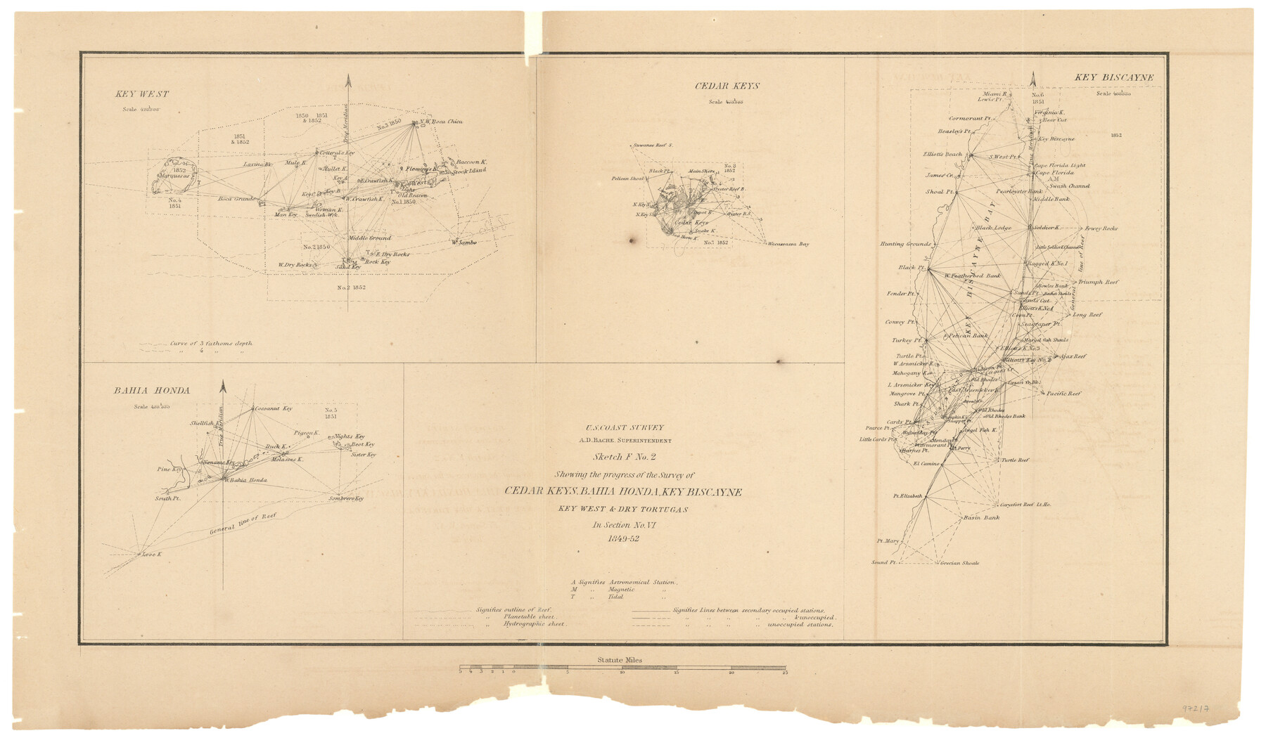
Sketch F No. 2 Showing the progress of the Survey of Cedar Keys, Bahia Honda, Key Biscayne, Key West & Dry Tortugas In Section No. VI
-
Map/Doc
97217
-
Collection
General Map Collection
-
Object Dates
1849-1852 (Creation Date)
-
People and Organizations
A.D. Bache (Superintendent)
U.S. Coast Survey (Publisher)
-
Subjects
Coastal
-
Height x Width
10.8 x 18.3 inches
27.4 x 46.5 cm
-
Comments
Sketch from the book "Report of the Superintendent of the Coast Survey Showing the Progress of the Survey in the year 1852" (81738)
Related maps
Report of the Superintendent of the Coast Survey showing the progress of the survey during the year 1852

Report of the Superintendent of the Coast Survey showing the progress of the survey during the year 1852
1853
Map/Doc 81738
Part of: General Map Collection

Hudspeth County Sketch File 28

Print $20.00
- Digital $50.00
Hudspeth County Sketch File 28
1943
Size 15.3 x 21.4 inches
Map/Doc 11803
Flight Mission No. CRE-2R, Frame 169, Jackson County

Print $20.00
- Digital $50.00
Flight Mission No. CRE-2R, Frame 169, Jackson County
1956
Size 18.6 x 22.3 inches
Map/Doc 85379
Location of the Kansas City Shreveport & Gulf Railroad, Beaumont to Mayersburg

Print $20.00
- Digital $50.00
Location of the Kansas City Shreveport & Gulf Railroad, Beaumont to Mayersburg
1896
Size 26.0 x 36.5 inches
Map/Doc 64771
McLennan County Sketch File 33

Print $4.00
- Digital $50.00
McLennan County Sketch File 33
Size 7.9 x 10.0 inches
Map/Doc 31308
Johnson County Working Sketch 27

Print $20.00
- Digital $50.00
Johnson County Working Sketch 27
2006
Size 37.3 x 44.0 inches
Map/Doc 83651
Bexar County Rolled Sketch 2

Print $20.00
- Digital $50.00
Bexar County Rolled Sketch 2
1839
Size 23.2 x 32.5 inches
Map/Doc 5135
Flight Mission No. DQN-1K, Frame 125, Calhoun County

Print $20.00
- Digital $50.00
Flight Mission No. DQN-1K, Frame 125, Calhoun County
1953
Size 18.4 x 22.1 inches
Map/Doc 84191
Stonewall County Working Sketch 22

Print $20.00
- Digital $50.00
Stonewall County Working Sketch 22
1966
Size 44.2 x 32.9 inches
Map/Doc 62329
Harris County Sketch File 92

Print $20.00
- Digital $50.00
Harris County Sketch File 92
1932
Size 37.9 x 35.0 inches
Map/Doc 10483
Starr County Sketch File 6

Print $20.00
- Digital $50.00
Starr County Sketch File 6
Size 43.4 x 36.7 inches
Map/Doc 10605
Kent County Boundary File 11

Print $4.00
- Digital $50.00
Kent County Boundary File 11
Size 13.9 x 8.8 inches
Map/Doc 55895
You may also like
Corpus Christi Pass

Print $20.00
- Digital $50.00
Corpus Christi Pass
Size 45.7 x 41.2 inches
Map/Doc 78454
Yoakum County Sketch File 21

Print $2.00
- Digital $50.00
Yoakum County Sketch File 21
2005
Size 8.5 x 14.0 inches
Map/Doc 83597
Flight Mission No. CRC-3R, Frame 51, Chambers County

Print $20.00
- Digital $50.00
Flight Mission No. CRC-3R, Frame 51, Chambers County
1956
Size 18.7 x 22.4 inches
Map/Doc 84824
Fisher County Rolled Sketch 5

Print $20.00
- Digital $50.00
Fisher County Rolled Sketch 5
1961
Size 40.3 x 32.5 inches
Map/Doc 10659
Gillespie County Working Sketch 9

Print $20.00
- Digital $50.00
Gillespie County Working Sketch 9
1994
Size 27.7 x 32.3 inches
Map/Doc 63172
Sketch of work done by Erath and Green in August 1846 on the north fork of Cow Bayou

Print $2.00
- Digital $50.00
Sketch of work done by Erath and Green in August 1846 on the north fork of Cow Bayou
1846
Size 9.8 x 7.9 inches
Map/Doc 78373
[Sketch Between Hemphill County and Oklahoma]
![89664, [Sketch Between Hemphill County and Oklahoma], Twichell Survey Records](https://historictexasmaps.com/wmedia_w700/maps/89664.tif.jpg)
Print $40.00
- Digital $50.00
[Sketch Between Hemphill County and Oklahoma]
Size 8.1 x 62.5 inches
Map/Doc 89664
Flight Mission No. DCL-5C, Frame 74, Kenedy County

Print $20.00
- Digital $50.00
Flight Mission No. DCL-5C, Frame 74, Kenedy County
1943
Size 18.6 x 22.3 inches
Map/Doc 85857
Presidio County Rolled Sketch D

Print $20.00
- Digital $50.00
Presidio County Rolled Sketch D
Size 13.7 x 22.4 inches
Map/Doc 7408
Lavaca County Working Sketch 16

Print $20.00
- Digital $50.00
Lavaca County Working Sketch 16
1977
Size 25.0 x 24.9 inches
Map/Doc 70369
Comanche County Sketch File 2

Print $40.00
- Digital $50.00
Comanche County Sketch File 2
1849
Size 16.0 x 12.9 inches
Map/Doc 19053
Liberty County Sketch File 68

Print $24.00
- Digital $50.00
Liberty County Sketch File 68
Size 11.0 x 8.5 inches
Map/Doc 94021