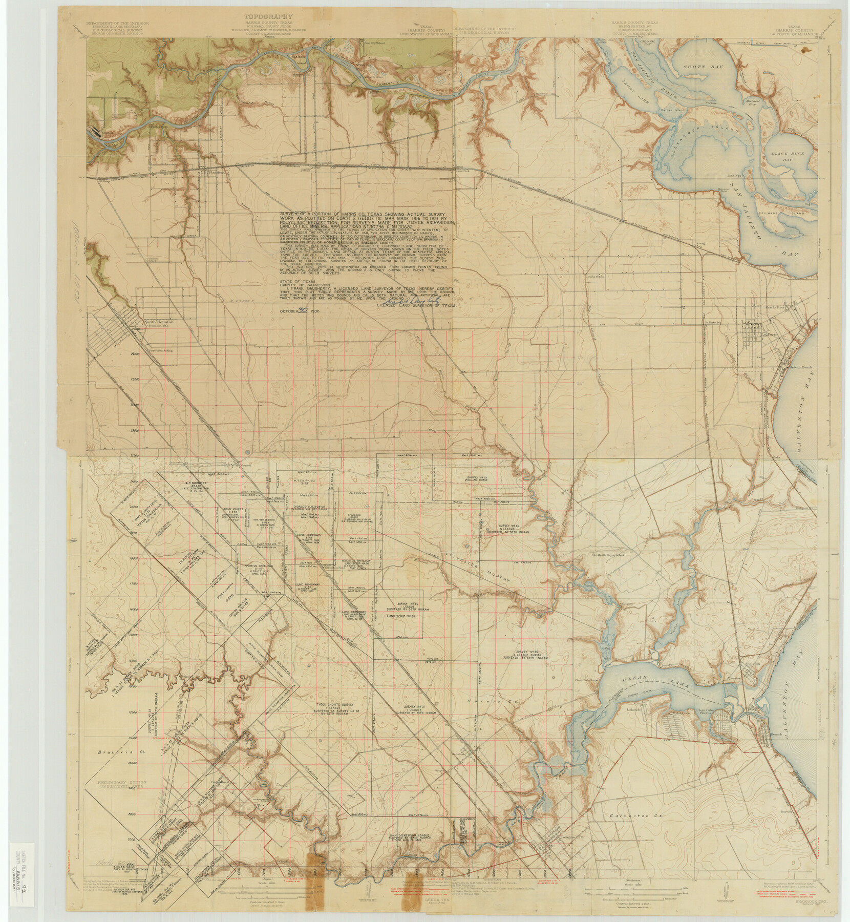
Harris County Sketch File 92
Seabrook, Tex.
-
Map/Doc
10483
-
Collection
General Map Collection
-
Object Dates
1932 (Creation Date)
1987/8/20 (File Date)
1916 (Survey Date)
1921 (Survey Date)
1824 (Survey Date)
1898 (Survey Date)
1938/10/30 (Creation Date)
1929 (Survey Date)
-
People and Organizations
Department of the Interior, U.S. Geological Survey (Publisher)
O.H. Nelson (Draftsman)
L.B. Roberts (Draftsman)
S.T. Penick (Draftsman)
Frank Daugherty (Surveyor/Engineer)
-
Counties
Harris Brazoria Chambers Galveston
-
Subjects
Surveying Sketch File
-
Height x Width
37.9 x 35.0 inches
96.3 x 88.9 cm
-
Medium
paper, print with manuscript additions
-
Scale
1:31660
-
Features
Fireworks Siding
Allen Road
Middle Bayou
Willow Springs Gully
Big Island Slough
Main Street
Little Cedar Bayou
La Porte
Sylvan Beach
Seabrook Road
Spring Gully
Red Bluff Road
Middle Bayou
GH&H
Galveston Road
GHE
Genoa Station
Genoa
Oaks
Galveston Bay
Red Bluff
Taylor Bayou
Boggy Bayou
La Porte Road
Olcott
Ellington Field
Horsepen Bayou
Old Middle Bayou School
Killkare
Pine Gully
Surf
Seabrook
Taylor Lake
Mud Lake
Wilson Avenue
Cow Bayou Gully
Clear Lake Inn
Clear Lake
Clear Lake Shores
Seabrook Bridge
Bayview
Glen Cove
Lakeside
Dredged Channel
Kemah
Jarbo Bayou
Bayview
Camp Meeting Gully
Webster
Clear Creek
Friendswood Bridge
Friendswood
Chigger Creek
U.S. Highway 75
League City
Conrad Bayou
Hunting Bayou
Houston Ship Channel
Greens Bayou
Buffalo Bayou
Penn City School
Penn City Ferry
San Jacinto Battlefield
Crystal Bay
Scott Bay
San Jacinto River
Santa Ana Bayou
Lynchburg and Cedar Bayou Road
Lyhchburg and Goose Creek Road
Peggy Lake
Barnes Island
Battle Grounds Road
Tuckers Bayou
Patrick Bayou
Boggy Bayou
Penn City Road
GH&SA
Deepwater
La Porte Road
Pooles Rest
Blakeley Road
Panner Branch of Buffalo Bayou
Clinton
Sims Bayou
Vince Bayou
El Buey
Pasadena
Colliers Corner
Red Road
Deer Park
Southern Pacific Railroad Company
Houston Road
Alexander Island
Brinson Point
Jennings Island
Spilmans Island
Hog Island
Black Duck Bay
San Jacinto Bay
Strang
East La Porte
La Porte Station
Lomax School
Berry Creek
South Houston
Part of: General Map Collection
Sketch of a reconnaissance of Aransas and Corpus Christi Bays

Print $20.00
- Digital $50.00
Sketch of a reconnaissance of Aransas and Corpus Christi Bays
1855
Size 25.7 x 18.3 inches
Map/Doc 72969
Nueces County Sketch File 46

Print $44.00
- Digital $50.00
Nueces County Sketch File 46
1907
Size 11.1 x 8.7 inches
Map/Doc 32643
Jefferson County Sketch File 21

Print $10.00
- Digital $50.00
Jefferson County Sketch File 21
Size 8.6 x 6.6 inches
Map/Doc 28171
International boundary between the United States and Mexico in the Rio Grande and Colorado River delineated in accordance with the Treaty of November 23, 1970 - Volume 1

International boundary between the United States and Mexico in the Rio Grande and Colorado River delineated in accordance with the Treaty of November 23, 1970 - Volume 1
1972
Map/Doc 1747
Connected Map of Austin's Colony

Print $20.00
- Digital $50.00
Connected Map of Austin's Colony
1892
Size 47.5 x 43.0 inches
Map/Doc 76074
[Unidentified Railroad through Denton and Dallas County]
![64775, [Unidentified Railroad through Denton and Dallas County], General Map Collection](https://historictexasmaps.com/wmedia_w700/maps/64775.tif.jpg)
Print $40.00
- Digital $50.00
[Unidentified Railroad through Denton and Dallas County]
Size 6.8 x 73.3 inches
Map/Doc 64775
Oldham County Rolled Sketch 2

Print $40.00
- Digital $50.00
Oldham County Rolled Sketch 2
1886
Size 35.7 x 55.1 inches
Map/Doc 9639
[Sketch for Mineral Application 33721 - 33725 Incl. - Padre and Mustang Island]
![2874, [Sketch for Mineral Application 33721 - 33725 Incl. - Padre and Mustang Island], General Map Collection](https://historictexasmaps.com/wmedia_w700/maps/2874.tif.jpg)
Print $20.00
- Digital $50.00
[Sketch for Mineral Application 33721 - 33725 Incl. - Padre and Mustang Island]
1941
Size 40.2 x 22.8 inches
Map/Doc 2874
Presidio County Rolled Sketch 122

Print $20.00
- Digital $50.00
Presidio County Rolled Sketch 122
1981
Size 33.9 x 28.3 inches
Map/Doc 7395
Gray County Boundary File 8

Print $4.00
- Digital $50.00
Gray County Boundary File 8
Size 14.5 x 9.1 inches
Map/Doc 53900
Aransas County Rolled Sketch 2

Print $40.00
- Digital $50.00
Aransas County Rolled Sketch 2
1950
Size 27.9 x 51.4 inches
Map/Doc 73613
Coryell County Working Sketch 26

Print $20.00
- Digital $50.00
Coryell County Working Sketch 26
1988
Size 30.7 x 30.6 inches
Map/Doc 68233
You may also like
Flight Mission No. CGI-1N, Frame 171, Cameron County

Print $20.00
- Digital $50.00
Flight Mission No. CGI-1N, Frame 171, Cameron County
1955
Size 18.5 x 22.2 inches
Map/Doc 84506
Kent County Working Sketch 22

Print $20.00
- Digital $50.00
Kent County Working Sketch 22
1987
Size 42.7 x 43.1 inches
Map/Doc 70029
Pecos County Rolled Sketch 167

Print $20.00
- Digital $50.00
Pecos County Rolled Sketch 167
1886
Size 41.1 x 27.1 inches
Map/Doc 7291
Liberty County Rolled Sketch 15

Print $20.00
- Digital $50.00
Liberty County Rolled Sketch 15
2015
Size 36.1 x 24.3 inches
Map/Doc 94022
Matagorda County Sketch File 14

Print $40.00
- Digital $50.00
Matagorda County Sketch File 14
Size 13.5 x 14.8 inches
Map/Doc 30772
Travis County Sketch File 47

Print $6.00
- Digital $50.00
Travis County Sketch File 47
1939
Size 14.3 x 8.9 inches
Map/Doc 38374
Maps of Gulf Intracoastal Waterway, Texas - Sabine River to the Rio Grande and connecting waterways including ship channels

Print $20.00
- Digital $50.00
Maps of Gulf Intracoastal Waterway, Texas - Sabine River to the Rio Grande and connecting waterways including ship channels
1966
Size 14.5 x 22.2 inches
Map/Doc 61974
Sterling County Rolled Sketch 8

Print $20.00
- Digital $50.00
Sterling County Rolled Sketch 8
1884
Size 27.9 x 31.9 inches
Map/Doc 7844

El Paso County Rolled Sketch 50

Print $40.00
- Digital $50.00
El Paso County Rolled Sketch 50
Size 19.7 x 76.0 inches
Map/Doc 76430
Gulf of Mexico

Print $20.00
- Digital $50.00
Gulf of Mexico
1905
Size 18.3 x 26.8 inches
Map/Doc 72654
Brewster County Rolled Sketch 148B

Print $20.00
- Digital $50.00
Brewster County Rolled Sketch 148B
1994
Size 28.0 x 36.3 inches
Map/Doc 5315