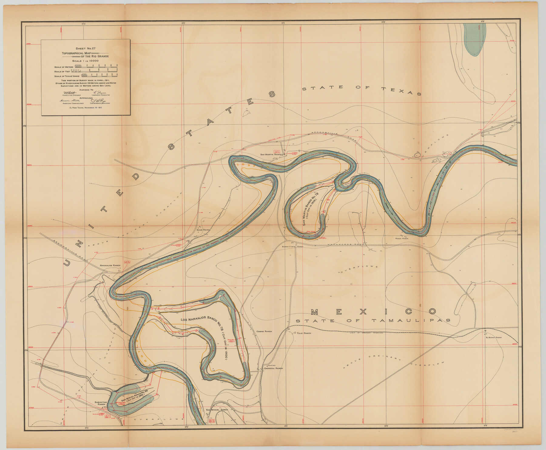
Topographical Map of the Rio Grande, Sheet No. 27
[from book: "Survey of the Rio Grande, Roma to the Gulf of Mexico, Reports and Maps"]
-
Map/Doc
89551
-
Collection
General Map Collection
-
Object Dates
1912/11/16 (Creation Date)
-
People and Organizations
International Boundary Commission (Publisher)
Anson Mills (Author)
E. Zayas (Surveyor/Engineer)
F.B. Puga (Author)
W.W. Follett (Surveyor/Engineer)
-
Subjects
River Surveys Texas Boundaries Topographic
-
Medium
paper
-
Scale
1:10000
-
Comments
This portion of the survey made in April, 1911. State of river during survey 0.8 meters above low water. Elevations are in meters above sea level. This map and 31 others were originally folded and bound into a book titled "Survey of the Rio Grande, R
Part of: General Map Collection
Hoffman & Walker's Pictorial, Historical Map of Texas

Hoffman & Walker's Pictorial, Historical Map of Texas
1960
Size 43.4 x 45.3 inches
Map/Doc 93275
Vicinity of San Luis Pass, Galveston Island, Texas

Print $40.00
- Digital $50.00
Vicinity of San Luis Pass, Galveston Island, Texas
1933
Size 36.9 x 57.2 inches
Map/Doc 69942
Maps of Gulf Intracoastal Waterway, Texas - Sabine River to the Rio Grande and connecting waterways including ship channels

Print $20.00
- Digital $50.00
Maps of Gulf Intracoastal Waterway, Texas - Sabine River to the Rio Grande and connecting waterways including ship channels
1966
Size 14.5 x 22.3 inches
Map/Doc 61944
Young County Working Sketch Graphic Index

Print $20.00
- Digital $50.00
Young County Working Sketch Graphic Index
1941
Size 44.1 x 38.4 inches
Map/Doc 76748
Coryell County Working Sketch Graphic Index

Print $20.00
- Digital $50.00
Coryell County Working Sketch Graphic Index
1936
Size 44.8 x 40.5 inches
Map/Doc 76505
Robertson County Working Sketch 12

Print $20.00
- Digital $50.00
Robertson County Working Sketch 12
1984
Size 20.6 x 22.4 inches
Map/Doc 63585
Lamb County Working Sketch 2

Print $20.00
- Digital $50.00
Lamb County Working Sketch 2
1919
Size 13.6 x 15.3 inches
Map/Doc 70275
Kendall County Rolled Sketch 6

Print $20.00
- Digital $50.00
Kendall County Rolled Sketch 6
Size 29.6 x 39.4 inches
Map/Doc 6459
El Paso County Rolled Sketch RJ

Print $40.00
- Digital $50.00
El Paso County Rolled Sketch RJ
1919
Size 56.7 x 27.2 inches
Map/Doc 8865
Carte du Canada et de la Louisiane qui forment la Nouvelle France et des colonies angloises ou sont representez les pays contestez

Print $20.00
- Digital $50.00
Carte du Canada et de la Louisiane qui forment la Nouvelle France et des colonies angloises ou sont representez les pays contestez
1756
Size 21.5 x 29.6 inches
Map/Doc 97415
Atascosa County Working Sketch 19

Print $20.00
- Digital $50.00
Atascosa County Working Sketch 19
1952
Size 24.4 x 27.3 inches
Map/Doc 67215
La Salle County Working Sketch 49

Print $20.00
- Digital $50.00
La Salle County Working Sketch 49
1984
Size 31.7 x 29.0 inches
Map/Doc 70350
You may also like
Flight Mission No. DIX-7P, Frame 14, Aransas County

Print $20.00
- Digital $50.00
Flight Mission No. DIX-7P, Frame 14, Aransas County
1956
Size 18.8 x 22.6 inches
Map/Doc 83866
Brewster County Rolled Sketch 143

Print $20.00
- Digital $50.00
Brewster County Rolled Sketch 143
1985
Size 18.3 x 28.0 inches
Map/Doc 5311
Map of the City of Galveston Situated on the East end of Galveston Island

Print $20.00
- Digital $50.00
Map of the City of Galveston Situated on the East end of Galveston Island
1838
Size 22.0 x 38.1 inches
Map/Doc 2170
Franklin County Working Sketch 1

Print $20.00
- Digital $50.00
Franklin County Working Sketch 1
1915
Size 20.4 x 11.8 inches
Map/Doc 69239
Flight Mission No. BRE-1P, Frame 66, Nueces County

Print $20.00
- Digital $50.00
Flight Mission No. BRE-1P, Frame 66, Nueces County
1956
Size 18.5 x 22.4 inches
Map/Doc 86648
Zapata County Working Sketch 22

Print $20.00
- Digital $50.00
Zapata County Working Sketch 22
1984
Size 31.8 x 40.1 inches
Map/Doc 62073
Taylor County Working Sketch 5

Print $20.00
- Digital $50.00
Taylor County Working Sketch 5
1950
Size 31.1 x 24.7 inches
Map/Doc 69615
Parker County

Print $20.00
- Digital $50.00
Parker County
1942
Size 45.7 x 37.8 inches
Map/Doc 66972
Edwards County Sketch File 7

Print $26.00
- Digital $50.00
Edwards County Sketch File 7
1880
Size 8.0 x 7.9 inches
Map/Doc 21684
Dimmit County Working Sketch 19

Print $20.00
- Digital $50.00
Dimmit County Working Sketch 19
1948
Size 27.4 x 23.3 inches
Map/Doc 68680
Lamar County Sketch File 16

Print $166.00
- Digital $50.00
Lamar County Sketch File 16
2013
Size 11.0 x 8.5 inches
Map/Doc 93654
Andrews County Rolled Sketch 14A

Print $20.00
- Digital $50.00
Andrews County Rolled Sketch 14A
1934
Size 31.2 x 23.6 inches
Map/Doc 77165