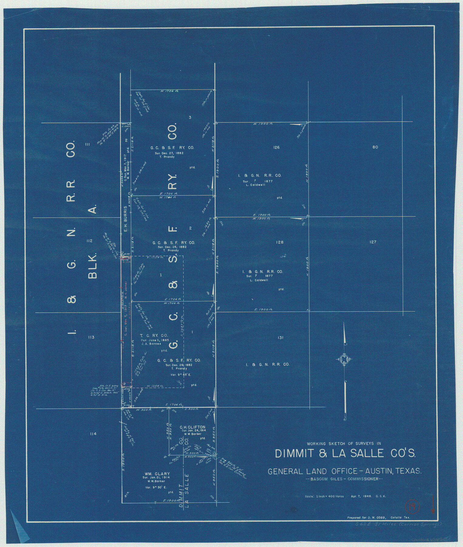
Dimmit County Working Sketch 19
-
Map/Doc
68680
-
Collection
General Map Collection
-
Object Dates
4/7/1948 (Creation Date)
-
People and Organizations
Otto G. Kurio (Draftsman)
-
Counties
Dimmit La Salle
-
Subjects
Surveying Working Sketch
-
Height x Width
27.4 x 23.3 inches
69.6 x 59.2 cm
-
Scale
1" = 400 varas
Part of: General Map Collection
Cass County Rolled Sketch BRR

Print $40.00
- Digital $50.00
Cass County Rolled Sketch BRR
1936
Size 67.3 x 28.0 inches
Map/Doc 8581
Henderson County Working Sketch 36

Print $20.00
- Digital $50.00
Henderson County Working Sketch 36
1973
Size 27.5 x 19.0 inches
Map/Doc 66169
Southern Part of Laguna Madre

Print $20.00
- Digital $50.00
Southern Part of Laguna Madre
1992
Size 44.9 x 35.0 inches
Map/Doc 73549
[Red River & Southwestern Ry. Co. from Henrietta to Archer City]
![64147, [Red River & Southwestern Ry. Co. from Henrietta to Archer City], General Map Collection](https://historictexasmaps.com/wmedia_w700/maps/64147.tif.jpg)
Print $20.00
- Digital $50.00
[Red River & Southwestern Ry. Co. from Henrietta to Archer City]
Size 14.3 x 21.1 inches
Map/Doc 64147
Starr County Working Sketch 10

Print $20.00
- Digital $50.00
Starr County Working Sketch 10
1940
Size 38.1 x 32.4 inches
Map/Doc 63926
Flight Mission No. DQO-6K, Frame 31, Galveston County

Print $20.00
- Digital $50.00
Flight Mission No. DQO-6K, Frame 31, Galveston County
1952
Size 18.5 x 22.4 inches
Map/Doc 85097
Location of the Southern Kansas Railway of Texas through Hemphill County, Texas

Print $40.00
- Digital $50.00
Location of the Southern Kansas Railway of Texas through Hemphill County, Texas
1887
Size 20.2 x 91.8 inches
Map/Doc 64000
Glasscock County

Print $20.00
- Digital $50.00
Glasscock County
1933
Size 46.4 x 38.8 inches
Map/Doc 66838
[Map of Zapata County]
![4178, [Map of Zapata County], General Map Collection](https://historictexasmaps.com/wmedia_w700/maps/4178.tif.jpg)
Print $20.00
- Digital $50.00
[Map of Zapata County]
1883
Size 20.5 x 20.9 inches
Map/Doc 4178
Dallas County Working Sketch 1

Print $20.00
- Digital $50.00
Dallas County Working Sketch 1
Size 41.4 x 28.3 inches
Map/Doc 68567
[St. Louis & Southwestern]
![64280, [St. Louis & Southwestern], General Map Collection](https://historictexasmaps.com/wmedia_w700/maps/64280.tif.jpg)
Print $20.00
- Digital $50.00
[St. Louis & Southwestern]
Size 20.3 x 27.9 inches
Map/Doc 64280
Hardin County Sketch File 52

Print $6.00
- Digital $50.00
Hardin County Sketch File 52
Size 11.5 x 8.9 inches
Map/Doc 25210
You may also like
Travis County Appraisal District Plat Map 2_1709

Print $20.00
- Digital $50.00
Travis County Appraisal District Plat Map 2_1709
Size 21.6 x 26.5 inches
Map/Doc 94210
Sherman County Sketch File B

Print $6.00
- Digital $50.00
Sherman County Sketch File B
1919
Size 14.4 x 8.8 inches
Map/Doc 36691
Navarro County Working Sketch Graphic Index

Print $40.00
- Digital $50.00
Navarro County Working Sketch Graphic Index
1924
Size 42.7 x 48.7 inches
Map/Doc 76652
Falls County Sketch File 10

Print $14.00
- Digital $50.00
Falls County Sketch File 10
Size 12.9 x 8.4 inches
Map/Doc 22345

Baylor County Working Sketch 14

Print $40.00
- Digital $50.00
Baylor County Working Sketch 14
1982
Size 33.5 x 55.1 inches
Map/Doc 67299
Working Sketch in Eastland County

Print $20.00
- Digital $50.00
Working Sketch in Eastland County
1919
Size 20.1 x 14.6 inches
Map/Doc 90931
Kimble County Working Sketch 42

Print $20.00
- Digital $50.00
Kimble County Working Sketch 42
1949
Size 40.5 x 40.0 inches
Map/Doc 70110
[Nathaniel H. Cochran Survey and Vicinity]
![91498, [Nathaniel H. Cochran Survey and Vicinity], Twichell Survey Records](https://historictexasmaps.com/wmedia_w700/maps/91498-1.tif.jpg)
Print $20.00
- Digital $50.00
[Nathaniel H. Cochran Survey and Vicinity]
Size 25.4 x 18.7 inches
Map/Doc 91498
Donley County Sketch File 10

Print $8.00
- Digital $50.00
Donley County Sketch File 10
1889
Size 9.6 x 6.1 inches
Map/Doc 21240
Terrell County Working Sketch 38

Print $40.00
- Digital $50.00
Terrell County Working Sketch 38
1950
Size 89.1 x 24.9 inches
Map/Doc 62131
General Highway Map, Kent County, Texas

Print $20.00
General Highway Map, Kent County, Texas
1940
Size 18.4 x 24.9 inches
Map/Doc 79156