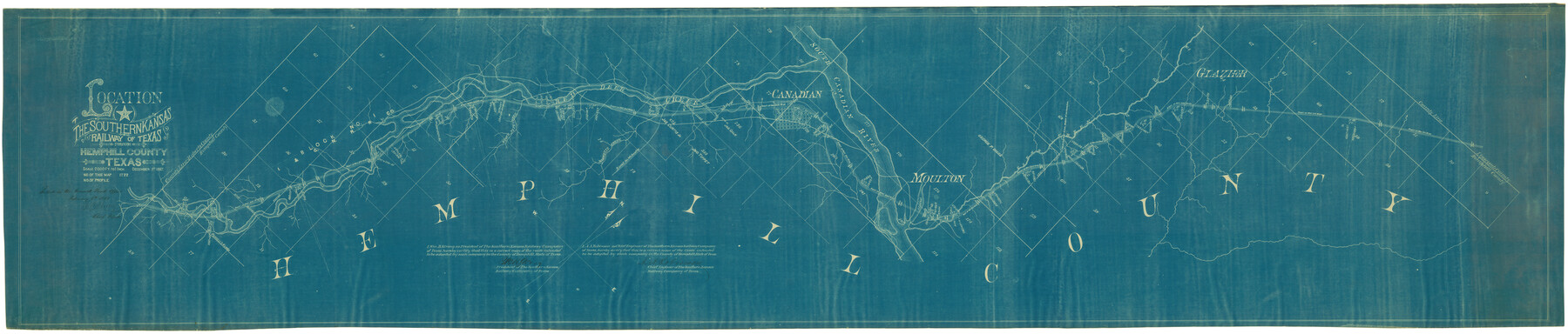
Location of the Southern Kansas Railway of Texas through Hemphill County, Texas
Southern Kansas
Z-2-1
-
Map/Doc
64000
-
Collection
General Map Collection
-
Object Dates
12/1/1887 (Creation Date)
2/8/1888 (File Date)
-
People and Organizations
A.A. Robinson (Surveyor/Engineer)
R. C. Shelley (GLO Clerk)
-
Counties
Hemphill
-
Subjects
Railroads
-
Height x Width
20.2 x 91.8 inches
51.3 x 233.2 cm
-
Medium
blueprint/diazo
-
Scale
1" = 2000 feet
-
Features
SKR
Stove Pipe Creek
Mobeetie Creek
Red Deer Creek
Road to Mobeetie
Canadian
South Canadian River
Moulton
Glazier
Part of: General Map Collection
Orange County Sketch File 35

Print $22.00
- Digital $50.00
Orange County Sketch File 35
1929
Size 11.2 x 8.5 inches
Map/Doc 33363
Ward County Working Sketch 22

Print $20.00
- Digital $50.00
Ward County Working Sketch 22
1953
Size 19.5 x 20.7 inches
Map/Doc 72328
Flight Mission No. DQO-7K, Frame 98, Galveston County

Print $20.00
- Digital $50.00
Flight Mission No. DQO-7K, Frame 98, Galveston County
1952
Size 18.8 x 22.4 inches
Map/Doc 85113
Anderson County Working Sketch 29

Print $20.00
- Digital $50.00
Anderson County Working Sketch 29
1962
Size 24.6 x 27.2 inches
Map/Doc 67029
Motley County Boundary File 2b

Print $60.00
- Digital $50.00
Motley County Boundary File 2b
Size 14.3 x 8.8 inches
Map/Doc 57521

Blanco River, Austin Girl Scouts Council

Print $6.00
- Digital $50.00
Blanco River, Austin Girl Scouts Council
1938
Size 18.5 x 31.6 inches
Map/Doc 65058
Newton County Sketch File 27

Print $4.00
- Digital $50.00
Newton County Sketch File 27
Size 13.0 x 8.6 inches
Map/Doc 32411
Jim Wells County Boundary File 2

Print $4.00
- Digital $50.00
Jim Wells County Boundary File 2
Size 8.7 x 11.3 inches
Map/Doc 55544
Oldham County Sketch File 12

Print $20.00
- Digital $50.00
Oldham County Sketch File 12
Size 20.0 x 20.1 inches
Map/Doc 12113
Polk County Sketch File 25

Print $46.00
- Digital $50.00
Polk County Sketch File 25
Size 5.7 x 28.2 inches
Map/Doc 34176
Rockwall County Boundary File 75

Print $18.00
- Digital $50.00
Rockwall County Boundary File 75
Size 9.0 x 11.7 inches
Map/Doc 58472
You may also like
Reagan County Rolled Sketch R

Print $20.00
- Digital $50.00
Reagan County Rolled Sketch R
Size 33.0 x 31.0 inches
Map/Doc 10734
Orange County Sketch File 17a

Print $4.00
- Digital $50.00
Orange County Sketch File 17a
Size 9.9 x 8.3 inches
Map/Doc 33342
Montague County Working Sketch 35

Print $20.00
- Digital $50.00
Montague County Working Sketch 35
1980
Size 24.8 x 31.9 inches
Map/Doc 71101

La Salle County Working Sketch 53

Print $20.00
- Digital $50.00
La Salle County Working Sketch 53
Size 14.3 x 15.9 inches
Map/Doc 67362
Hardin County Rolled Sketch 11

Print $20.00
- Digital $50.00
Hardin County Rolled Sketch 11
1948
Size 20.8 x 38.6 inches
Map/Doc 6083
[Block C39, Sections 22, 23 Millican Estate, 24]
![92345, [Block C39, Sections 22, 23 Millican Estate, 24], Twichell Survey Records](https://historictexasmaps.com/wmedia_w700/maps/92345-1.tif.jpg)
Print $20.00
- Digital $50.00
[Block C39, Sections 22, 23 Millican Estate, 24]
1956
Size 11.4 x 31.2 inches
Map/Doc 92345
Presidio County Working Sketch 124

Print $20.00
- Digital $50.00
Presidio County Working Sketch 124
1984
Size 30.8 x 24.3 inches
Map/Doc 71802
General Highway Map, Gregg County, Texas

Print $20.00
General Highway Map, Gregg County, Texas
1961
Size 18.1 x 24.7 inches
Map/Doc 79488
[Blocks DT, P, CK, C2, and D7]
![91307, [Blocks DT, P, CK, C2, and D7], Twichell Survey Records](https://historictexasmaps.com/wmedia_w700/maps/91307-1.tif.jpg)
Print $20.00
- Digital $50.00
[Blocks DT, P, CK, C2, and D7]
Size 23.6 x 9.6 inches
Map/Doc 91307
Frio County Rolled Sketch 21

Print $20.00
- Digital $50.00
Frio County Rolled Sketch 21
1961
Size 43.8 x 27.7 inches
Map/Doc 8911
Sutton County Rolled Sketch 57

Print $40.00
- Digital $50.00
Sutton County Rolled Sketch 57
1958
Size 40.1 x 51.1 inches
Map/Doc 10662