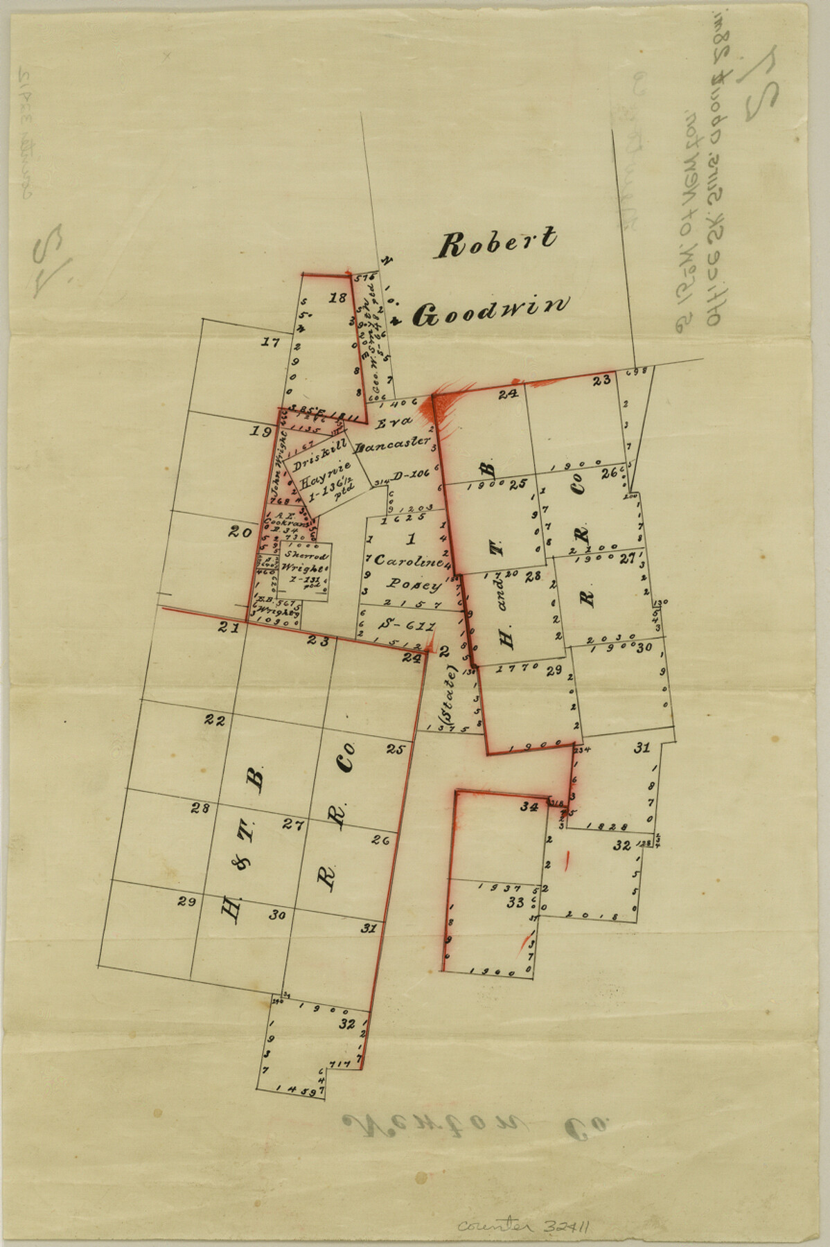
Newton County Sketch File 27
[Office sketch of area between the H. T. & B. R.R. Co. and H. & T. C. R.R. Co. Blocks just south of the Robert Goodwin league in the south part of the county]
-
Map/Doc
32411
-
Collection
General Map Collection
-
Counties
Newton
-
Subjects
Surveying Sketch File
-
Height x Width
13.0 x 8.6 inches
33.0 x 21.8 cm
-
Medium
paper, manuscript
Part of: General Map Collection
San Patricio County NRC Article 33.136 Sketch 4

Print $3.00
- Digital $50.00
San Patricio County NRC Article 33.136 Sketch 4
Size 11.0 x 17.0 inches
Map/Doc 94695
Freestone County Sketch File 19

Print $8.00
- Digital $50.00
Freestone County Sketch File 19
Size 12.4 x 8.1 inches
Map/Doc 23078
Nacogdoches County Working Sketch 7

Print $20.00
- Digital $50.00
Nacogdoches County Working Sketch 7
1962
Size 24.1 x 21.7 inches
Map/Doc 71223
Leon County Rolled Sketch 16

Print $40.00
- Digital $50.00
Leon County Rolled Sketch 16
1981
Size 42.8 x 65.3 inches
Map/Doc 9433

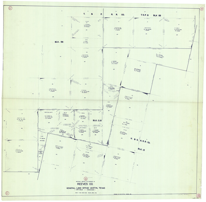
Reeves County Working Sketch 19
Print $20.00
- Digital $50.00
Reeves County Working Sketch 19
1962
Size 42.3 x 42.7 inches
Map/Doc 63462
Pecos County Rolled Sketch ANL

Print $20.00
- Digital $50.00
Pecos County Rolled Sketch ANL
Size 31.5 x 38.4 inches
Map/Doc 7308
Harbor of Brazos Santiago, Texas

Print $20.00
- Digital $50.00
Harbor of Brazos Santiago, Texas
1887
Size 27.1 x 18.3 inches
Map/Doc 72994
Val Verde County Working Sketch 114

Print $20.00
- Digital $50.00
Val Verde County Working Sketch 114
1993
Size 25.9 x 40.9 inches
Map/Doc 72249
Goliad County Working Sketch 5

Print $20.00
- Digital $50.00
Goliad County Working Sketch 5
1925
Size 39.9 x 36.5 inches
Map/Doc 63195
Clay County Sketch File 42

Print $20.00
- Digital $50.00
Clay County Sketch File 42
Size 22.8 x 31.0 inches
Map/Doc 11093
Falls County Sketch File 32

Print $20.00
- Digital $50.00
Falls County Sketch File 32
Size 36.3 x 24.7 inches
Map/Doc 11468
You may also like
Map of Colorado County

Print $20.00
- Digital $50.00
Map of Colorado County
1871
Size 18.4 x 19.1 inches
Map/Doc 4594
Sherman County

Print $20.00
- Digital $50.00
Sherman County
1902
Size 41.0 x 36.7 inches
Map/Doc 63035
Map of Corpus Christi Bay in Nueces County Showing Subdivision for Mineral Development

Print $40.00
- Digital $50.00
Map of Corpus Christi Bay in Nueces County Showing Subdivision for Mineral Development
1950
Size 49.3 x 37.2 inches
Map/Doc 3129
Dawson County Sketch File 3a

Print $12.00
- Digital $50.00
Dawson County Sketch File 3a
Size 12.9 x 8.3 inches
Map/Doc 20503
Surveyor's Watercourse Report 2

Print $42.00
Surveyor's Watercourse Report 2
2025
Size 11.0 x 8.5 inches
Map/Doc 97512
Fayette County Boundary File 1

Print $2.00
- Digital $50.00
Fayette County Boundary File 1
Size 11.1 x 8.7 inches
Map/Doc 53330
Brown County Working Sketch 2

Print $20.00
- Digital $50.00
Brown County Working Sketch 2
1919
Size 17.0 x 17.5 inches
Map/Doc 67767
Edwards County Working Sketch 51

Print $20.00
- Digital $50.00
Edwards County Working Sketch 51
1950
Size 21.8 x 22.7 inches
Map/Doc 68927
Edwards County Working Sketch 140

Print $20.00
- Digital $50.00
Edwards County Working Sketch 140
2014
Size 36.1 x 41.1 inches
Map/Doc 93665
Jack County Working Sketch 13

Print $20.00
- Digital $50.00
Jack County Working Sketch 13
1975
Size 25.5 x 35.8 inches
Map/Doc 66439
Montague County Rolled Sketch 5

Print $20.00
- Digital $50.00
Montague County Rolled Sketch 5
Size 27.3 x 30.2 inches
Map/Doc 6789
