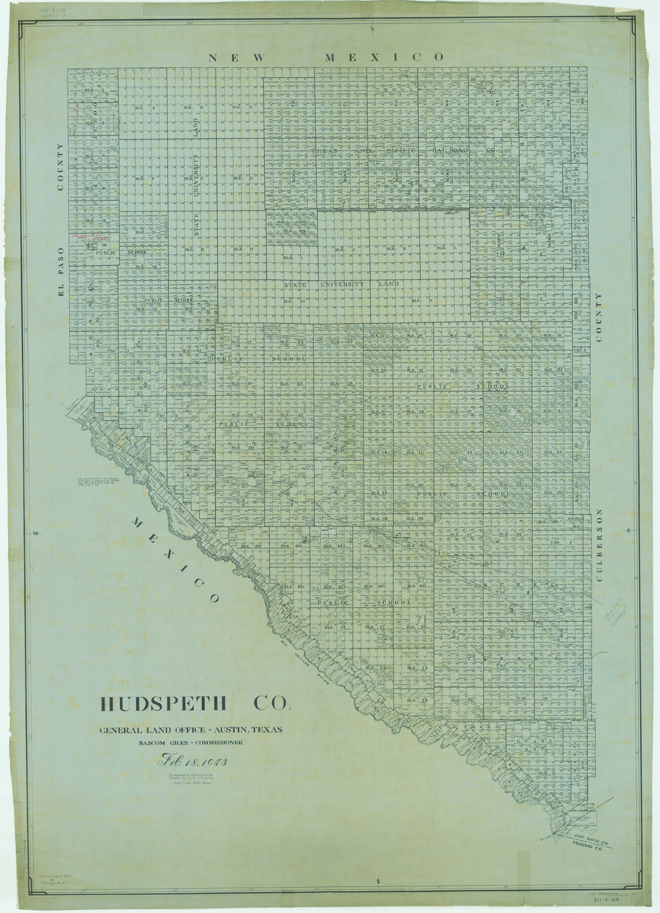
Hudspeth Co.
RM-3-115
-
Map/Doc
1861
-
Collection
General Map Collection
-
Object Dates
1943/2/18 (Creation Date)
-
People and Organizations
Texas General Land Office (Publisher)
G.C. Morriss (Compiler)
Victor E. Sterzing (Draftsman)
-
Counties
Hudspeth
-
Subjects
County
-
Height x Width
53.7 x 38.8 inches
136.4 x 98.6 cm
-
Comments
Traced July 3, 1943 by Tommye Buie.
Part of: General Map Collection
Medina County Sketch File 4

Print $6.00
- Digital $50.00
Medina County Sketch File 4
Size 10.0 x 7.4 inches
Map/Doc 31447
La Salle County Sketch File 7

Print $22.00
- Digital $50.00
La Salle County Sketch File 7
Size 8.0 x 12.3 inches
Map/Doc 29456
Guadalupe River, Watershed [of the Guadalupe River]
![65059, Guadalupe River, Watershed [of the Guadalupe River], General Map Collection](https://historictexasmaps.com/wmedia_w700/maps/65059-GC.tif.jpg)
Print $6.00
- Digital $50.00
Guadalupe River, Watershed [of the Guadalupe River]
1925
Size 30.1 x 33.4 inches
Map/Doc 65059
Polk County Sketch File 3

Print $10.00
- Digital $50.00
Polk County Sketch File 3
1848
Size 8.5 x 7.6 inches
Map/Doc 34122
Webb County Sketch File 50-1

Print $8.00
- Digital $50.00
Webb County Sketch File 50-1
1943
Size 14.5 x 8.9 inches
Map/Doc 39833
Aransas County Rolled Sketch 3

Print $20.00
- Digital $50.00
Aransas County Rolled Sketch 3
Size 20.9 x 26.5 inches
Map/Doc 77188
Schleicher County Sketch File 38

Print $20.00
- Digital $50.00
Schleicher County Sketch File 38
Size 19.1 x 21.7 inches
Map/Doc 12311
Tyler County Sketch File 13

Print $6.00
- Digital $50.00
Tyler County Sketch File 13
1857
Size 8.7 x 13.0 inches
Map/Doc 38653
Briscoe County Boundary File 6

Print $4.00
- Digital $50.00
Briscoe County Boundary File 6
Size 10.6 x 8.1 inches
Map/Doc 50804
La Salle County Rolled Sketch 23A

Print $225.00
- Digital $50.00
La Salle County Rolled Sketch 23A
1956
Size 10.0 x 15.6 inches
Map/Doc 46481
Flight Mission No. DIX-3P, Frame 59, Aransas County

Print $20.00
- Digital $50.00
Flight Mission No. DIX-3P, Frame 59, Aransas County
1956
Size 17.6 x 21.1 inches
Map/Doc 83761
Culberson County Working Sketch 23

Print $20.00
- Digital $50.00
Culberson County Working Sketch 23
1945
Size 38.3 x 44.7 inches
Map/Doc 68476
You may also like
No. 3 Chart of Channel connecting Corpus Christi Bay with Aransas Bay, Texas

Print $20.00
- Digital $50.00
No. 3 Chart of Channel connecting Corpus Christi Bay with Aransas Bay, Texas
1848
Size 18.3 x 27.9 inches
Map/Doc 72777
Childress Co.

Print $20.00
- Digital $50.00
Childress Co.
1978
Size 46.2 x 35.0 inches
Map/Doc 73105

Real County Rolled Sketch 18

Print $20.00
- Digital $50.00
Real County Rolled Sketch 18
Size 22.0 x 28.0 inches
Map/Doc 7463
Moore County Rolled Sketch 7

Print $20.00
- Digital $50.00
Moore County Rolled Sketch 7
1911
Size 36.0 x 29.3 inches
Map/Doc 6826
Controlled Mosaic by Jack Amman Photogrammetric Engineers, Inc - Sheet 34

Print $20.00
- Digital $50.00
Controlled Mosaic by Jack Amman Photogrammetric Engineers, Inc - Sheet 34
1954
Size 20.0 x 24.0 inches
Map/Doc 83487
Kent County Boundary File 4

Print $20.00
- Digital $50.00
Kent County Boundary File 4
Size 8.8 x 4.6 inches
Map/Doc 55828
Brazoria County Working Sketch 32

Print $20.00
- Digital $50.00
Brazoria County Working Sketch 32
1979
Size 15.8 x 36.9 inches
Map/Doc 67517
Reeves County Working Sketch 11

Print $20.00
- Digital $50.00
Reeves County Working Sketch 11
1957
Size 27.7 x 36.9 inches
Map/Doc 63454
Harris County Working Sketch Graphic Index, Sheet 2 (Sketches 69 to Most Recent)

Print $20.00
- Digital $50.00
Harris County Working Sketch Graphic Index, Sheet 2 (Sketches 69 to Most Recent)
1940
Size 38.5 x 46.2 inches
Map/Doc 76569
Loving County Working Sketch 11

Print $40.00
- Digital $50.00
Loving County Working Sketch 11
1957
Size 21.6 x 50.9 inches
Map/Doc 70644
Flight Mission No. CRC-5R, Frame 26, Chambers County

Print $20.00
- Digital $50.00
Flight Mission No. CRC-5R, Frame 26, Chambers County
1956
Size 18.6 x 22.5 inches
Map/Doc 84948