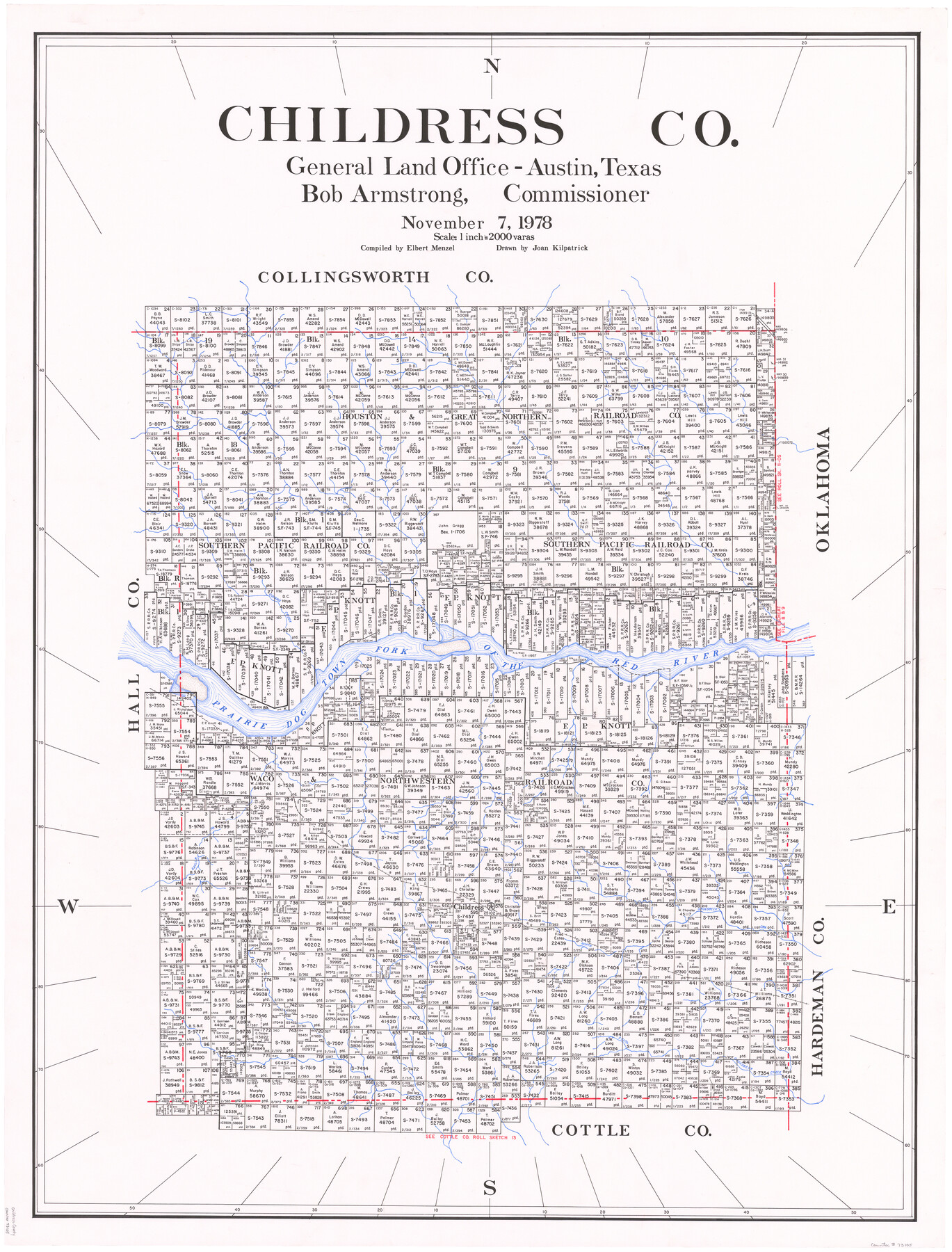
Childress Co.
-
Map/Doc
73105
-
Collection
General Map Collection
-
Object Dates
11/7/1978 (Creation Date)
-
People and Organizations
Elbert Menzel (Compiler)
Bob Armstrong (GLO Commissioner)
Joan Kilpatrick (Draftsman)
-
Counties
Childress
-
Subjects
County
-
Height x Width
46.2 x 35.0 inches
117.4 x 88.9 cm
-
Scale
1" = 2000 varas
-
Comments
Leroy lettered.
-
Features
Cousins Creek
Prairie Dog Town Fork of the Red River
FW&DC
Baylor Creek
North Groesbeck Creek
Childress
South Groesbeck Creek
Part of: General Map Collection
Falls County Sketch File 9

Print $4.00
- Digital $50.00
Falls County Sketch File 9
Size 13.0 x 8.5 inches
Map/Doc 22343
Gonzales County Sketch File 11

Print $4.00
- Digital $50.00
Gonzales County Sketch File 11
1842
Size 12.8 x 7.9 inches
Map/Doc 24392
Reeves County Rolled Sketch 25

Print $20.00
- Digital $50.00
Reeves County Rolled Sketch 25
1982
Size 22.3 x 20.6 inches
Map/Doc 7494
Oldham County Boundary File 2

Print $10.00
- Digital $50.00
Oldham County Boundary File 2
Size 14.2 x 8.6 inches
Map/Doc 57766
Pecos County Rolled Sketch 70A

Print $20.00
- Digital $50.00
Pecos County Rolled Sketch 70A
1929
Size 46.7 x 20.8 inches
Map/Doc 9709
Jasper County Working Sketch 9

Print $20.00
- Digital $50.00
Jasper County Working Sketch 9
1917
Size 21.0 x 14.3 inches
Map/Doc 66471
Plat of Jasper, Sabine, San Augustine, Shelby, Harrison and South Part of Nacogdoches Counties

Print $2.00
- Digital $50.00
Plat of Jasper, Sabine, San Augustine, Shelby, Harrison and South Part of Nacogdoches Counties
1841
Size 13.7 x 9.2 inches
Map/Doc 3174
Clay County Sketch File 48

Print $26.00
- Digital $50.00
Clay County Sketch File 48
1919
Size 14.2 x 8.6 inches
Map/Doc 18487
Kimble County Working Sketch 31

Print $20.00
- Digital $50.00
Kimble County Working Sketch 31
1944
Size 34.8 x 34.6 inches
Map/Doc 70099
Harrison County Sketch File 2

Print $4.00
- Digital $50.00
Harrison County Sketch File 2
1853
Size 8.1 x 9.9 inches
Map/Doc 26034
Sketch K Showing the Progress of the Survey of the Columbia River, Oregon

Print $20.00
- Digital $50.00
Sketch K Showing the Progress of the Survey of the Columbia River, Oregon
1852
Size 9.8 x 12.7 inches
Map/Doc 97237
Coryell County Boundary File 3

Print $14.00
- Digital $50.00
Coryell County Boundary File 3
Size 13.2 x 8.2 inches
Map/Doc 51907
You may also like
[Block H, E. L. & R. R. Block C-41, and Public School Lands]
![91386, [Block H, E. L. & R. R. Block C-41, and Public School Lands], Twichell Survey Records](https://historictexasmaps.com/wmedia_w700/maps/91386-1.tif.jpg)
Print $20.00
- Digital $50.00
[Block H, E. L. & R. R. Block C-41, and Public School Lands]
1951
Size 24.5 x 18.4 inches
Map/Doc 91386

Swisher County Sketch File 8

Print $20.00
- Digital $50.00
Swisher County Sketch File 8
1907
Size 19.2 x 16.3 inches
Map/Doc 12405
Trinity River, Malloy Bridge Sheet

Print $20.00
- Digital $50.00
Trinity River, Malloy Bridge Sheet
1922
Size 41.7 x 40.2 inches
Map/Doc 65189
Scurry County Working Sketch 7

Print $20.00
- Digital $50.00
Scurry County Working Sketch 7
1971
Size 33.5 x 29.0 inches
Map/Doc 63836
Sutton County Sketch File 60

Print $20.00
- Digital $50.00
Sutton County Sketch File 60
Size 34.6 x 43.9 inches
Map/Doc 10378
Stonewall County Rolled Sketch 27

Print $20.00
- Digital $50.00
Stonewall County Rolled Sketch 27
Size 31.0 x 44.2 inches
Map/Doc 9966
[Sketch for Mineral Application 16787 - Pecos River Bed, A. T. Freet]
![65632, [Sketch for Mineral Application 16787 - Pecos River Bed, A. T. Freet], General Map Collection](https://historictexasmaps.com/wmedia_w700/maps/65632-1.tif.jpg)
Print $40.00
- Digital $50.00
[Sketch for Mineral Application 16787 - Pecos River Bed, A. T. Freet]
Size 70.8 x 18.9 inches
Map/Doc 65632
Hale County Boundary File 10

Print $62.00
- Digital $50.00
Hale County Boundary File 10
Size 37.9 x 9.4 inches
Map/Doc 54145
Trinity River, Kimbrough Lake Sheet

Print $4.00
- Digital $50.00
Trinity River, Kimbrough Lake Sheet
1929
Size 26.0 x 19.4 inches
Map/Doc 65225
Atascosa County Rolled Sketch 25

Print $20.00
- Digital $50.00
Atascosa County Rolled Sketch 25
Size 25.2 x 20.5 inches
Map/Doc 93551
Kerr County Boundary File 55

Print $64.00
- Digital $50.00
Kerr County Boundary File 55
Size 8.7 x 3.5 inches
Map/Doc 64826