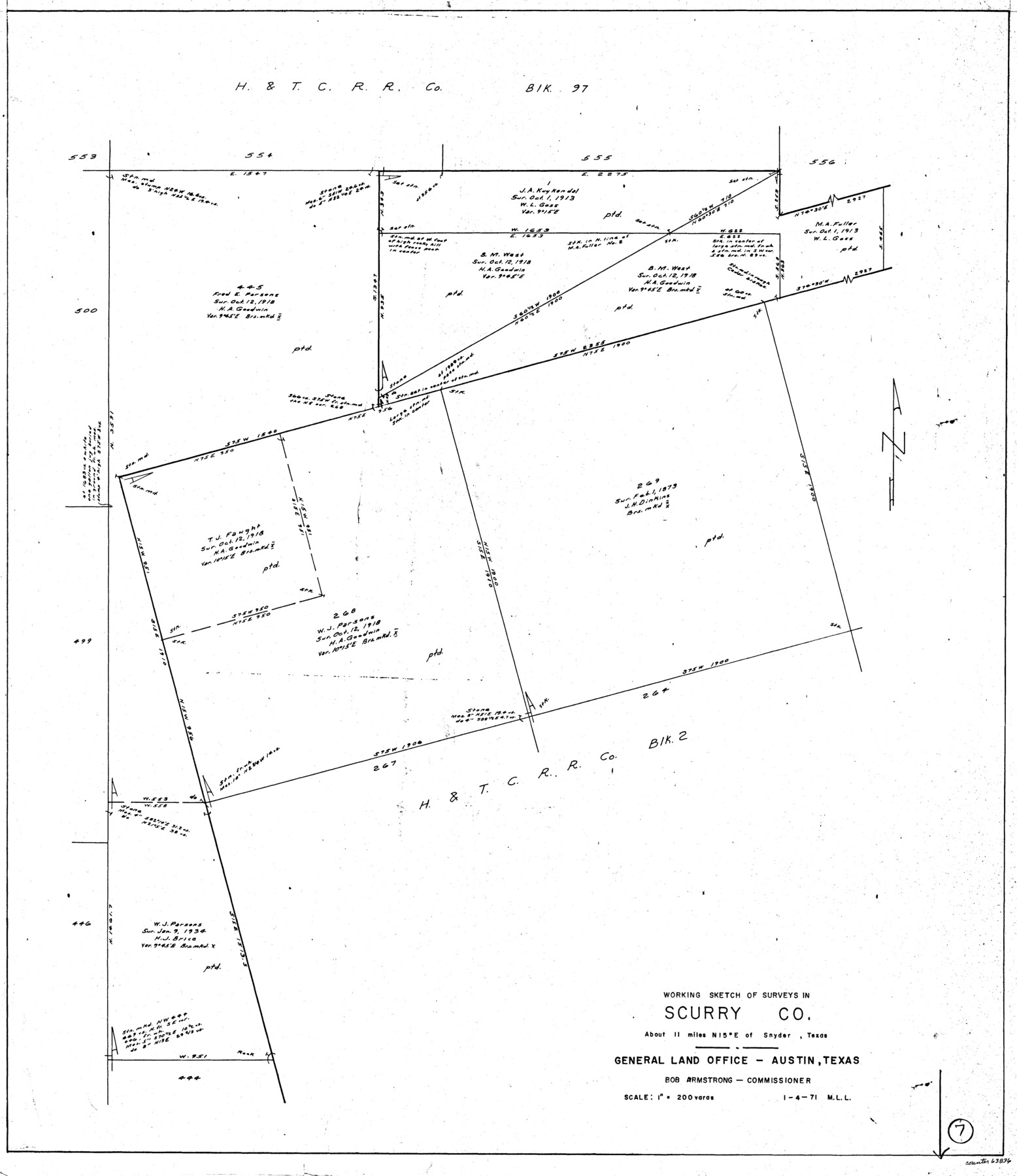
Scurry County Working Sketch 7
-
Map/Doc
63836
-
Collection
General Map Collection
-
Object Dates
1/4/1971 (Creation Date)
-
People and Organizations
M. L. Liles (Draftsman)
-
Counties
Scurry
-
Subjects
Surveying Working Sketch
-
Height x Width
33.5 x 29.0 inches
85.1 x 73.7 cm
-
Scale
1" = 200 varas
Part of: General Map Collection
Haskell County Sketch File 21

Print $20.00
- Digital $50.00
Haskell County Sketch File 21
1935
Size 30.2 x 20.3 inches
Map/Doc 11744
Current Miscellaneous File 39

Print $20.00
- Digital $50.00
Current Miscellaneous File 39
Size 11.2 x 8.8 inches
Map/Doc 73962
Map of the Straits of Florida and Gulf of Mexico

Print $20.00
- Digital $50.00
Map of the Straits of Florida and Gulf of Mexico
1851
Size 18.3 x 27.4 inches
Map/Doc 72675
Erath County Sketch File 33

Print $11.00
- Digital $50.00
Erath County Sketch File 33
1962
Size 14.4 x 8.8 inches
Map/Doc 22315
Orange County Rolled Sketch 29

Print $20.00
- Digital $50.00
Orange County Rolled Sketch 29
1960
Size 25.9 x 37.2 inches
Map/Doc 7187
Lampasas County Working Sketch 15

Print $20.00
- Digital $50.00
Lampasas County Working Sketch 15
1975
Size 28.5 x 23.8 inches
Map/Doc 70292

Webb County Working Sketch 18

Print $20.00
- Digital $50.00
Webb County Working Sketch 18
1923
Size 18.6 x 12.8 inches
Map/Doc 72383
Flight Mission No. CRC-2R, Frame 136, Chambers County

Print $20.00
- Digital $50.00
Flight Mission No. CRC-2R, Frame 136, Chambers County
1956
Size 18.7 x 22.4 inches
Map/Doc 84752
Maps of Gulf Intracoastal Waterway, Texas - Sabine River to the Rio Grande and connecting waterways including ship channels

Print $20.00
- Digital $50.00
Maps of Gulf Intracoastal Waterway, Texas - Sabine River to the Rio Grande and connecting waterways including ship channels
1966
Size 14.5 x 22.3 inches
Map/Doc 61921
Sketch I: Showing the Progress of the Survey in Section No. 9 [Galveston Bay]
![97133, Sketch I: Showing the Progress of the Survey in Section No. 9 [Galveston Bay], General Map Collection](https://historictexasmaps.com/wmedia_w700/maps/97133.tif.jpg)
Print $20.00
- Digital $50.00
Sketch I: Showing the Progress of the Survey in Section No. 9 [Galveston Bay]
1852
Size 9.4 x 13.4 inches
Map/Doc 97133
Dimmit County Sketch File 60

Print $4.00
- Digital $50.00
Dimmit County Sketch File 60
1991
Size 14.2 x 8.8 inches
Map/Doc 21206
You may also like
Sutton County Sketch File 39

Print $20.00
- Digital $50.00
Sutton County Sketch File 39
1939
Size 16.8 x 24.2 inches
Map/Doc 12389
Kimble County Rolled Sketch 17

Print $20.00
- Digital $50.00
Kimble County Rolled Sketch 17
Size 19.7 x 20.5 inches
Map/Doc 6509
Shallowater Well Field Survey

Print $40.00
- Digital $50.00
Shallowater Well Field Survey
Size 61.8 x 43.7 inches
Map/Doc 89900
Dickens County Sketch File 5

Print $40.00
- Digital $50.00
Dickens County Sketch File 5
Size 24.3 x 18.1 inches
Map/Doc 75996
Crockett County Working Sketch 84

Print $40.00
- Digital $50.00
Crockett County Working Sketch 84
1976
Size 49.4 x 26.2 inches
Map/Doc 68417
Ed F. Mann and Ed Liedtke's Subdivision of Leagues 22 and 23 McCulloch County School Land Hockley County, Texas

Print $20.00
- Digital $50.00
Ed F. Mann and Ed Liedtke's Subdivision of Leagues 22 and 23 McCulloch County School Land Hockley County, Texas
Size 25.9 x 22.0 inches
Map/Doc 92212
Duval County Sketch File 6c

Print $5.00
- Digital $50.00
Duval County Sketch File 6c
1875
Size 8.2 x 11.0 inches
Map/Doc 21292
Texas, Brazos River, Freeport

Print $40.00
- Digital $50.00
Texas, Brazos River, Freeport
1933
Size 28.4 x 48.3 inches
Map/Doc 69994
North Part of El Paso Co.

Print $20.00
- Digital $50.00
North Part of El Paso Co.
1977
Size 36.5 x 47.8 inches
Map/Doc 95490
Flight Mission No. BRA-6M, Frame 84, Jefferson County

Print $20.00
- Digital $50.00
Flight Mission No. BRA-6M, Frame 84, Jefferson County
1953
Size 18.6 x 22.4 inches
Map/Doc 85428
Kimble County Rolled Sketch 23

Print $20.00
- Digital $50.00
Kimble County Rolled Sketch 23
Size 16.0 x 21.0 inches
Map/Doc 6513
