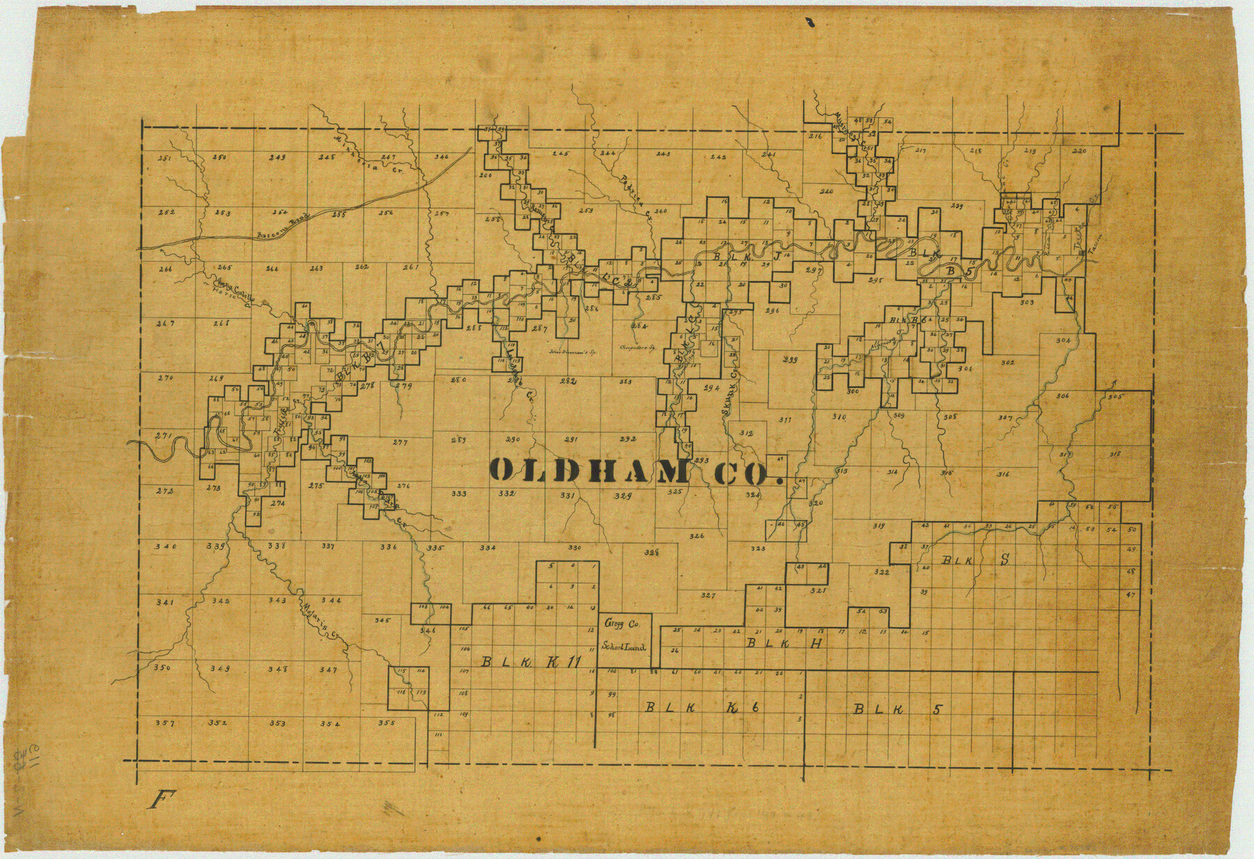
Oldham Co.
N-2-119
-
Map/Doc
75985
-
Collection
General Map Collection
-
Counties
Oldham
-
Subjects
County
-
Height x Width
19.4 x 28.3 inches
49.3 x 71.9 cm
-
Comments
Capitol land map.
Part of: General Map Collection
Erath County Sketch File 21

Print $6.00
- Digital $50.00
Erath County Sketch File 21
Size 9.9 x 12.2 inches
Map/Doc 22302
Uvalde County Sketch File A

Print $40.00
- Digital $50.00
Uvalde County Sketch File A
1912
Size 23.0 x 18.0 inches
Map/Doc 12537
Flight Mission No. DQN-2K, Frame 147, Calhoun County

Print $20.00
- Digital $50.00
Flight Mission No. DQN-2K, Frame 147, Calhoun County
1953
Size 19.0 x 22.6 inches
Map/Doc 84316
Flight Mission No. BRE-2P, Frame 96, Nueces County

Print $20.00
- Digital $50.00
Flight Mission No. BRE-2P, Frame 96, Nueces County
1956
Size 18.4 x 22.3 inches
Map/Doc 86781
Comal County Working Sketch 19

Print $20.00
- Digital $50.00
Comal County Working Sketch 19
2006
Size 18.8 x 29.0 inches
Map/Doc 83094
[Sketch for Mineral Application 16700 - Pecos River Bed]
![2807, [Sketch for Mineral Application 16700 - Pecos River Bed], General Map Collection](https://historictexasmaps.com/wmedia_w700/maps/2807.tif.jpg)
Print $20.00
- Digital $50.00
[Sketch for Mineral Application 16700 - Pecos River Bed]
1927
Size 32.9 x 15.3 inches
Map/Doc 2807
Harris County Working Sketch 129

Print $20.00
- Digital $50.00
Harris County Working Sketch 129
2014
Size 24.2 x 19.1 inches
Map/Doc 93711
[Sketch for Mineral Application 16787 - Pecos River Bed, A. T. Freet]
![65632, [Sketch for Mineral Application 16787 - Pecos River Bed, A. T. Freet], General Map Collection](https://historictexasmaps.com/wmedia_w700/maps/65632-1.tif.jpg)
Print $40.00
- Digital $50.00
[Sketch for Mineral Application 16787 - Pecos River Bed, A. T. Freet]
Size 70.8 x 18.9 inches
Map/Doc 65632
Houston County Working Sketch 31

Print $20.00
- Digital $50.00
Houston County Working Sketch 31
1987
Size 23.9 x 37.3 inches
Map/Doc 66261
Stephens County Working Sketch 25

Print $20.00
- Digital $50.00
Stephens County Working Sketch 25
1976
Size 37.4 x 32.3 inches
Map/Doc 63968
Gray County Boundary File 3

Print $40.00
- Digital $50.00
Gray County Boundary File 3
Size 14.2 x 8.8 inches
Map/Doc 53854
Chambers County NRC Article 33.136 Sketch 6

Print $58.00
- Digital $50.00
Chambers County NRC Article 33.136 Sketch 6
2007
Size 11.0 x 8.5 inches
Map/Doc 88802
You may also like
Flight Mission No. BRA-7M, Frame 10, Jefferson County

Print $20.00
- Digital $50.00
Flight Mission No. BRA-7M, Frame 10, Jefferson County
1953
Size 18.7 x 22.4 inches
Map/Doc 85461
Treaty to Resolve Pending Boundary Differences and Maintain the Rio Grande and Colorado River as the International Boundary Between the United States of American and Mexico

Print $20.00
- Digital $50.00
Treaty to Resolve Pending Boundary Differences and Maintain the Rio Grande and Colorado River as the International Boundary Between the United States of American and Mexico
1970
Size 11.1 x 35.8 inches
Map/Doc 83102
Map No. 1 - Rio Bravo del Norte section of boundary between the United States & Mexico agreed upon by the Joint Commission under the Treaty of Guadalupe Hidalgo

Print $20.00
- Digital $50.00
Map No. 1 - Rio Bravo del Norte section of boundary between the United States & Mexico agreed upon by the Joint Commission under the Treaty of Guadalupe Hidalgo
1852
Size 18.3 x 27.0 inches
Map/Doc 72863
Bandera County Rolled Sketch 1

Print $20.00
- Digital $50.00
Bandera County Rolled Sketch 1
1945
Size 16.5 x 16.0 inches
Map/Doc 5113

Flight Mission No. DCL-6C, Frame 96, Kenedy County

Print $20.00
- Digital $50.00
Flight Mission No. DCL-6C, Frame 96, Kenedy County
1943
Size 18.6 x 22.4 inches
Map/Doc 85926
Garza County Sketch File D

Print $20.00
- Digital $50.00
Garza County Sketch File D
1901
Size 18.4 x 12.2 inches
Map/Doc 11550
Dallas County Boundary File 4

Print $38.00
- Digital $50.00
Dallas County Boundary File 4
Size 8.9 x 3.9 inches
Map/Doc 52123
Lynn County Rolled Sketch 11

Print $20.00
- Digital $50.00
Lynn County Rolled Sketch 11
1940
Size 14.2 x 16.4 inches
Map/Doc 6647
Travis County Sketch File 72

Print $4.00
- Digital $50.00
Travis County Sketch File 72
1850
Size 12.7 x 8.4 inches
Map/Doc 38460
The Republic County of Shelby. January 16, 1843

Print $20.00
The Republic County of Shelby. January 16, 1843
2020
Size 20.0 x 21.7 inches
Map/Doc 96285
Flight Mission No. DAG-18K, Frame 76, Matagorda County

Print $20.00
- Digital $50.00
Flight Mission No. DAG-18K, Frame 76, Matagorda County
1952
Size 17.5 x 22.1 inches
Map/Doc 86369