Treaty to Resolve Pending Boundary Differences and Maintain the Rio Grande and Colorado River as the International Boundary Between the United States of American and Mexico
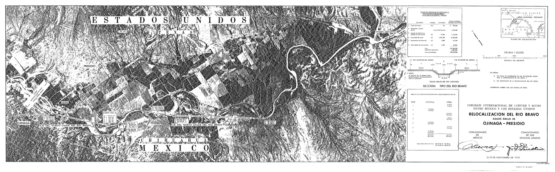
Comision Internacional de Limites y Aguas Entre Mexico y Los Estados Unidos Relocalizacion del Rio Bravo Aguas Abajo de Ojinaga - Presidio
-
Map/Doc
83102
-
Collection
General Map Collection
-
Object Dates
1970/12/12 (Creation Date)
-
People and Organizations
United States Department of State (Publisher)
U. S. Government Printing Office (Printer)
-
Subjects
Texas Boundaries
-
Height x Width
11.1 x 35.8 inches
28.2 x 90.9 cm
-
Medium
sketch
Part of: General Map Collection
Travis County Sketch File 73

Print $8.00
- Digital $50.00
Travis County Sketch File 73
1848
Size 12.8 x 8.3 inches
Map/Doc 38464
[Sketch for Mineral Application 26501 - Sabine River, T. A. Oldhausen]
![2835, [Sketch for Mineral Application 26501 - Sabine River, T. A. Oldhausen], General Map Collection](https://historictexasmaps.com/wmedia_w700/maps/2835.tif.jpg)
Print $20.00
- Digital $50.00
[Sketch for Mineral Application 26501 - Sabine River, T. A. Oldhausen]
1931
Size 24.6 x 36.6 inches
Map/Doc 2835
Navarro County

Print $40.00
- Digital $50.00
Navarro County
1924
Size 41.1 x 48.2 inches
Map/Doc 77382
Right of Way & Track Map, St. Louis, Brownsville & Mexico Ry. operated by St. Louis, Brownsville & Mexico Ry. Co.

Print $40.00
- Digital $50.00
Right of Way & Track Map, St. Louis, Brownsville & Mexico Ry. operated by St. Louis, Brownsville & Mexico Ry. Co.
1919
Size 25.6 x 57.1 inches
Map/Doc 64616
Right of Way and Track Map of The Missouri, Kansas & Texas Railway of Texas

Print $40.00
- Digital $50.00
Right of Way and Track Map of The Missouri, Kansas & Texas Railway of Texas
1918
Size 25.2 x 51.6 inches
Map/Doc 64530
Survey of all that part of lots 6, 7, and the north 1/2 of 20 foot alley lying south of said lots 6 and 7, all of lots 8, 9, 10, the east one half of lot 11, all of lot 13, lying south and adjacent to the southerly seawall right-of-way line

Print $2.00
- Digital $50.00
Survey of all that part of lots 6, 7, and the north 1/2 of 20 foot alley lying south of said lots 6 and 7, all of lots 8, 9, 10, the east one half of lot 11, all of lot 13, lying south and adjacent to the southerly seawall right-of-way line
1969
Size 17.0 x 15.3 inches
Map/Doc 73624
Trinity County Sketch File 4

Print $24.00
- Digital $50.00
Trinity County Sketch File 4
1858
Size 8.4 x 7.7 inches
Map/Doc 38501
Monterey Harbor, California

Print $20.00
- Digital $50.00
Monterey Harbor, California
1852
Size 15.7 x 13.8 inches
Map/Doc 97230
Fisher County Sketch File 23

Print $12.00
- Digital $50.00
Fisher County Sketch File 23
1875
Size 10.8 x 8.2 inches
Map/Doc 22660
Hardin County Sketch File A

Print $20.00
- Digital $50.00
Hardin County Sketch File A
Size 19.3 x 33.4 inches
Map/Doc 11644

Flight Mission No. BQR-22K, Frame 34, Brazoria County

Print $20.00
- Digital $50.00
Flight Mission No. BQR-22K, Frame 34, Brazoria County
1953
Size 18.7 x 22.5 inches
Map/Doc 84118
You may also like
Presidio County Sketch File B

Print $20.00
- Digital $50.00
Presidio County Sketch File B
Size 25.2 x 21.3 inches
Map/Doc 11701
Flight Mission No. DCL-7C, Frame 28, Kenedy County

Print $20.00
- Digital $50.00
Flight Mission No. DCL-7C, Frame 28, Kenedy County
1943
Size 15.4 x 15.4 inches
Map/Doc 86020
Ochiltree County

Print $20.00
- Digital $50.00
Ochiltree County
1878
Size 19.2 x 17.5 inches
Map/Doc 3924
[Pencil sketch around the Fred Mohler survey 19]
![92994, [Pencil sketch around the Fred Mohler survey 19], Twichell Survey Records](https://historictexasmaps.com/wmedia_w700/maps/92994-1.tif.jpg)
Print $3.00
- Digital $50.00
[Pencil sketch around the Fred Mohler survey 19]
Size 14.1 x 10.4 inches
Map/Doc 92994
Jack County Sketch File 13

Print $4.00
- Digital $50.00
Jack County Sketch File 13
Size 10.3 x 8.0 inches
Map/Doc 27537
Map of Williamson County

Print $20.00
- Digital $50.00
Map of Williamson County
1876
Size 21.2 x 28.6 inches
Map/Doc 4152
Wichita County Sketch File I

Print $4.00
- Digital $50.00
Wichita County Sketch File I
1885
Size 10.3 x 8.2 inches
Map/Doc 40091
Concho County Working Sketch 19

Print $20.00
- Digital $50.00
Concho County Working Sketch 19
1957
Size 27.3 x 24.9 inches
Map/Doc 68201
Limestone County Sketch File 14

Print $4.00
- Digital $50.00
Limestone County Sketch File 14
1883
Size 10.7 x 8.2 inches
Map/Doc 30179
Kenedy County Aerial Photograph Index Sheet 1

Print $20.00
- Digital $50.00
Kenedy County Aerial Photograph Index Sheet 1
1943
Size 23.3 x 19.5 inches
Map/Doc 83713
Young County Rolled Sketch 2

Print $20.00
- Digital $50.00
Young County Rolled Sketch 2
Size 26.2 x 25.0 inches
Map/Doc 8292
Glasscock County Sketch File 14

Print $8.00
- Digital $50.00
Glasscock County Sketch File 14
1935
Size 11.3 x 8.6 inches
Map/Doc 24178