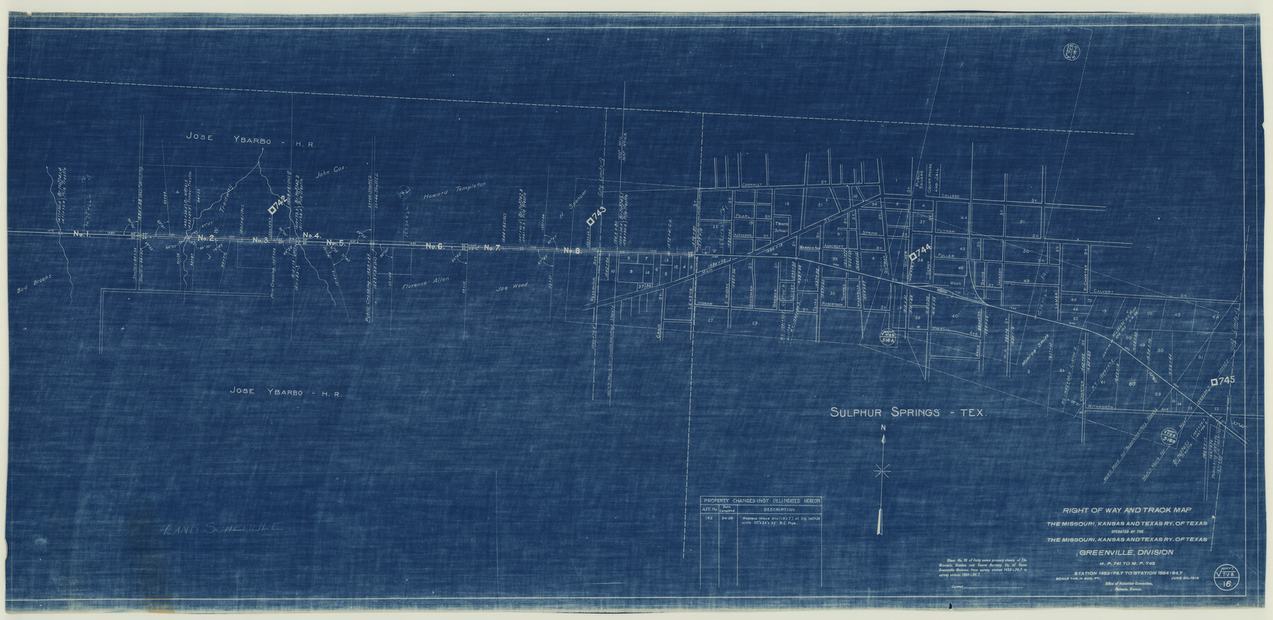
Right of Way and Track Map of The Missouri, Kansas & Texas Railway of Texas
Z-2-162
-
Map/Doc
64530
-
Collection
General Map Collection
-
Object Dates
1918/6/30 (Creation Date)
-
Counties
Hopkins
-
Subjects
Railroads
-
Height x Width
25.2 x 51.6 inches
64.0 x 131.1 cm
-
Medium
blueprint/diazo
-
Scale
1 in. = 400 ft.
-
Comments
Operated by the Missouri, Kansas and Texas Railway of Texas. Greenville Division. See counter nos. 64525 through 64533 for other sheets of the map.
-
Features
Public Square
Ardis Street
Lamar Street
S. Charter Street
Calvert Street
Withworth Avenue
Craig Street
Sulphur Springs
MK&T
Court House & Jail
Fuller Street
College Street
Putnam Street
Spring Street
Connally Street
Travis School
Pearl Street
Katherine Street
Reservoir Avenue
Townes Street
League Street
S. Moore Street
Goodman Street
Brewer Street
Warren Avenue
Ashcroft Street
Ingram Street
Texas Street
Robertson Street
Main Street
Magnolia Street
Quitman Street
Gilmer Street
Depot Street
W. Maxwell Avenue
Wood Street
Gains Street
Jackson Street
Part of: General Map Collection
Flight Mission No. CLL-3N, Frame 19, Willacy County

Print $20.00
- Digital $50.00
Flight Mission No. CLL-3N, Frame 19, Willacy County
1954
Size 18.4 x 22.1 inches
Map/Doc 87085
Sabine County Boundary File 1

Print $96.00
- Digital $50.00
Sabine County Boundary File 1
Size 14.4 x 8.8 inches
Map/Doc 58530
McLennan County Working Sketch 4

Print $20.00
- Digital $50.00
McLennan County Working Sketch 4
1941
Size 19.2 x 27.9 inches
Map/Doc 70697
Dimmit County Rolled Sketch 23

Print $20.00
- Digital $50.00
Dimmit County Rolled Sketch 23
2015
Size 18.1 x 24.3 inches
Map/Doc 93792
Parker County Sketch File 41

Print $4.00
- Digital $50.00
Parker County Sketch File 41
1877
Size 8.9 x 10.6 inches
Map/Doc 33587

Stephens County Working Sketch 37

Print $40.00
- Digital $50.00
Stephens County Working Sketch 37
1983
Size 42.9 x 67.7 inches
Map/Doc 63980
Jeff Davis County Rolled Sketch 12

Print $20.00
- Digital $50.00
Jeff Davis County Rolled Sketch 12
1920
Size 24.8 x 18.1 inches
Map/Doc 6365
Runnels County Rolled Sketch 46

Print $20.00
- Digital $50.00
Runnels County Rolled Sketch 46
1954
Size 32.3 x 38.5 inches
Map/Doc 10622
Flight Mission No. DAG-21K, Frame 131, Matagorda County

Print $20.00
- Digital $50.00
Flight Mission No. DAG-21K, Frame 131, Matagorda County
1952
Size 18.6 x 22.4 inches
Map/Doc 86457
Gonzales County Working Sketch 1

Print $40.00
- Digital $50.00
Gonzales County Working Sketch 1
1913
Size 16.8 x 49.8 inches
Map/Doc 63216

You may also like
Angelina County Sketch File 21b

Print $6.00
- Digital $50.00
Angelina County Sketch File 21b
1889
Size 13.9 x 8.5 inches
Map/Doc 13044
Eastland County Sketch File 7

Print $4.00
- Digital $50.00
Eastland County Sketch File 7
1872
Size 12.6 x 8.5 inches
Map/Doc 21574
The Republic County of San Augustine. December 29, 1845

Print $20.00
The Republic County of San Augustine. December 29, 1845
2020
Size 18.8 x 21.7 inches
Map/Doc 96272
Jim Hogg County Rolled Sketch 5

Print $20.00
- Digital $50.00
Jim Hogg County Rolled Sketch 5
1943
Size 19.9 x 24.1 inches
Map/Doc 6441
Kleberg County Rolled Sketch 10-20

Print $20.00
- Digital $50.00
Kleberg County Rolled Sketch 10-20
1952
Size 35.9 x 35.7 inches
Map/Doc 9368
Baylor County Sketch File Z4

Print $2.00
- Digital $50.00
Baylor County Sketch File Z4
1898
Size 9.3 x 7.2 inches
Map/Doc 14114
[Map of Panhandle Counties]
![91170, [Map of Panhandle Counties], Twichell Survey Records](https://historictexasmaps.com/wmedia_w700/maps/91170-1.tif.jpg)
Print $20.00
- Digital $50.00
[Map of Panhandle Counties]
Size 27.4 x 22.9 inches
Map/Doc 91170
San Saba County Working Sketch 13

Print $20.00
- Digital $50.00
San Saba County Working Sketch 13
1995
Size 42.8 x 32.8 inches
Map/Doc 63801
Baylor County Sketch File 27

Print $4.00
- Digital $50.00
Baylor County Sketch File 27
1895
Size 11.1 x 8.9 inches
Map/Doc 14226
Bosque County Sketch File 31

Print $6.00
- Digital $50.00
Bosque County Sketch File 31
1867
Size 8.5 x 10.5 inches
Map/Doc 14830
Coleman County Sketch File 43

Print $12.00
- Digital $50.00
Coleman County Sketch File 43
1892
Size 9.2 x 8.8 inches
Map/Doc 18775
Webb County Sketch File 56

Print $20.00
- Digital $50.00
Webb County Sketch File 56
1940
Size 18.4 x 20.7 inches
Map/Doc 12651