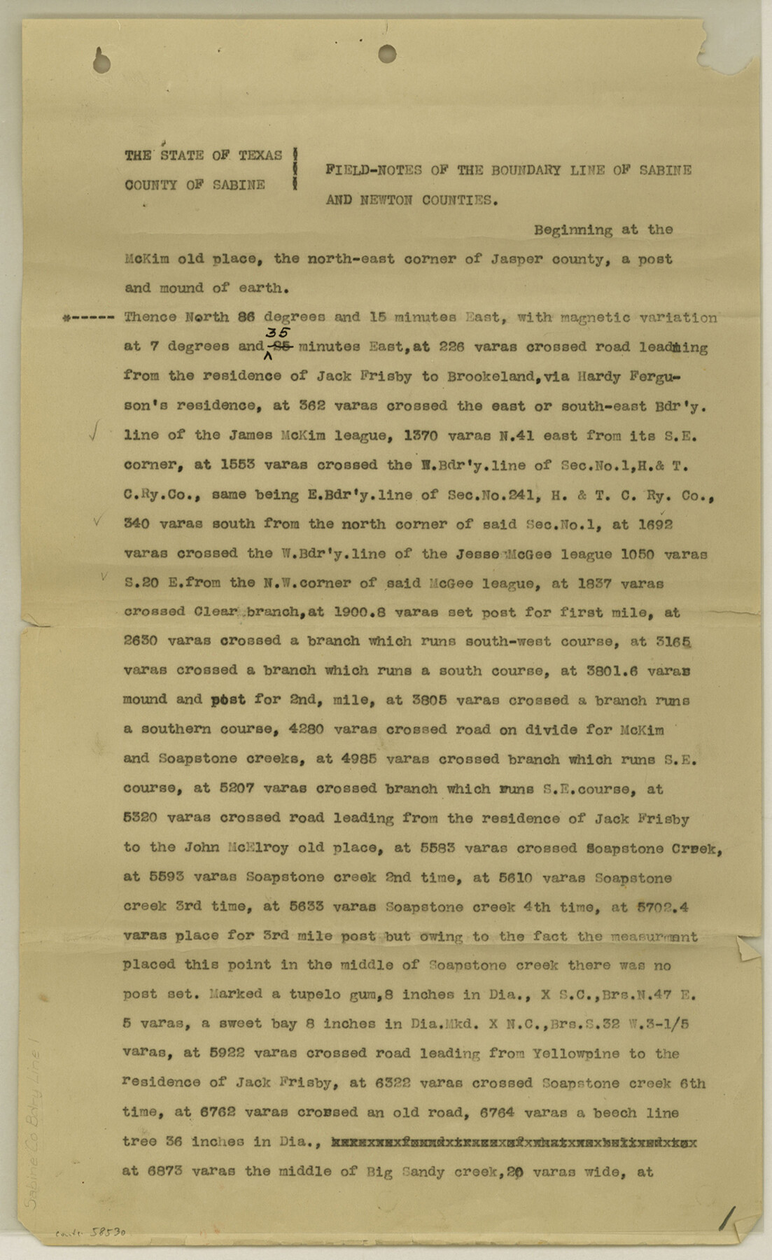
Sabine County Boundary File 1
[Field] Notes of Boundary Line Between Sabine & Newton Counties
-
Map/Doc
58530
-
Collection
General Map Collection
-
Counties
Sabine
-
Subjects
County Boundaries
-
Height x Width
14.4 x 8.8 inches
36.6 x 22.4 cm
Part of: General Map Collection
A Map of the British Empire in America with the French and Spanish Settlements adjacent thereto

Print $20.00
- Digital $50.00
A Map of the British Empire in America with the French and Spanish Settlements adjacent thereto
1733
Size 20.7 x 20.6 inches
Map/Doc 95704
Presidio County Sketch File 62A

Print $20.00
- Digital $50.00
Presidio County Sketch File 62A
Size 14.6 x 20.8 inches
Map/Doc 11717
Hartley County Boundary File 2

Print $52.00
- Digital $50.00
Hartley County Boundary File 2
Size 8.8 x 24.8 inches
Map/Doc 54453
Railroad Track Map, H&TCRRCo., Falls County, Texas

Print $4.00
- Digital $50.00
Railroad Track Map, H&TCRRCo., Falls County, Texas
1918
Size 11.8 x 18.4 inches
Map/Doc 62838
Brazos River, Brazos River Sheet 5

Print $4.00
- Digital $50.00
Brazos River, Brazos River Sheet 5
1926
Size 29.4 x 22.5 inches
Map/Doc 65298
Jefferson County Rolled Sketch 49

Print $40.00
- Digital $50.00
Jefferson County Rolled Sketch 49
1963
Size 30.6 x 57.5 inches
Map/Doc 46415
Val Verde County Sketch File Z12

Print $4.00
- Digital $50.00
Val Verde County Sketch File Z12
1898
Size 11.4 x 8.8 inches
Map/Doc 39140
Cottle County Working Sketch 5

Print $20.00
- Digital $50.00
Cottle County Working Sketch 5
1921
Size 13.5 x 25.5 inches
Map/Doc 68315
Flight Mission No. DAG-24K, Frame 37, Matagorda County

Print $20.00
- Digital $50.00
Flight Mission No. DAG-24K, Frame 37, Matagorda County
1953
Size 18.5 x 22.2 inches
Map/Doc 86524
Sherman County Sketch File 8

Print $61.00
- Digital $50.00
Sherman County Sketch File 8
1993
Size 11.4 x 8.9 inches
Map/Doc 36726
Atascosa County Boundary File 1

Print $14.00
- Digital $50.00
Atascosa County Boundary File 1
Size 12.9 x 8.3 inches
Map/Doc 50153
Webb County Working Sketch Graphic Index - northwest part

Print $40.00
- Digital $50.00
Webb County Working Sketch Graphic Index - northwest part
1984
Size 42.1 x 51.6 inches
Map/Doc 76736
You may also like

Map of Kent County, 1889

Print $20.00
- Digital $50.00
Map of Kent County, 1889
1889
Size 27.2 x 20.2 inches
Map/Doc 3756
Hale County Rolled Sketch 8

Print $20.00
- Digital $50.00
Hale County Rolled Sketch 8
1910
Size 38.0 x 25.9 inches
Map/Doc 6046
Scurry County Sketch File 1

Print $6.00
- Digital $50.00
Scurry County Sketch File 1
Size 14.5 x 9.1 inches
Map/Doc 36560
Upton County Rolled Sketch 48

Print $20.00
- Digital $50.00
Upton County Rolled Sketch 48
1958
Size 27.8 x 27.9 inches
Map/Doc 10694
Colorado County Sketch File 23

Print $4.00
- Digital $50.00
Colorado County Sketch File 23
1882
Size 8.8 x 8.3 inches
Map/Doc 18961
[Surveys in Milam's Colony along the Colorado River, Onion Creek, Cedar Creek, and north of the San Antonio Road]
![88, [Surveys in Milam's Colony along the Colorado River, Onion Creek, Cedar Creek, and north of the San Antonio Road], General Map Collection](https://historictexasmaps.com/wmedia_w700/maps/88-1.tif.jpg)
Print $20.00
- Digital $50.00
[Surveys in Milam's Colony along the Colorado River, Onion Creek, Cedar Creek, and north of the San Antonio Road]
Size 13.4 x 26.8 inches
Map/Doc 88
Dallas County Boundary File 1

Print $62.00
- Digital $50.00
Dallas County Boundary File 1
Size 4.1 x 3.7 inches
Map/Doc 52084
Shores of Laguna Madre, Texas from Triangulation Station Griffins to Triangulation Station Camp No. 2

Print $40.00
- Digital $50.00
Shores of Laguna Madre, Texas from Triangulation Station Griffins to Triangulation Station Camp No. 2
1882
Size 33.2 x 54.3 inches
Map/Doc 73483
Energy Map of Texas Ornament

Price $20.00
Energy Map of Texas Ornament
2021
Size 2.5 x 2.5 inches
Map/Doc 96574
Map of Scurry County

Print $20.00
- Digital $50.00
Map of Scurry County
1899
Size 39.8 x 34.7 inches
Map/Doc 63029
[H. & T. C. Blocks 47 1/2 and 50]
![90643, [H. & T. C. Blocks 47 1/2 and 50], Twichell Survey Records](https://historictexasmaps.com/wmedia_w700/maps/90643-1.tif.jpg)
Print $20.00
- Digital $50.00
[H. & T. C. Blocks 47 1/2 and 50]
Size 35.5 x 16.8 inches
Map/Doc 90643