![90643, [H. & T. C. Blocks 47 1/2 and 50], Twichell Survey Records](https://historictexasmaps.com/wmedia_w1800h1800/maps/90643-1.tif.jpg)
[H. & T. C. Blocks 47 1/2 and 50]
56-18
-
Map/Doc
90643
-
Collection
Twichell Survey Records
-
Counties
Dallam
-
Height x Width
35.5 x 16.8 inches
90.2 x 42.7 cm
Part of: Twichell Survey Records
[Subdivision of Crockett County School Land Lgs. 214-217]
![90108, [Subdivision of Crockett County School Land Lgs. 214-217], Twichell Survey Records](https://historictexasmaps.com/wmedia_w700/maps/90108-1.tif.jpg)
Print $2.00
- Digital $50.00
[Subdivision of Crockett County School Land Lgs. 214-217]
Size 12.1 x 8.3 inches
Map/Doc 90108
Crosby County Lands with Topographical Features

Print $2.00
- Digital $50.00
Crosby County Lands with Topographical Features
Size 8.7 x 11.2 inches
Map/Doc 90369
Working Sketch Hemphill County

Print $20.00
- Digital $50.00
Working Sketch Hemphill County
1910
Size 38.3 x 6.6 inches
Map/Doc 90673
Eubank Farm N/2 of NE/4 Section 3, Block D3

Print $20.00
- Digital $50.00
Eubank Farm N/2 of NE/4 Section 3, Block D3
Size 20.9 x 14.0 inches
Map/Doc 92336
State Map of Kansas Showing Productive Geological Formation of Each Oil Field

Print $20.00
- Digital $50.00
State Map of Kansas Showing Productive Geological Formation of Each Oil Field
1937
Size 45.5 x 29.8 inches
Map/Doc 92043
[Blocks D3 and GP]
![91504, [Blocks D3 and GP], Twichell Survey Records](https://historictexasmaps.com/wmedia_w700/maps/91504-1.tif.jpg)
Print $20.00
- Digital $50.00
[Blocks D3 and GP]
Size 18.5 x 19.9 inches
Map/Doc 91504
[Sketch showing surveys in Blocks 70, 71 and 72 surrounding the town of Toyah]
![91835, [Sketch showing surveys in Blocks 70, 71 and 72 surrounding the town of Toyah], Twichell Survey Records](https://historictexasmaps.com/wmedia_w700/maps/91835-1.tif.jpg)
Print $20.00
- Digital $50.00
[Sketch showing surveys in Blocks 70, 71 and 72 surrounding the town of Toyah]
Size 44.1 x 24.0 inches
Map/Doc 91835
[Block Y and vicinity]
![91177, [Block Y and vicinity], Twichell Survey Records](https://historictexasmaps.com/wmedia_w700/maps/91177-1.tif.jpg)
Print $20.00
- Digital $50.00
[Block Y and vicinity]
Size 17.7 x 14.6 inches
Map/Doc 91177
[East line of Wheeler County along Oklahoma]
![89824, [East line of Wheeler County along Oklahoma], Twichell Survey Records](https://historictexasmaps.com/wmedia_w700/maps/89824-1.tif.jpg)
Print $40.00
- Digital $50.00
[East line of Wheeler County along Oklahoma]
Size 8.4 x 62.2 inches
Map/Doc 89824
Plat Showing Sections 11, 12, 19, and 20, Block A-9 Public School Land, Gaines County, Texas

Print $20.00
- Digital $50.00
Plat Showing Sections 11, 12, 19, and 20, Block A-9 Public School Land, Gaines County, Texas
1958
Size 18.2 x 21.8 inches
Map/Doc 92652
Ownership Map Hockley County, Texas

Print $20.00
- Digital $50.00
Ownership Map Hockley County, Texas
Size 19.1 x 20.4 inches
Map/Doc 92208
[H. & O. B. Blocks 1, B9, 24, J]
![90345, [H. & O. B. Blocks 1, B9, 24, J], Twichell Survey Records](https://historictexasmaps.com/wmedia_w700/maps/90345-1.tif.jpg)
Print $20.00
- Digital $50.00
[H. & O. B. Blocks 1, B9, 24, J]
Size 25.2 x 23.6 inches
Map/Doc 90345
You may also like
Pecos County Rolled Sketch 143

Print $74.00
- Digital $50.00
Pecos County Rolled Sketch 143
1935
Size 14.8 x 9.4 inches
Map/Doc 48359
Crockett County Sketch File 71

Print $8.00
- Digital $50.00
Crockett County Sketch File 71
1934
Size 11.2 x 8.8 inches
Map/Doc 19858
Pecos County Working Sketch 51
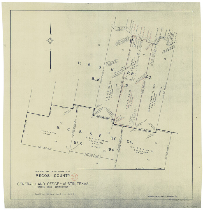
Print $20.00
- Digital $50.00
Pecos County Working Sketch 51
1948
Size 22.5 x 21.9 inches
Map/Doc 71523
Presidio County Sketch File 32

Print $8.00
- Digital $50.00
Presidio County Sketch File 32
1885
Size 11.2 x 8.7 inches
Map/Doc 34472
Wm. H. Bush Estate Resurveyed by W. D. Twichell May 1905

Print $40.00
- Digital $50.00
Wm. H. Bush Estate Resurveyed by W. D. Twichell May 1905
1905
Size 37.1 x 57.7 inches
Map/Doc 89788
Flight Mission No. DQO-3K, Frame 86, Galveston County

Print $20.00
- Digital $50.00
Flight Mission No. DQO-3K, Frame 86, Galveston County
1952
Size 18.9 x 22.4 inches
Map/Doc 85091
Kimble County Rolled Sketch 36

Print $20.00
- Digital $50.00
Kimble County Rolled Sketch 36
Size 27.5 x 22.4 inches
Map/Doc 6526
Sutton County Sketch File 3

Print $8.00
- Digital $50.00
Sutton County Sketch File 3
Size 12.9 x 8.5 inches
Map/Doc 37353
Collingsworth County

Print $20.00
- Digital $50.00
Collingsworth County
1880
Size 24.9 x 20.0 inches
Map/Doc 3420
Flight Mission No. BRA-6M, Frame 98, Jefferson County

Print $20.00
- Digital $50.00
Flight Mission No. BRA-6M, Frame 98, Jefferson County
1953
Size 18.5 x 22.2 inches
Map/Doc 85441
[R. M. Thompson Block A, Jones County School Land, and vicinity]
![91202, [R. M. Thompson Block A, Jones County School Land, and vicinity], Twichell Survey Records](https://historictexasmaps.com/wmedia_w700/maps/91202-1.tif.jpg)
Print $20.00
- Digital $50.00
[R. M. Thompson Block A, Jones County School Land, and vicinity]
Size 15.8 x 30.0 inches
Map/Doc 91202
