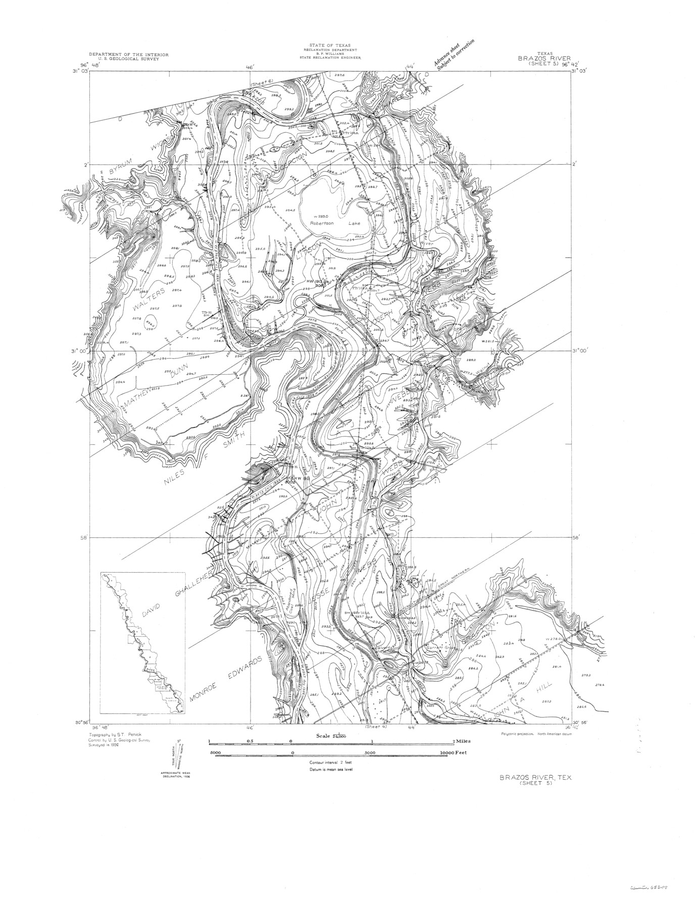
Brazos River, Brazos River Sheet 5
-
Map/Doc
65298
-
Collection
General Map Collection
-
Object Dates
1926 (Creation Date)
-
People and Organizations
Texas State Reclamation Department (Publisher)
S.T. Penick (Surveyor/Engineer)
-
Counties
Robertson Milam
-
Subjects
River Surveys Topographic
-
Height x Width
29.4 x 22.5 inches
74.7 x 57.2 cm
-
Comments
Brazos River Sheet 5 located north of the Brazos River Sheet 4 and south of the Brazos River Sheet 6.
Part of: General Map Collection
Lubbock County Boundary File 3

Print $2.00
- Digital $50.00
Lubbock County Boundary File 3
Size 11.3 x 8.8 inches
Map/Doc 56490
Wood County Working Sketch 20

Print $40.00
- Digital $50.00
Wood County Working Sketch 20
1985
Size 42.6 x 48.6 inches
Map/Doc 62020
Pecos County Sketch File 114

Print $18.00
- Digital $50.00
Pecos County Sketch File 114
1912
Size 13.3 x 8.9 inches
Map/Doc 34074
Cooke County Working Sketch 9

Print $20.00
- Digital $50.00
Cooke County Working Sketch 9
1940
Size 40.6 x 27.9 inches
Map/Doc 68246
Republic of Texas and boundaries as claimed by Texas from Decr. 19th, 1836 to Novr. 26th, 1850

Print $20.00
- Digital $50.00
Republic of Texas and boundaries as claimed by Texas from Decr. 19th, 1836 to Novr. 26th, 1850
1897
Size 20.7 x 19.3 inches
Map/Doc 93411
Karte von Texas entworfen nach den Vermessungen welche in den Acten der General Land Office der Republic liegen bis zum Jahr 1839

Print $20.00
- Digital $50.00
Karte von Texas entworfen nach den Vermessungen welche in den Acten der General Land Office der Republic liegen bis zum Jahr 1839
1845
Size 18.6 x 14.1 inches
Map/Doc 96629
Maps of Gulf Intracoastal Waterway, Texas - Sabine River to the Rio Grande and connecting waterways including ship channels

Print $20.00
- Digital $50.00
Maps of Gulf Intracoastal Waterway, Texas - Sabine River to the Rio Grande and connecting waterways including ship channels
1966
Size 14.5 x 22.3 inches
Map/Doc 61944
Flight Mission No. DCL-6C, Frame 16, Kenedy County

Print $20.00
- Digital $50.00
Flight Mission No. DCL-6C, Frame 16, Kenedy County
1943
Size 18.7 x 22.3 inches
Map/Doc 85873
Flight Mission No. DCL-6C, Frame 65, Kenedy County

Print $20.00
- Digital $50.00
Flight Mission No. DCL-6C, Frame 65, Kenedy County
1943
Size 18.5 x 22.3 inches
Map/Doc 85907
Caddo Lake and Subdivision

Print $20.00
- Digital $50.00
Caddo Lake and Subdivision
1918
Size 35.0 x 29.8 inches
Map/Doc 93283
Blanco County

Print $40.00
- Digital $50.00
Blanco County
1916
Size 48.7 x 35.7 inches
Map/Doc 66715
Harris County Historic Topographic 19

Print $20.00
- Digital $50.00
Harris County Historic Topographic 19
1915
Size 29.3 x 22.6 inches
Map/Doc 65830
You may also like
Travis County Rolled Sketch 55

Print $40.00
- Digital $50.00
Travis County Rolled Sketch 55
Size 43.1 x 50.5 inches
Map/Doc 10020
Cass County Sketch File 21

Print $6.00
- Digital $50.00
Cass County Sketch File 21
1936
Size 14.1 x 8.7 inches
Map/Doc 17424

Aransas County Rolled Sketch 31

Print $20.00
- Digital $50.00
Aransas County Rolled Sketch 31
1986
Size 30.0 x 41.4 inches
Map/Doc 77498
San Saba County Boundary File 1

Print $4.00
- Digital $50.00
San Saba County Boundary File 1
Size 14.2 x 8.7 inches
Map/Doc 58575
Andrews County Boundary File 1

Print $133.00
- Digital $50.00
Andrews County Boundary File 1
Size 14.6 x 9.0 inches
Map/Doc 49664
San Jacinto County Working Sketch 39

Print $20.00
- Digital $50.00
San Jacinto County Working Sketch 39
1971
Size 41.3 x 44.2 inches
Map/Doc 63752
Wichita County Sketch File 8

Print $4.00
- Digital $50.00
Wichita County Sketch File 8
1860
Size 11.7 x 8.2 inches
Map/Doc 40048
Bandera County Working Sketch 20

Print $20.00
- Digital $50.00
Bandera County Working Sketch 20
1947
Size 25.4 x 19.8 inches
Map/Doc 67616
Erath County Sketch File 34

Print $12.00
- Digital $50.00
Erath County Sketch File 34
1989
Size 14.3 x 8.9 inches
Map/Doc 22320
[Missouri, Kansas & Texas Line Map through Bastrop County]
![64028, [Missouri, Kansas & Texas Line Map through Bastrop County], General Map Collection](https://historictexasmaps.com/wmedia_w700/maps/64028.tif.jpg)
Print $40.00
- Digital $50.00
[Missouri, Kansas & Texas Line Map through Bastrop County]
1916
Size 26.2 x 121.8 inches
Map/Doc 64028
The Republic County of Jackson. 1841

Print $20.00
The Republic County of Jackson. 1841
2020
Size 15.6 x 21.8 inches
Map/Doc 96187