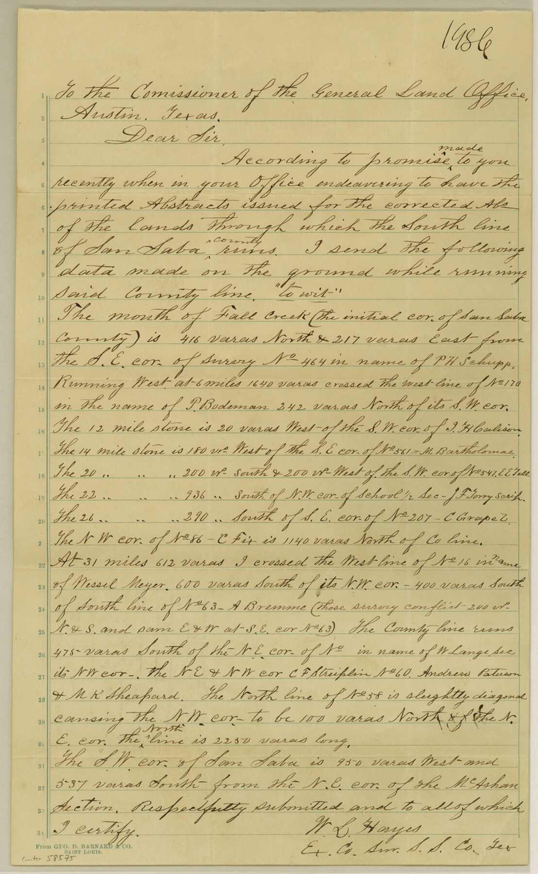
San Saba County Boundary File 1
Corrected Field Notes of South Boundary line of San Saba Co.
-
Map/Doc
58575
-
Collection
General Map Collection
-
Counties
San Saba
-
Subjects
County Boundaries
-
Height x Width
14.2 x 8.7 inches
36.1 x 22.1 cm
Part of: General Map Collection
No. IX - Outline map of the vicinity of Corpus Christi

Print $20.00
- Digital $50.00
No. IX - Outline map of the vicinity of Corpus Christi
Size 24.9 x 18.2 inches
Map/Doc 72966
Brazos County Working Sketch 7

Print $20.00
- Digital $50.00
Brazos County Working Sketch 7
1981
Size 12.1 x 33.1 inches
Map/Doc 67482
Hockley County Sketch File 15

Print $6.00
- Digital $50.00
Hockley County Sketch File 15
1912
Size 11.4 x 8.9 inches
Map/Doc 26550
Flight Mission No. DIX-8P, Frame 68, Aransas County

Print $20.00
- Digital $50.00
Flight Mission No. DIX-8P, Frame 68, Aransas County
1956
Size 18.7 x 22.5 inches
Map/Doc 83899
Terrell County Sketch File 15

Print $20.00
- Digital $50.00
Terrell County Sketch File 15
1890
Size 16.0 x 21.6 inches
Map/Doc 12421
Map showing the line of the True Southern Pacific Railway and the short link necessary for its completion

Print $20.00
- Digital $50.00
Map showing the line of the True Southern Pacific Railway and the short link necessary for its completion
1881
Size 10.5 x 26.7 inches
Map/Doc 93789
Shelby County Rolled Sketch 10

Print $20.00
- Digital $50.00
Shelby County Rolled Sketch 10
Size 16.2 x 27.3 inches
Map/Doc 7778
Eastland County Working Sketch 46

Print $20.00
- Digital $50.00
Eastland County Working Sketch 46
1980
Size 33.4 x 36.6 inches
Map/Doc 68827
Hansford County Sketch File 7

Print $4.00
- Digital $50.00
Hansford County Sketch File 7
1927
Size 12.2 x 8.8 inches
Map/Doc 24958
Map of Nacogdoches County

Print $20.00
- Digital $50.00
Map of Nacogdoches County
1880
Size 23.9 x 20.9 inches
Map/Doc 3908
[Surveys in Austin's Colony south of the San Antonio Road and west of the Colorado River]
![50, [Surveys in Austin's Colony south of the San Antonio Road and west of the Colorado River], General Map Collection](https://historictexasmaps.com/wmedia_w700/maps/50.tif.jpg)
Print $20.00
- Digital $50.00
[Surveys in Austin's Colony south of the San Antonio Road and west of the Colorado River]
1840
Size 16.8 x 22.2 inches
Map/Doc 50
El Paso County Rolled Sketch 2A

Print $20.00
- Digital $50.00
El Paso County Rolled Sketch 2A
1889
Size 24.1 x 32.8 inches
Map/Doc 5821
You may also like
Coryell County Working Sketch 7

Print $20.00
- Digital $50.00
Coryell County Working Sketch 7
1944
Size 31.6 x 21.1 inches
Map/Doc 68214
General Highway Map, Freestone County, Texas

Print $20.00
General Highway Map, Freestone County, Texas
1961
Size 18.1 x 24.8 inches
Map/Doc 79472
[F. W. & D. C. Ry. Co. Alignment and Right of Way Map, Clay County]
![64722, [F. W. & D. C. Ry. Co. Alignment and Right of Way Map, Clay County], General Map Collection](https://historictexasmaps.com/wmedia_w700/maps/64722-1.tif.jpg)
Print $20.00
- Digital $50.00
[F. W. & D. C. Ry. Co. Alignment and Right of Way Map, Clay County]
1927
Size 18.7 x 11.7 inches
Map/Doc 64722
Map of Parts of Dawson and Borden Counties

Print $20.00
- Digital $50.00
Map of Parts of Dawson and Borden Counties
Size 22.7 x 17.6 inches
Map/Doc 92034
Garza County Working Sketch 1

Print $20.00
- Digital $50.00
Garza County Working Sketch 1
1902
Size 39.3 x 25.6 inches
Map/Doc 63148
Crockett County Working Sketch 22

Print $20.00
- Digital $50.00
Crockett County Working Sketch 22
1920
Size 25.6 x 19.5 inches
Map/Doc 68355
Brazoria County Sketch File 43

Print $18.00
- Digital $50.00
Brazoria County Sketch File 43
1949
Size 14.5 x 9.0 inches
Map/Doc 15059
Pecos County Working Sketch 46

Print $20.00
- Digital $50.00
Pecos County Working Sketch 46
1947
Size 27.8 x 18.0 inches
Map/Doc 71518
[Map showing T&P Lands in El Paso County]
![88932, [Map showing T&P Lands in El Paso County], Library of Congress](https://historictexasmaps.com/wmedia_w700/maps/88932.tif.jpg)
Print $20.00
[Map showing T&P Lands in El Paso County]
Size 22.2 x 17.1 inches
Map/Doc 88932
Randall County Working Sketch Graphic Index

Print $20.00
- Digital $50.00
Randall County Working Sketch Graphic Index
1958
Size 41.2 x 33.2 inches
Map/Doc 76676

Flight Mission No. DCL-4C, Frame 70, Kenedy County

Print $20.00
- Digital $50.00
Flight Mission No. DCL-4C, Frame 70, Kenedy County
1943
Size 18.7 x 22.4 inches
Map/Doc 85815