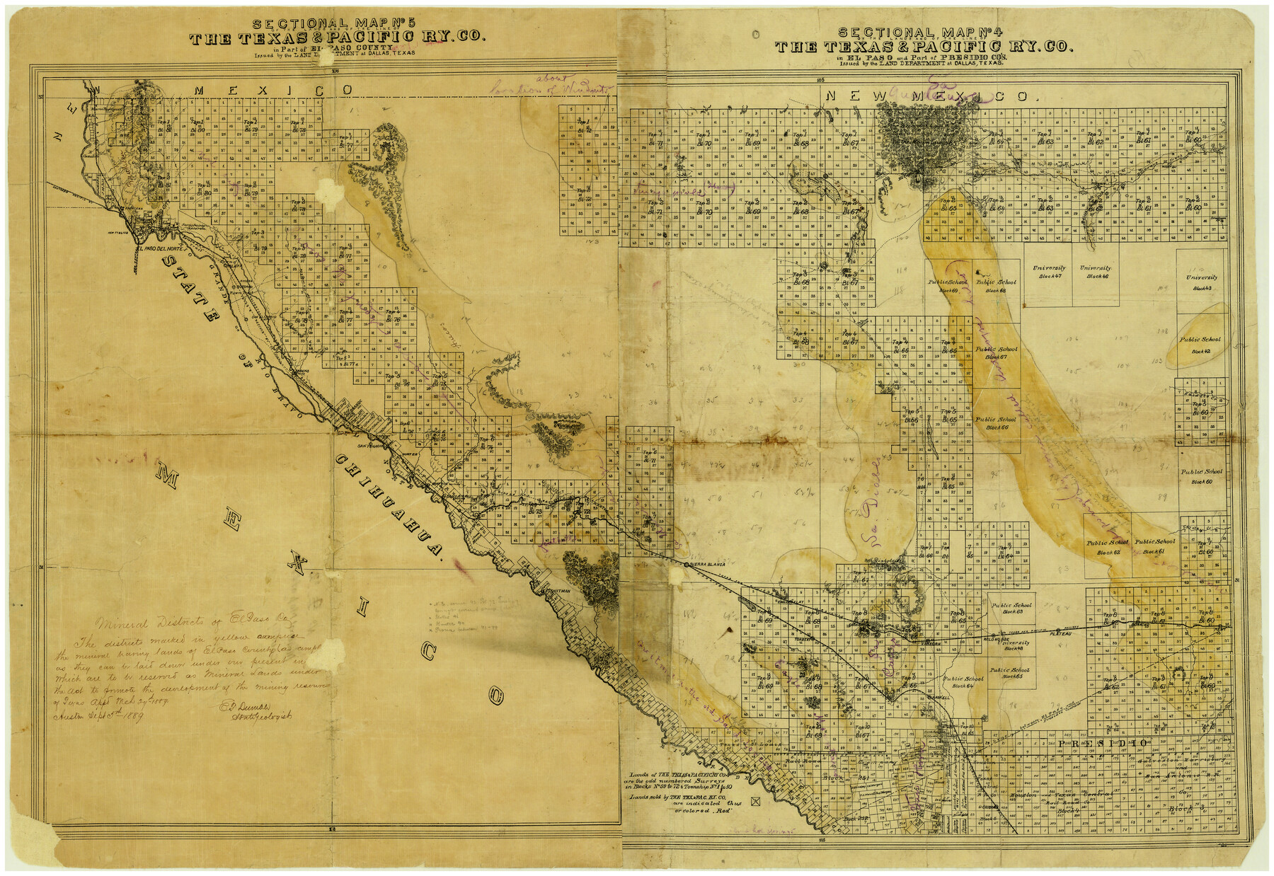
El Paso County Rolled Sketch 2A
Sectional Map Nos. 4 & 5, the Texas & Pacific Ry. Co. in El Paso and part of Presidio [and Hudspeth] Cos. issued by the Land Department at Dallas, Texas
-
Map/Doc
5821
-
Collection
General Map Collection
-
Object Dates
9/5/1889 (Creation Date)
-
People and Organizations
E.T. Dumble (Author)
-
Counties
El Paso Hudspeth Presidio
-
Subjects
Surveying Rolled Sketch
-
Height x Width
24.1 x 32.8 inches
61.2 x 83.3 cm
-
Medium
paper, etching/engraving/lithograph
-
Comments
Maps used to mark the mineral districts of El Paso County, by State Geologist, E.T. Dumble.
Part of: General Map Collection
Dimmit County Working Sketch 17

Print $20.00
- Digital $50.00
Dimmit County Working Sketch 17
1943
Size 27.4 x 24.7 inches
Map/Doc 68678
Jasper County Sketch File 1a

Print $8.00
- Digital $50.00
Jasper County Sketch File 1a
1859
Size 12.1 x 7.7 inches
Map/Doc 27765
Zavalla County

Print $20.00
- Digital $50.00
Zavalla County
1879
Size 21.2 x 25.4 inches
Map/Doc 4183
Tyler County Sketch File 16

Print $6.00
- Digital $50.00
Tyler County Sketch File 16
1860
Size 9.4 x 11.8 inches
Map/Doc 38661
[Jack District]
![1992, [Jack District], General Map Collection](https://historictexasmaps.com/wmedia_w700/maps/1992.tif.jpg)
Print $40.00
- Digital $50.00
[Jack District]
1880
Size 52.7 x 43.4 inches
Map/Doc 1992
Wilson County Sketch File 3

Print $6.00
- Digital $50.00
Wilson County Sketch File 3
1848
Size 13.3 x 8.6 inches
Map/Doc 40399
Hidalgo County Sketch File 8

Print $4.00
- Digital $50.00
Hidalgo County Sketch File 8
1890
Size 14.1 x 8.6 inches
Map/Doc 26407
La Salle County Rolled Sketch 22

Print $20.00
- Digital $50.00
La Salle County Rolled Sketch 22
1955
Size 31.0 x 30.3 inches
Map/Doc 6585
[Map of Nacogdoches County]
![10784, [Map of Nacogdoches County], General Map Collection](https://historictexasmaps.com/wmedia_w700/maps/10784-1.tif.jpg)
Print $40.00
- Digital $50.00
[Map of Nacogdoches County]
1840
Size 79.3 x 69.8 inches
Map/Doc 10784
San Saba County Sketch File 16

Print $20.00
- Digital $50.00
San Saba County Sketch File 16
1902
Size 16.9 x 18.8 inches
Map/Doc 12294
Maverick County Rolled Sketch 13

Print $20.00
- Digital $50.00
Maverick County Rolled Sketch 13
1848
Size 34.4 x 26.5 inches
Map/Doc 6706
Flight Mission No. BRA-8M, Frame 140, Jefferson County

Print $20.00
- Digital $50.00
Flight Mission No. BRA-8M, Frame 140, Jefferson County
1953
Size 18.6 x 22.2 inches
Map/Doc 85632
You may also like
Maps of Gulf Intracoastal Waterway, Texas - Sabine River to the Rio Grande and connecting waterways including ship channels

Print $20.00
- Digital $50.00
Maps of Gulf Intracoastal Waterway, Texas - Sabine River to the Rio Grande and connecting waterways including ship channels
1966
Size 14.5 x 20.8 inches
Map/Doc 61968
Gregg County Sketch File 13

Print $32.00
- Digital $50.00
Gregg County Sketch File 13
1934
Size 13.9 x 8.7 inches
Map/Doc 24597
Houston County Working Sketch 17

Print $40.00
- Digital $50.00
Houston County Working Sketch 17
1968
Size 43.4 x 50.3 inches
Map/Doc 66247
Flight Mission No. CRK-8P, Frame 98, Refugio County

Print $20.00
- Digital $50.00
Flight Mission No. CRK-8P, Frame 98, Refugio County
1956
Size 18.2 x 22.0 inches
Map/Doc 86959
Van Zandt County Sketch File 16

Print $4.00
- Digital $50.00
Van Zandt County Sketch File 16
1858
Size 6.8 x 8.0 inches
Map/Doc 39410
Kleberg County Rolled Sketch 10-36

Print $20.00
- Digital $50.00
Kleberg County Rolled Sketch 10-36
1952
Size 35.3 x 30.7 inches
Map/Doc 9382
Webb County Rolled Sketch 57

Print $20.00
- Digital $50.00
Webb County Rolled Sketch 57
Size 23.5 x 32.2 inches
Map/Doc 8209
Map of Starr County

Print $20.00
- Digital $50.00
Map of Starr County
1880
Size 46.8 x 27.0 inches
Map/Doc 4044
Callahan County Sketch File 10b

Print $6.00
- Digital $50.00
Callahan County Sketch File 10b
Size 12.1 x 10.8 inches
Map/Doc 35883
Revised Sectional Map No. 6 showing land surveys in parts of Presidio and Brewster Counties, Texas

Print $20.00
- Digital $50.00
Revised Sectional Map No. 6 showing land surveys in parts of Presidio and Brewster Counties, Texas
Size 24.2 x 23.0 inches
Map/Doc 4475
Flight Mission No. CGI-3N, Frame 180, Cameron County

Print $20.00
- Digital $50.00
Flight Mission No. CGI-3N, Frame 180, Cameron County
1954
Size 18.6 x 22.2 inches
Map/Doc 84644
University Lands Blocks 21 to 26, Pecos County, Texas

Print $40.00
- Digital $50.00
University Lands Blocks 21 to 26, Pecos County, Texas
1939
Size 48.4 x 39.9 inches
Map/Doc 2450