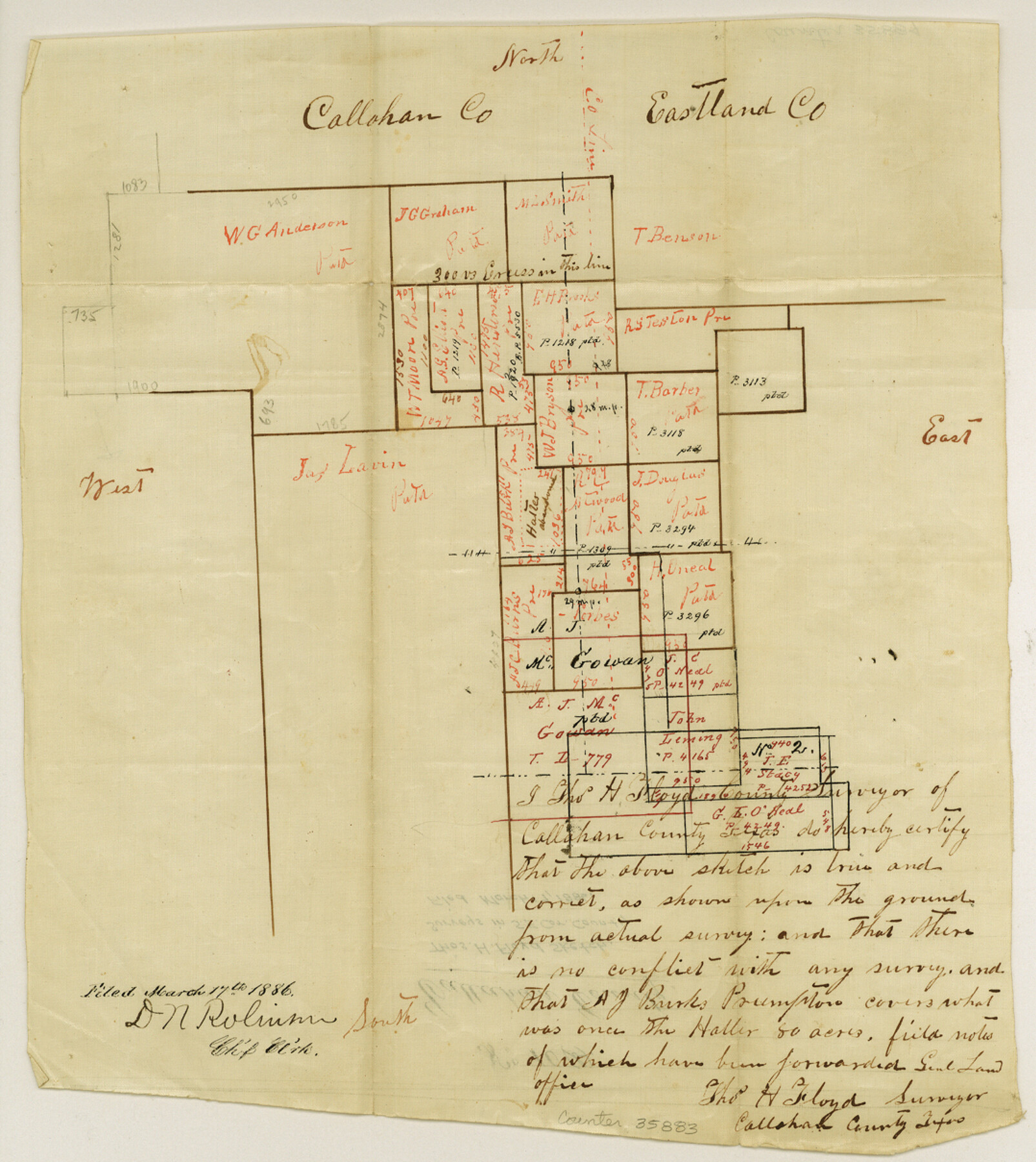
Callahan County Sketch File 10b
[Sketch of surveys near the intersection of Callahan, Eastland, and Brown Counties]
-
Map/Doc
35883
-
Collection
General Map Collection
-
Object Dates
1886/3/17 (File Date)
-
People and Organizations
Thos. H. Floyd (Surveyor/Engineer)
-
Counties
Brown Callahan Eastland
-
Subjects
Surveying Sketch File
-
Height x Width
12.1 x 10.8 inches
30.7 x 27.4 cm
-
Medium
paper, manuscript
Part of: General Map Collection
Wilbarger Co.

Print $40.00
- Digital $50.00
Wilbarger Co.
1889
Size 48.8 x 38.4 inches
Map/Doc 63125
Marion County Working Sketch 13

Print $20.00
- Digital $50.00
Marion County Working Sketch 13
1953
Size 33.2 x 36.3 inches
Map/Doc 70789
[The S.K. Ry. of Texas, State Line to Pecos, Reeves Co., Texas]
![64160, [The S.K. Ry. of Texas, State Line to Pecos, Reeves Co., Texas], General Map Collection](https://historictexasmaps.com/wmedia_w700/maps/64160.tif.jpg)
Print $40.00
- Digital $50.00
[The S.K. Ry. of Texas, State Line to Pecos, Reeves Co., Texas]
1910
Size 19.5 x 119.7 inches
Map/Doc 64160
Bee County Working Sketch 6

Print $20.00
- Digital $50.00
Bee County Working Sketch 6
1934
Size 33.8 x 24.1 inches
Map/Doc 67256
Station Map, the Missouri, Kansas and Texas Ry. Of Texas - Henrietta Division

Print $20.00
- Digital $50.00
Station Map, the Missouri, Kansas and Texas Ry. Of Texas - Henrietta Division
1918
Size 11.7 x 26.8 inches
Map/Doc 64764
Young County Sketch File 14

Print $20.00
- Digital $50.00
Young County Sketch File 14
1895
Size 10.9 x 27.3 inches
Map/Doc 12712
Harris County Historic Topographic 9

Print $20.00
- Digital $50.00
Harris County Historic Topographic 9
1916
Size 14.6 x 24.0 inches
Map/Doc 65819
Flight Mission No. CRC-4R, Frame 179, Chambers County

Print $20.00
- Digital $50.00
Flight Mission No. CRC-4R, Frame 179, Chambers County
1956
Size 18.6 x 22.3 inches
Map/Doc 84930
Copy of a chart of Aransas and Corpus Christi Bays by an inhabitant of St. Joseph's Island, the main features of which have been verified by the examinations of Capt. Crosman and other officers of the army

Print $20.00
- Digital $50.00
Copy of a chart of Aransas and Corpus Christi Bays by an inhabitant of St. Joseph's Island, the main features of which have been verified by the examinations of Capt. Crosman and other officers of the army
1845
Size 26.4 x 18.5 inches
Map/Doc 73013
Houston County Working Sketch Graphic Index

Print $40.00
- Digital $50.00
Houston County Working Sketch Graphic Index
1944
Size 48.1 x 42.7 inches
Map/Doc 76582
Liberty County Sketch File 57

Print $40.00
- Digital $50.00
Liberty County Sketch File 57
1928
Size 55.1 x 17.4 inches
Map/Doc 10523
Kinney County Sketch File 15

Print $20.00
- Digital $50.00
Kinney County Sketch File 15
1887
Size 13.0 x 19.0 inches
Map/Doc 11940
You may also like
Parker County Sketch File 41

Print $4.00
- Digital $50.00
Parker County Sketch File 41
1877
Size 8.9 x 10.6 inches
Map/Doc 33587
Hemphill County Working Sketch 8

Print $40.00
- Digital $50.00
Hemphill County Working Sketch 8
1965
Size 25.8 x 64.6 inches
Map/Doc 66103
A Pocket Guide to Austin, Texas - Area Map and Downtown Map

A Pocket Guide to Austin, Texas - Area Map and Downtown Map
Size 17.2 x 20.2 inches
Map/Doc 94386
Hamilton County Rolled Sketch 13

Print $20.00
- Digital $50.00
Hamilton County Rolled Sketch 13
1982
Size 34.0 x 28.0 inches
Map/Doc 6062
Guadalupe County Sketch File 15e

Print $6.00
- Digital $50.00
Guadalupe County Sketch File 15e
Size 9.9 x 8.1 inches
Map/Doc 24707
Crockett County Sketch File KL

Print $20.00
- Digital $50.00
Crockett County Sketch File KL
1925
Size 30.0 x 28.7 inches
Map/Doc 11243
Hale County Boundary File 5

Print $4.00
- Digital $50.00
Hale County Boundary File 5
Size 14.1 x 8.7 inches
Map/Doc 54071
Medina County Working Sketch 8

Print $20.00
- Digital $50.00
Medina County Working Sketch 8
1955
Size 23.4 x 18.4 inches
Map/Doc 70923
Dimmit County Sketch File 48

Print $20.00
- Digital $50.00
Dimmit County Sketch File 48
1909
Size 17.9 x 19.3 inches
Map/Doc 11357
McMullen County Sketch File 31

Print $20.00
- Digital $50.00
McMullen County Sketch File 31
Size 44.7 x 15.6 inches
Map/Doc 10541
The Republic County of Bexar. November 28, 1839

Print $20.00
The Republic County of Bexar. November 28, 1839
2020
Size 14.8 x 21.1 inches
Map/Doc 96097
Flight Mission No. DAG-24K, Frame 139, Matagorda County

Print $20.00
- Digital $50.00
Flight Mission No. DAG-24K, Frame 139, Matagorda County
1953
Size 18.5 x 22.3 inches
Map/Doc 86557