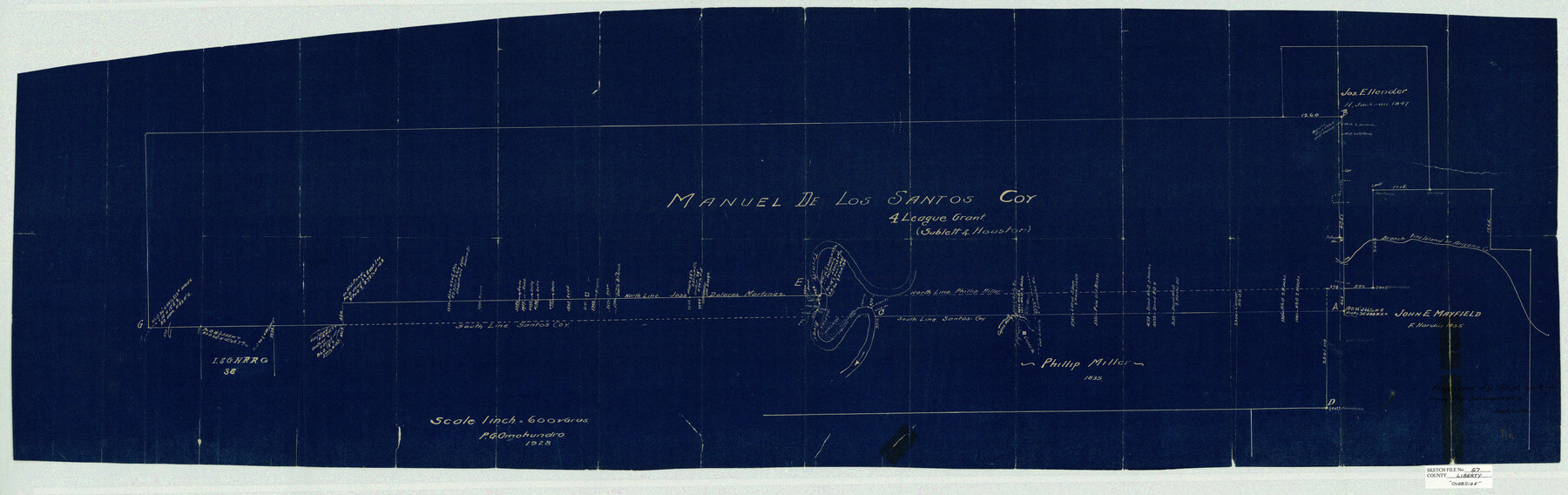
Liberty County Sketch File 57
[Sketch showing the Manuel de los Santos Coy 4 league survey on both sides of the Trinity River in the north part of the county]
-
Map/Doc
10523
-
Collection
General Map Collection
-
Object Dates
1928 (Creation Date)
3/4/1930 (File Date)
-
People and Organizations
P.G. Omohundro (Surveyor/Engineer)
-
Counties
Liberty
-
Subjects
Surveying Sketch File
-
Height x Width
55.1 x 17.4 inches
140.0 x 44.2 cm
-
Medium
blueprint/diazo
-
Scale
1" = 600 varas
-
Features
Pine Island Creek
Arizona Creek
Copas House
Copes Gully
New Liberty and Linnyston Road
Trinity River
Part of: General Map Collection
Williamson County Working Sketch 8

Print $20.00
- Digital $50.00
Williamson County Working Sketch 8
1950
Size 43.4 x 25.4 inches
Map/Doc 72568
Brewster County Rolled Sketch 80

Print $40.00
- Digital $50.00
Brewster County Rolled Sketch 80
1943
Size 51.6 x 42.7 inches
Map/Doc 8493
Cooke County Working Sketch 14

Print $40.00
- Digital $50.00
Cooke County Working Sketch 14
1944
Size 34.1 x 49.7 inches
Map/Doc 68251
[Corpus Christi Bay, Padre Island, Mustang Island, Laguna de la Madre, King and Kenedy's Pasture]
![73046, [Corpus Christi Bay, Padre Island, Mustang Island, Laguna de la Madre, King and Kenedy's Pasture], General Map Collection](https://historictexasmaps.com/wmedia_w700/maps/73046.tif.jpg)
Print $20.00
- Digital $50.00
[Corpus Christi Bay, Padre Island, Mustang Island, Laguna de la Madre, King and Kenedy's Pasture]
Size 26.4 x 18.2 inches
Map/Doc 73046
Nueces River, Corpus Christi Sheet No. 6

Print $6.00
- Digital $50.00
Nueces River, Corpus Christi Sheet No. 6
1938
Size 31.3 x 31.0 inches
Map/Doc 65095
Val Verde County Rolled Sketch 53

Print $20.00
- Digital $50.00
Val Verde County Rolled Sketch 53
1937
Size 32.0 x 25.0 inches
Map/Doc 8122
Van Zandt County

Print $20.00
- Digital $50.00
Van Zandt County
1921
Size 46.7 x 41.4 inches
Map/Doc 63104
Coleman County Working Sketch 6

Print $20.00
- Digital $50.00
Coleman County Working Sketch 6
1939
Size 19.1 x 21.8 inches
Map/Doc 68072
Atascosa County Working Sketch 20

Print $20.00
- Digital $50.00
Atascosa County Working Sketch 20
1953
Size 22.9 x 25.5 inches
Map/Doc 67216
Wharton County Rolled Sketch 5

Print $20.00
- Digital $50.00
Wharton County Rolled Sketch 5
1899
Size 19.3 x 24.6 inches
Map/Doc 8229
Flight Mission No. BRA-3M, Frame 121, Jefferson County

Print $20.00
- Digital $50.00
Flight Mission No. BRA-3M, Frame 121, Jefferson County
1953
Size 18.8 x 22.3 inches
Map/Doc 85395
Trinity River, Mountain Creek Sheet

Print $40.00
- Digital $50.00
Trinity River, Mountain Creek Sheet
1918
Size 51.3 x 34.7 inches
Map/Doc 65211
You may also like
Dominguez Empresario Colony. February 6, 1829

Print $20.00
Dominguez Empresario Colony. February 6, 1829
2020
Size 17.2 x 21.7 inches
Map/Doc 95992
Pecos County Rolled Sketch JAS-1

Print $40.00
- Digital $50.00
Pecos County Rolled Sketch JAS-1
1936
Size 41.8 x 63.8 inches
Map/Doc 76146
Webb County Sketch File 9c

Print $20.00
- Digital $50.00
Webb County Sketch File 9c
1930
Size 18.7 x 22.1 inches
Map/Doc 12621
Burnet County Sketch File 39

Print $40.00
- Digital $50.00
Burnet County Sketch File 39
Size 9.6 x 24.1 inches
Map/Doc 11028
Texas, San Antonio Bay, Panther Point

Print $40.00
- Digital $50.00
Texas, San Antonio Bay, Panther Point
1934
Size 33.2 x 48.3 inches
Map/Doc 69995
Hood County Working Sketch 28

Print $20.00
- Digital $50.00
Hood County Working Sketch 28
1995
Size 17.5 x 11.4 inches
Map/Doc 66222
Map of Mexico, Texas, Old and New California, and Yucatan

Print $20.00
Map of Mexico, Texas, Old and New California, and Yucatan
1847
Size 17.9 x 24.4 inches
Map/Doc 76191
Brazos County Working Sketch 8

Print $20.00
- Digital $50.00
Brazos County Working Sketch 8
1981
Size 18.0 x 13.8 inches
Map/Doc 67483
Hardin County Sketch File 17

Print $6.00
- Digital $50.00
Hardin County Sketch File 17
1854
Size 15.9 x 9.9 inches
Map/Doc 25130
Kimble County Sketch File 36

Print $20.00
- Digital $50.00
Kimble County Sketch File 36
1963
Size 22.2 x 25.0 inches
Map/Doc 11932
Henderson County Working Sketch 20

Print $20.00
- Digital $50.00
Henderson County Working Sketch 20
1947
Size 31.6 x 18.9 inches
Map/Doc 66153
J. R. Jameson Farm

Print $2.00
- Digital $50.00
J. R. Jameson Farm
Size 9.1 x 13.9 inches
Map/Doc 92327