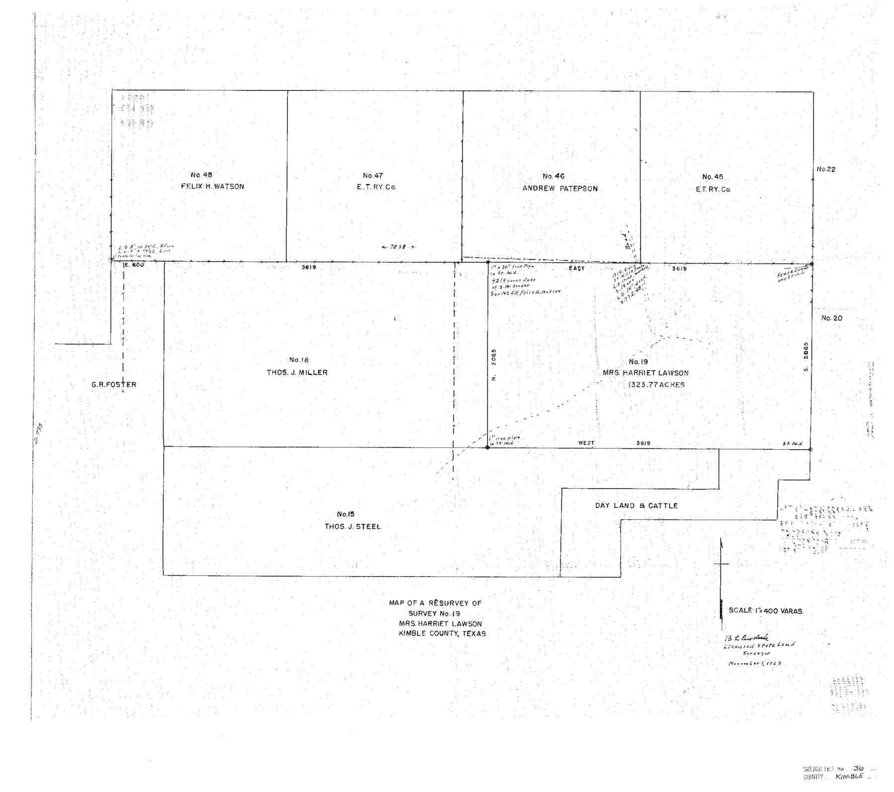
Kimble County Sketch File 36
Map of a Resurvey of Survey No. 19, Mrs. Harriet Lawson, Kimble County, Texas
-
Map/Doc
11932
-
Collection
General Map Collection
-
Object Dates
11/1/1963 (Creation Date)
12/5/1963 (File Date)
-
People and Organizations
B.L. Enderle (Surveyor/Engineer)
-
Counties
Kimble
-
Subjects
Surveying Sketch File
-
Height x Width
22.2 x 25.0 inches
56.4 x 63.5 cm
-
Medium
paper, print
-
Scale
1" = 400 varas
Part of: General Map Collection
Flight Mission No. BRA-9M, Frame 61, Jefferson County

Print $20.00
- Digital $50.00
Flight Mission No. BRA-9M, Frame 61, Jefferson County
1953
Size 18.7 x 22.4 inches
Map/Doc 85644
A Map of the British Empire in North America

Print $20.00
- Digital $50.00
A Map of the British Empire in North America
1774
Size 22.1 x 15.1 inches
Map/Doc 93733
Nueces County Rolled Sketch 63A

Print $20.00
- Digital $50.00
Nueces County Rolled Sketch 63A
1979
Size 25.0 x 36.7 inches
Map/Doc 6910
Cherokee County Sketch File 4

Print $7.00
- Digital $50.00
Cherokee County Sketch File 4
1850
Size 10.3 x 8.2 inches
Map/Doc 18117
Sabine County Working Sketch 2

Print $3.00
- Digital $50.00
Sabine County Working Sketch 2
1906
Size 12.5 x 10.8 inches
Map/Doc 63673
Matagorda County Rolled Sketch 18A

Print $20.00
- Digital $50.00
Matagorda County Rolled Sketch 18A
1838
Size 35.4 x 30.1 inches
Map/Doc 6686
Liberty County Working Sketch 21

Print $20.00
- Digital $50.00
Liberty County Working Sketch 21
1940
Size 20.1 x 15.0 inches
Map/Doc 70480
Brazoria County Rolled Sketch 31

Print $20.00
- Digital $50.00
Brazoria County Rolled Sketch 31
Size 25.6 x 45.9 inches
Map/Doc 5169
Harrison County Sketch File 9

Print $4.00
- Digital $50.00
Harrison County Sketch File 9
1862
Size 8.3 x 11.1 inches
Map/Doc 26048
Flight Mission No. BRE-3P, Frame 34, Nueces County

Print $20.00
- Digital $50.00
Flight Mission No. BRE-3P, Frame 34, Nueces County
1956
Size 18.5 x 22.3 inches
Map/Doc 86812
Orange County NRC Article 33.136 Sketch 5

Print $62.00
- Digital $50.00
Orange County NRC Article 33.136 Sketch 5
2014
Size 26.1 x 22.7 inches
Map/Doc 94946
Brown County Rolled Sketch 2

Print $20.00
- Digital $50.00
Brown County Rolled Sketch 2
1984
Size 42.4 x 25.2 inches
Map/Doc 5349
You may also like
Flight Mission No. CRE-1R, Frame 197, Jackson County

Print $20.00
- Digital $50.00
Flight Mission No. CRE-1R, Frame 197, Jackson County
1956
Size 18.5 x 22.4 inches
Map/Doc 85351
Map of Hunt County

Print $20.00
- Digital $50.00
Map of Hunt County
1851
Size 27.0 x 19.8 inches
Map/Doc 4569

Bailey County Working Sketch 6

Print $20.00
- Digital $50.00
Bailey County Working Sketch 6
1966
Size 37.0 x 34.5 inches
Map/Doc 67593
Sketch Showing Original Corners Affecting Block I and Adjacent Surveys from Actual Connections by W. D. Twichell

Print $20.00
- Digital $50.00
Sketch Showing Original Corners Affecting Block I and Adjacent Surveys from Actual Connections by W. D. Twichell
Size 23.6 x 24.5 inches
Map/Doc 90156
Baylor County Sketch File A2

Print $4.00
- Digital $50.00
Baylor County Sketch File A2
1899
Size 10.4 x 8.2 inches
Map/Doc 14075
Angelina County Sketch File 2

Print $2.00
- Digital $50.00
Angelina County Sketch File 2
Size 8.6 x 6.0 inches
Map/Doc 12921
Hill County Sketch File 14

Print $4.00
- Digital $50.00
Hill County Sketch File 14
Size 3.8 x 4.3 inches
Map/Doc 26480
Hardin County Rolled Sketch 13

Print $20.00
- Digital $50.00
Hardin County Rolled Sketch 13
1950
Size 29.8 x 27.4 inches
Map/Doc 9188

Throckmorton County Sketch File 13

Print $20.00
- Digital $50.00
Throckmorton County Sketch File 13
1994
Size 11.3 x 9.1 inches
Map/Doc 38120
Atascosa County Rolled Sketch 4

Print $20.00
- Digital $50.00
Atascosa County Rolled Sketch 4
Size 21.0 x 15.8 inches
Map/Doc 5087