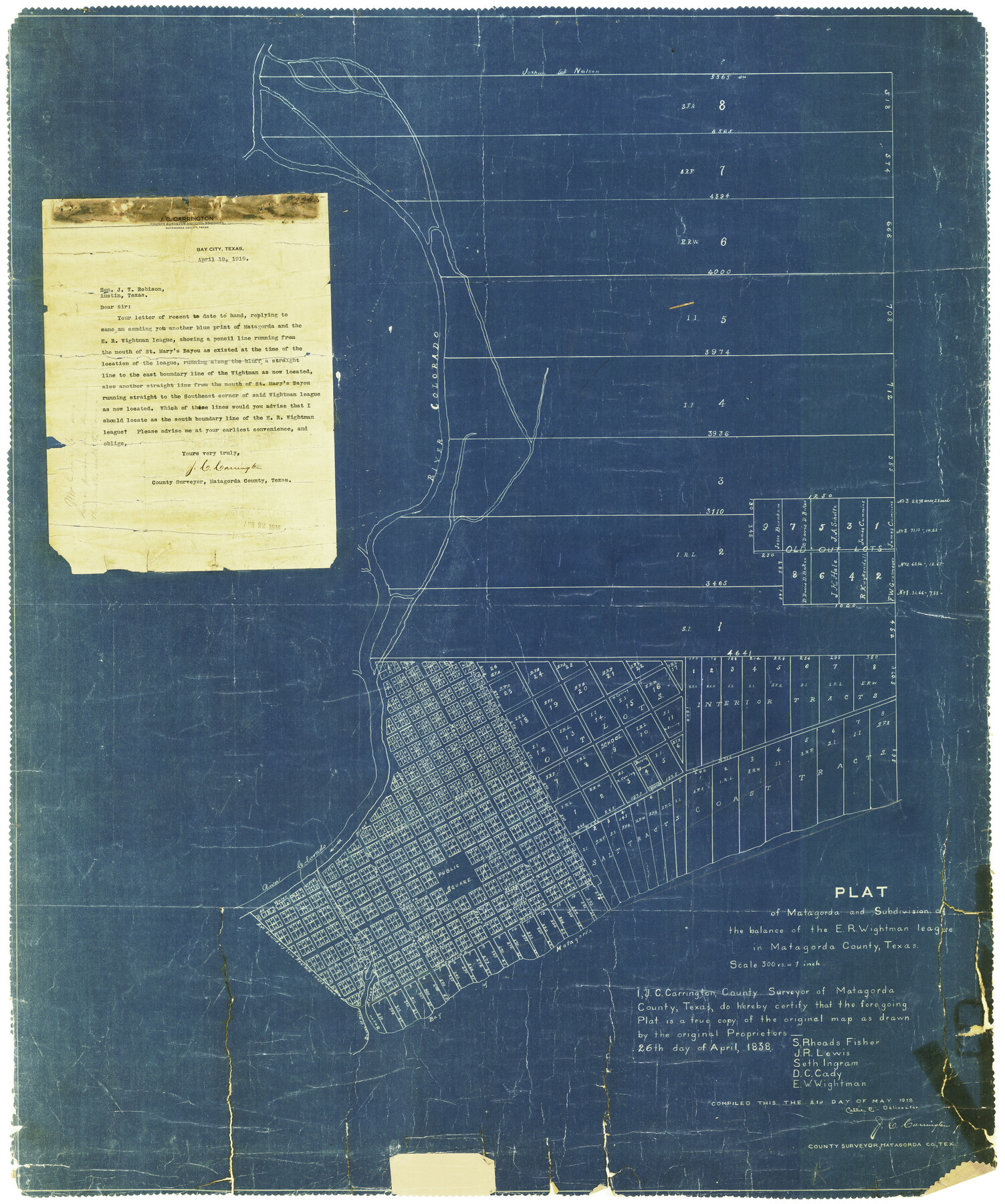
Matagorda County Rolled Sketch 18A
[Copy of] Plat of Matagorda and subdivision of the balance of the E.R. Wightman league in Matagorda County, Texas
-
Map/Doc
6686
-
Collection
General Map Collection
-
Object Dates
4/29/1838 (Creation Date)
4/29/1919 (File Date)
5/21/1918 (Copy/Tracing Date)
-
People and Organizations
J.C. Carrington (Surveyor/Engineer)
-
Counties
Matagorda
-
Subjects
Surveying Rolled Sketch
-
Height x Width
35.4 x 30.1 inches
89.9 x 76.5 cm
-
Medium
blueprint/diazo
-
Scale
1" = 300 varas
Part of: General Map Collection
Gulf of Mexico

Print $20.00
- Digital $50.00
Gulf of Mexico
1900
Size 18.3 x 28.1 inches
Map/Doc 72650

Red River County Working Sketch 36

Print $20.00
- Digital $50.00
Red River County Working Sketch 36
1964
Size 42.4 x 42.7 inches
Map/Doc 72019
Edwards County Working Sketch 1

Print $20.00
- Digital $50.00
Edwards County Working Sketch 1
Size 12.2 x 16.4 inches
Map/Doc 68877
Map of Eastland County, the portion on the waters of Colorado River, Travis - the balance, Milam Land District

Print $20.00
- Digital $50.00
Map of Eastland County, the portion on the waters of Colorado River, Travis - the balance, Milam Land District
1860
Size 23.8 x 21.5 inches
Map/Doc 3501
Flight Mission No. CRC-4R, Frame 109, Chambers County

Print $20.00
- Digital $50.00
Flight Mission No. CRC-4R, Frame 109, Chambers County
1956
Size 18.5 x 22.5 inches
Map/Doc 84906
Flight Mission No. DAG-17K, Frame 141, Matagorda County

Print $20.00
- Digital $50.00
Flight Mission No. DAG-17K, Frame 141, Matagorda County
1952
Size 16.3 x 16.4 inches
Map/Doc 86358
Henderson County

Print $20.00
- Digital $50.00
Henderson County
1856
Size 17.9 x 29.2 inches
Map/Doc 3664
Galveston County NRC Article 33.136 Sketch 26

Print $45.00
- Digital $50.00
Galveston County NRC Article 33.136 Sketch 26
2003
Size 32.6 x 24.3 inches
Map/Doc 81943
[Sketch for Mineral Application 24072, San Jacinto River]
![65596, [Sketch for Mineral Application 24072, San Jacinto River], General Map Collection](https://historictexasmaps.com/wmedia_w700/maps/65596.tif.jpg)
Print $20.00
- Digital $50.00
[Sketch for Mineral Application 24072, San Jacinto River]
1929
Size 24.5 x 18.5 inches
Map/Doc 65596
Kerr County State Real Property Sketch 1

Print $20.00
- Digital $50.00
Kerr County State Real Property Sketch 1
2007
Size 24.9 x 35.1 inches
Map/Doc 88669
Presidio County Rolled Sketch A-1

Print $20.00
- Digital $50.00
Presidio County Rolled Sketch A-1
1889
Size 26.8 x 32.0 inches
Map/Doc 9769
You may also like
Motley County

Print $20.00
- Digital $50.00
Motley County
1966
Size 44.8 x 35.8 inches
Map/Doc 95597
Flight Mission No. CUG-2P, Frame 59, Kleberg County

Print $20.00
- Digital $50.00
Flight Mission No. CUG-2P, Frame 59, Kleberg County
1956
Size 18.4 x 22.1 inches
Map/Doc 86196

Llano County Working Sketch 9

Print $20.00
- Digital $50.00
Llano County Working Sketch 9
1979
Size 33.4 x 24.0 inches
Map/Doc 70627
Flight Mission No. DIX-5P, Frame 114, Aransas County

Print $20.00
- Digital $50.00
Flight Mission No. DIX-5P, Frame 114, Aransas County
1956
Size 17.4 x 17.6 inches
Map/Doc 83793
McMullen County Working Sketch 19

Print $20.00
- Digital $50.00
McMullen County Working Sketch 19
1944
Size 26.1 x 29.2 inches
Map/Doc 70720
Taylor County Boundary File 1

Print $44.00
- Digital $50.00
Taylor County Boundary File 1
Size 8.4 x 8.2 inches
Map/Doc 59184
Map of Travis County

Print $40.00
- Digital $50.00
Map of Travis County
1895
Size 48.8 x 54.1 inches
Map/Doc 82083
Photostat of section of hydrographic surveys H-5399, H-4822, H-470

Print $20.00
- Digital $50.00
Photostat of section of hydrographic surveys H-5399, H-4822, H-470
1933
Size 25.9 x 18.3 inches
Map/Doc 61158
PSL Field Notes for Blocks 99, 100, 101, 103, 104, 105, 106, 107, 108, and 109 in Culberson County

PSL Field Notes for Blocks 99, 100, 101, 103, 104, 105, 106, 107, 108, and 109 in Culberson County
Map/Doc 81665
Runnels County Working Sketch 18

Print $20.00
- Digital $50.00
Runnels County Working Sketch 18
1950
Size 27.9 x 31.2 inches
Map/Doc 63614
Flight Mission No. DCL-6C, Frame 94, Kenedy County

Print $20.00
- Digital $50.00
Flight Mission No. DCL-6C, Frame 94, Kenedy County
1943
Size 18.6 x 22.3 inches
Map/Doc 85924