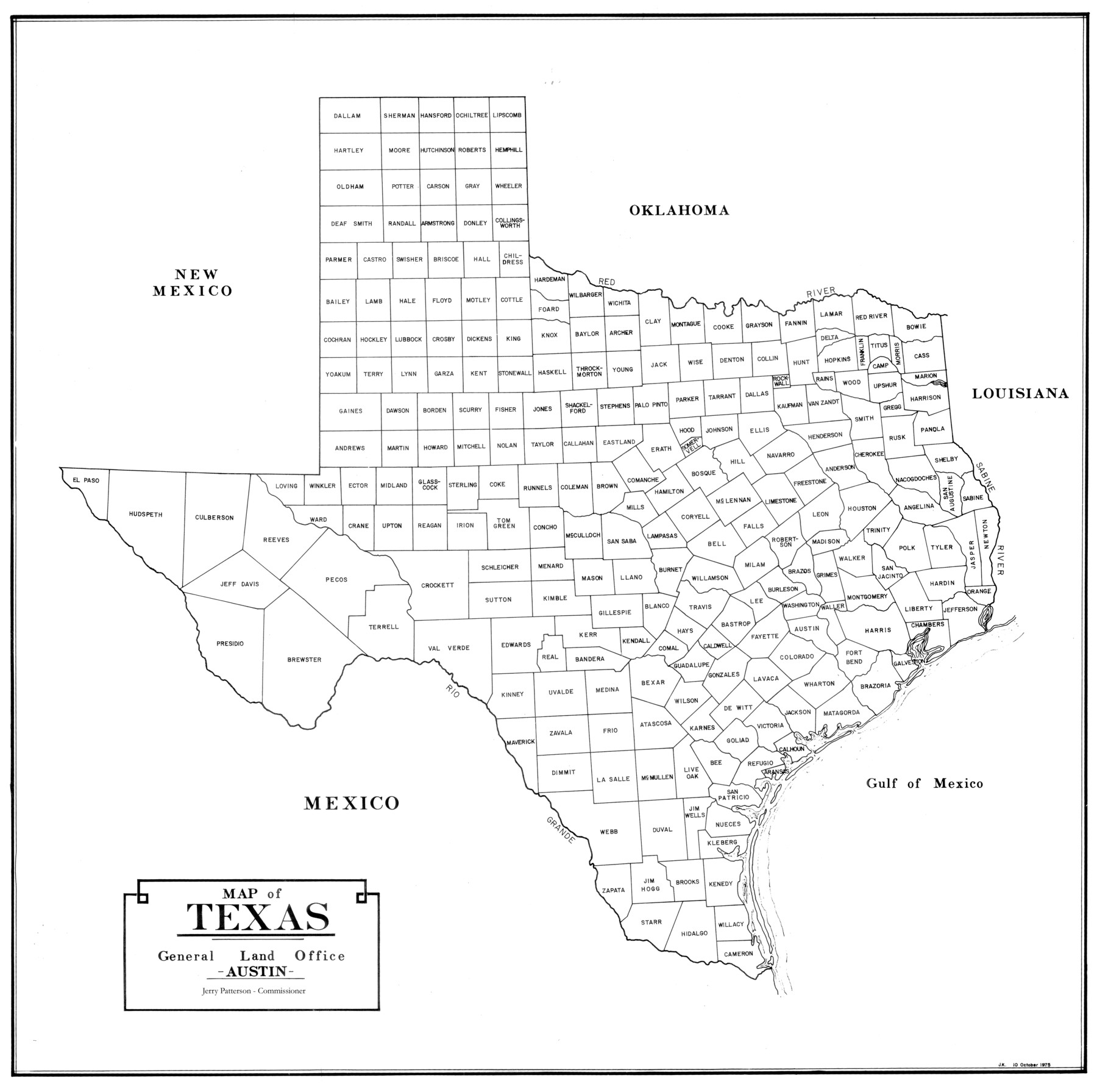
Map of Texas
-
Map/Doc
2161
-
Collection
General Map Collection
-
Object Dates
1975 (Creation Date)
-
People and Organizations
General Land Office (Publisher)
Jerry E. Patterson (GLO Commissioner)
-
Subjects
State of Texas
-
Height x Width
21.6 x 21.7 inches
54.9 x 55.1 cm
-
Medium
digital image
-
Comments
Basic map showing the present-day counties in Texas.
Part of: General Map Collection
Map of Gray County

Print $20.00
- Digital $50.00
Map of Gray County
1900
Size 43.4 x 40.5 inches
Map/Doc 95511
A Map of the Internal Provinces of New Spain

Print $20.00
- Digital $50.00
A Map of the Internal Provinces of New Spain
1810
Size 19.8 x 21.0 inches
Map/Doc 95156
Zavala County Sketch File 19

Print $6.00
- Digital $50.00
Zavala County Sketch File 19
1909
Size 5.6 x 8.8 inches
Map/Doc 41371
Reeves County Working Sketch 7

Print $20.00
- Digital $50.00
Reeves County Working Sketch 7
1946
Size 36.7 x 43.9 inches
Map/Doc 63450
St. Marks to Galveston - Sheet II

Print $20.00
- Digital $50.00
St. Marks to Galveston - Sheet II
1846
Size 26.5 x 40.5 inches
Map/Doc 97397
[Surveys in the Milam District along the Leon River]
![272, [Surveys in the Milam District along the Leon River], General Map Collection](https://historictexasmaps.com/wmedia_w700/maps/272.tif.jpg)
Print $20.00
- Digital $50.00
[Surveys in the Milam District along the Leon River]
1845
Size 12.0 x 15.4 inches
Map/Doc 272
Limestone County Working Sketch 16

Print $40.00
- Digital $50.00
Limestone County Working Sketch 16
1951
Size 55.7 x 27.8 inches
Map/Doc 70566
Map showing lands acquired for reservoir purposes in connection with Lake Worth and the boundary of territory annexed to the City of Fort Worth, Texas

Print $40.00
- Digital $50.00
Map showing lands acquired for reservoir purposes in connection with Lake Worth and the boundary of territory annexed to the City of Fort Worth, Texas
Size 46.4 x 58.9 inches
Map/Doc 62209
Bandera County Sketch File 4

Print $4.00
- Digital $50.00
Bandera County Sketch File 4
Size 9.3 x 8.3 inches
Map/Doc 14001


Map of Chambers County

Print $20.00
- Digital $50.00
Map of Chambers County
1874
Size 20.4 x 24.4 inches
Map/Doc 3380
You may also like
Flight Mission No. CGI-4N, Frame 161, Cameron County

Print $20.00
- Digital $50.00
Flight Mission No. CGI-4N, Frame 161, Cameron County
1955
Size 18.7 x 22.4 inches
Map/Doc 84669
The Magic Valley of the Lower Rio Grande

The Magic Valley of the Lower Rio Grande
1926
Map/Doc 96733
Estes Quadrangle

Print $20.00
- Digital $50.00
Estes Quadrangle
1971
Size 27.8 x 23.6 inches
Map/Doc 73442
Webb County Rolled Sketch 72

Print $20.00
- Digital $50.00
Webb County Rolled Sketch 72
1976
Size 25.5 x 17.5 inches
Map/Doc 8220
Sutton County Sketch File 6a

Print $6.00
- Digital $50.00
Sutton County Sketch File 6a
1898
Size 7.5 x 6.4 inches
Map/Doc 37362
Reeves County Sketch File 20

Print $8.00
- Digital $50.00
Reeves County Sketch File 20
1943
Size 9.9 x 8.5 inches
Map/Doc 35216
Presidio County Rolled Sketch D2

Print $20.00
- Digital $50.00
Presidio County Rolled Sketch D2
1908
Size 14.3 x 16.9 inches
Map/Doc 7410
Flight Mission No. BRA-16M, Frame 129, Jefferson County

Print $20.00
- Digital $50.00
Flight Mission No. BRA-16M, Frame 129, Jefferson County
1953
Size 18.4 x 22.7 inches
Map/Doc 85739
Pecos County Sketch File 102

Print $4.00
- Digital $50.00
Pecos County Sketch File 102
Size 9.9 x 4.4 inches
Map/Doc 34014
Sherman County Sketch File 8

Print $61.00
- Digital $50.00
Sherman County Sketch File 8
1993
Size 11.4 x 8.9 inches
Map/Doc 36726
The Mexican Department of Nacogdoches. Created, January 31, 1831

Print $20.00
The Mexican Department of Nacogdoches. Created, January 31, 1831
2020
Size 18.4 x 21.7 inches
Map/Doc 95972
La Salle County Sketch File 1

Print $5.00
- Digital $50.00
La Salle County Sketch File 1
1850
Size 14.2 x 9.2 inches
Map/Doc 29443