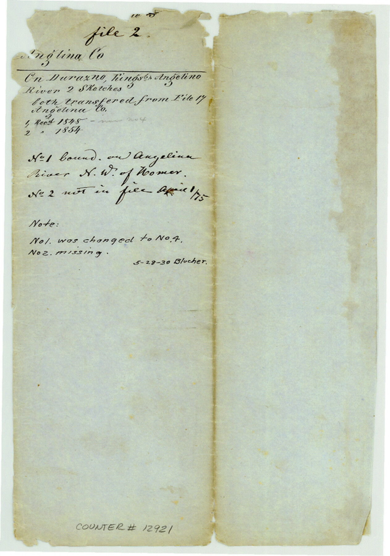
Angelina County Sketch File 2
[Jacket only]
-
Map/Doc
12921
-
Collection
General Map Collection
-
Counties
Angelina
-
Subjects
Surveying Sketch File
-
Height x Width
8.6 x 6.0 inches
21.8 x 15.2 cm
-
Medium
paper, manuscript
-
Comments
Part 1 of this file now filed as Angelina County Sketch File 4 (12926); Part 2 has been missing since May 28,1930.
-
Features
Durazno River
Angelina River
King's Creek
Related maps
Angelina County Sketch File 4

Print $4.00
- Digital $50.00
Angelina County Sketch File 4
1854
Size 8.3 x 9.0 inches
Map/Doc 12926
Part of: General Map Collection
Jefferson County Working Sketch 40

Print $40.00
- Digital $50.00
Jefferson County Working Sketch 40
1985
Size 58.9 x 42.2 inches
Map/Doc 66584
Bexar County Sketch File 11

Print $2.00
- Digital $50.00
Bexar County Sketch File 11
Size 8.3 x 9.5 inches
Map/Doc 14481
Map of Texas and Pacific Ry. Company's Surveys in the 80 Mile Reserve

Print $40.00
- Digital $50.00
Map of Texas and Pacific Ry. Company's Surveys in the 80 Mile Reserve
1885
Size 41.5 x 91.8 inches
Map/Doc 60313
Baylor County Working Sketch Graphic Index

Print $20.00
- Digital $50.00
Baylor County Working Sketch Graphic Index
1961
Size 41.1 x 33.6 inches
Map/Doc 76463
Milam County Working Sketch 8

Print $20.00
- Digital $50.00
Milam County Working Sketch 8
1970
Size 27.1 x 30.7 inches
Map/Doc 71023
Briscoe County Sketch File P

Print $40.00
- Digital $50.00
Briscoe County Sketch File P
Size 23.1 x 34.0 inches
Map/Doc 11014
Harris County Historic Topographic 18 1/2

Print $20.00
- Digital $50.00
Harris County Historic Topographic 18 1/2
1916
Size 29.3 x 13.7 inches
Map/Doc 65829
Schleicher County Working Sketch 14

Print $20.00
- Digital $50.00
Schleicher County Working Sketch 14
1928
Size 32.6 x 22.4 inches
Map/Doc 63816
Flight Mission No. BRE-2P, Frame 97, Nueces County

Print $20.00
- Digital $50.00
Flight Mission No. BRE-2P, Frame 97, Nueces County
1956
Size 18.5 x 22.3 inches
Map/Doc 86782
Starr County Working Sketch 28

Print $20.00
- Digital $50.00
Starr County Working Sketch 28
2004
Size 28.0 x 39.6 inches
Map/Doc 83010

Refugio County Rolled Sketch 5

Print $20.00
- Digital $50.00
Refugio County Rolled Sketch 5
1941
Size 45.0 x 42.5 inches
Map/Doc 9859
You may also like
Uvalde County Rolled Sketch 16

Print $20.00
- Digital $50.00
Uvalde County Rolled Sketch 16
Size 36.6 x 25.1 inches
Map/Doc 8100
Flight Mission No. BRA-16M, Frame 111, Jefferson County

Print $20.00
- Digital $50.00
Flight Mission No. BRA-16M, Frame 111, Jefferson County
1953
Size 18.5 x 22.2 inches
Map/Doc 85721
Harris County Rolled Sketch J

Print $40.00
- Digital $50.00
Harris County Rolled Sketch J
1933
Size 53.6 x 41.6 inches
Map/Doc 9122
Louisiana and Texas Intracoastal Waterway - Gilchrist to Port Bolivar, Maintenance Dredging - Sheet 2

Print $20.00
- Digital $50.00
Louisiana and Texas Intracoastal Waterway - Gilchrist to Port Bolivar, Maintenance Dredging - Sheet 2
1937
Size 31.0 x 40.8 inches
Map/Doc 61821
Edwards County Boundary File 27 1/2

Print $58.00
- Digital $50.00
Edwards County Boundary File 27 1/2
Size 9.1 x 4.4 inches
Map/Doc 52911
Angelina River, Mud Creek, Sheet 3

Print $4.00
- Digital $50.00
Angelina River, Mud Creek, Sheet 3
1937
Size 18.7 x 26.6 inches
Map/Doc 65077
Terrell County Sketch File 34

Print $12.00
- Digital $50.00
Terrell County Sketch File 34
1960
Size 9.7 x 8.5 inches
Map/Doc 37984
Right of Way and Track Map Texas & New Orleans R.R. Co. operated by the T. & N. O. R.R. Co. Dallas-Sabine Branch

Print $40.00
- Digital $50.00
Right of Way and Track Map Texas & New Orleans R.R. Co. operated by the T. & N. O. R.R. Co. Dallas-Sabine Branch
1918
Size 24.3 x 55.9 inches
Map/Doc 64156
General Highway Map, Andrews County, Gaines County, Texas

Print $20.00
General Highway Map, Andrews County, Gaines County, Texas
1940
Size 24.9 x 18.4 inches
Map/Doc 79002
Flight Mission No. CRC-3R, Frame 19, Chambers County

Print $20.00
- Digital $50.00
Flight Mission No. CRC-3R, Frame 19, Chambers County
1956
Size 18.5 x 22.1 inches
Map/Doc 84793
Terrell County Working Sketch 83

Print $20.00
- Digital $50.00
Terrell County Working Sketch 83
1992
Size 22.0 x 35.9 inches
Map/Doc 69604
[Sketch of Survey 9, Block Z3]
![93093, [Sketch of Survey 9, Block Z3], Twichell Survey Records](https://historictexasmaps.com/wmedia_w700/maps/93093-1.tif.jpg)
Print $2.00
- Digital $50.00
[Sketch of Survey 9, Block Z3]
Size 7.6 x 6.6 inches
Map/Doc 93093