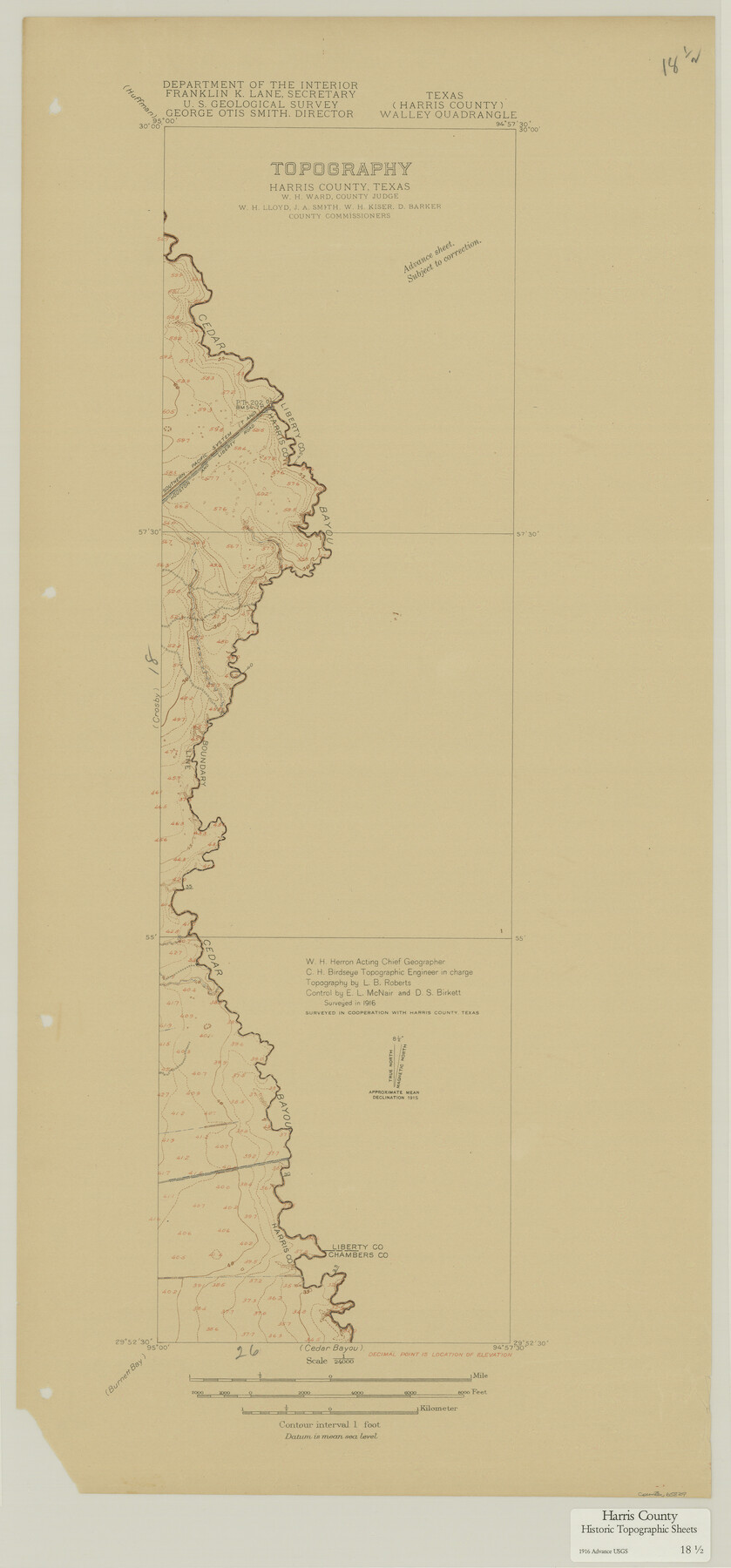
Harris County Historic Topographic 18 1/2
Walley Quadrangle
-
Map/Doc
65829
-
Collection
General Map Collection
-
Object Dates
1916 (Creation Date)
-
People and Organizations
U. S. Geological Survey (Publisher)
-
Counties
Harris
-
Subjects
Topographic
-
Height x Width
29.3 x 13.7 inches
74.4 x 34.8 cm
Part of: General Map Collection
Aransas County Working Sketch 13

Print $20.00
- Digital $50.00
Aransas County Working Sketch 13
1950
Size 26.0 x 42.2 inches
Map/Doc 67180
Tyler County Working Sketch 6

Print $20.00
- Digital $50.00
Tyler County Working Sketch 6
1934
Size 24.3 x 36.5 inches
Map/Doc 69476
Comanche County Sketch File 9

Print $4.00
- Digital $50.00
Comanche County Sketch File 9
1859
Size 6.0 x 9.1 inches
Map/Doc 19068
[Atchison, Topeka & Santa Fe from Paisano to south of Plata]
![64712, [Atchison, Topeka & Santa Fe from Paisano to south of Plata], General Map Collection](https://historictexasmaps.com/wmedia_w700/maps/64712-1.tif.jpg)
Print $40.00
- Digital $50.00
[Atchison, Topeka & Santa Fe from Paisano to south of Plata]
Size 32.3 x 121.5 inches
Map/Doc 64712
Terrell County Rolled Sketch 37

Print $20.00
- Digital $50.00
Terrell County Rolled Sketch 37
1940
Size 23.8 x 33.3 inches
Map/Doc 7941

Van Zandt County Sketch File 22

Print $6.00
- Digital $50.00
Van Zandt County Sketch File 22
Size 8.6 x 7.8 inches
Map/Doc 39432
Lynn County Boundary File 7b

Print $8.00
- Digital $50.00
Lynn County Boundary File 7b
Size 11.3 x 8.6 inches
Map/Doc 56651
Hale County Working Sketch 6

Print $40.00
- Digital $50.00
Hale County Working Sketch 6
1963
Size 68.9 x 38.8 inches
Map/Doc 63326
Brewster County Rolled Sketch 83A

Print $40.00
- Digital $50.00
Brewster County Rolled Sketch 83A
1946
Size 43.0 x 49.5 inches
Map/Doc 8930
Coke County Working Sketch 24

Print $20.00
- Digital $50.00
Coke County Working Sketch 24
1956
Size 28.7 x 31.1 inches
Map/Doc 68061
Travis County Working Sketch 64

Print $20.00
- Digital $50.00
Travis County Working Sketch 64
2000
Size 16.8 x 19.6 inches
Map/Doc 69448
You may also like
Eberstadt and Brock's Subdivisions of the West Half of Survey Number 187 Block 2 A. B. & M., Randall County Texas

Print $20.00
- Digital $50.00
Eberstadt and Brock's Subdivisions of the West Half of Survey Number 187 Block 2 A. B. & M., Randall County Texas
Size 14.9 x 30.7 inches
Map/Doc 91747
Flight Mission No. DCL-6C, Frame 177, Kenedy County

Print $20.00
- Digital $50.00
Flight Mission No. DCL-6C, Frame 177, Kenedy County
1943
Size 18.5 x 22.2 inches
Map/Doc 85989
Presidio County Working Sketch 12a

Print $20.00
- Digital $50.00
Presidio County Working Sketch 12a
1941
Size 23.7 x 43.1 inches
Map/Doc 71688
Bandera County Working Sketch 3

Print $20.00
- Digital $50.00
Bandera County Working Sketch 3
1914
Size 14.5 x 13.9 inches
Map/Doc 67596
1882 Map of the Texas & Pacific R-Y Reserve

Print $20.00
- Digital $50.00
1882 Map of the Texas & Pacific R-Y Reserve
1887
Size 44.6 x 29.8 inches
Map/Doc 83561
Kimble County Rolled Sketch 21

Print $20.00
- Digital $50.00
Kimble County Rolled Sketch 21
Size 10.5 x 18.2 inches
Map/Doc 6512
Map of the Houston & Texas Central Railway and connections

Print $20.00
- Digital $50.00
Map of the Houston & Texas Central Railway and connections
1871
Size 16.6 x 15.4 inches
Map/Doc 95753
Real County Rolled Sketch 4

Print $20.00
- Digital $50.00
Real County Rolled Sketch 4
1961
Size 18.7 x 20.4 inches
Map/Doc 7454
Wichita County Sketch File 25

Print $20.00
- Digital $50.00
Wichita County Sketch File 25
1919
Size 17.6 x 22.3 inches
Map/Doc 12685
Kenedy County Working Sketch 2b

Print $20.00
- Digital $50.00
Kenedy County Working Sketch 2b
1911
Size 17.7 x 33.3 inches
Map/Doc 70004

Sketch of H. & T. C. RR. Co. Lands on the Canadian River in Oldham and Wheeler Districts

Print $40.00
- Digital $50.00
Sketch of H. & T. C. RR. Co. Lands on the Canadian River in Oldham and Wheeler Districts
1884
Size 88.9 x 23.8 inches
Map/Doc 93193