Refugio County Rolled Sketch 5
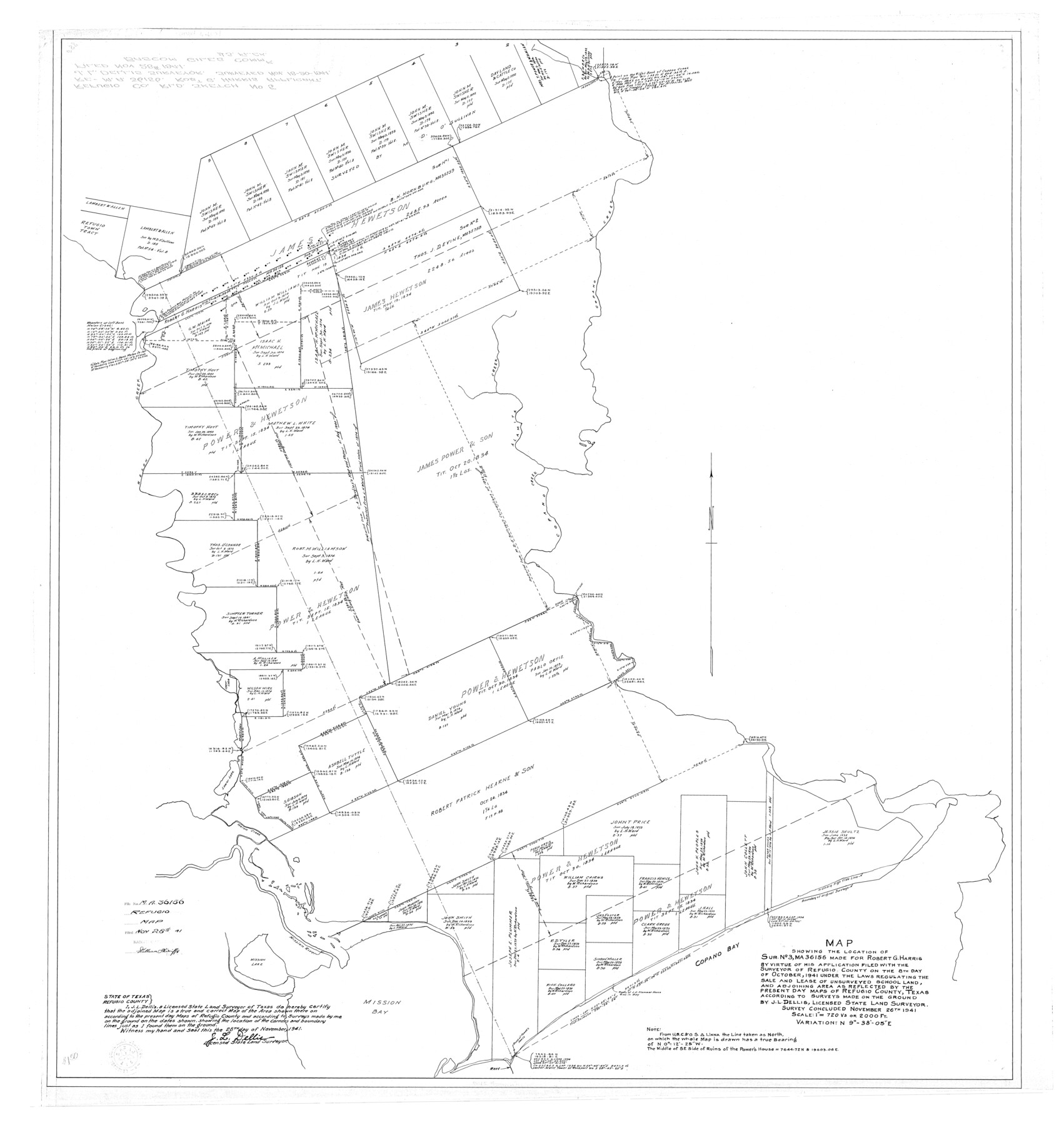
Map showing the location of sur. no. 3, MA-36156 made for Robert G. Harris
-
Map/Doc
9859
-
Collection
General Map Collection
-
Object Dates
1941/11/28 (Creation Date)
1941/11/28 (File Date)
-
People and Organizations
J.L. Dellis (Surveyor/Engineer)
-
Counties
Refugio
-
Subjects
Surveying Rolled Sketch
-
Height x Width
45.0 x 42.5 inches
114.3 x 108.0 cm
-
Scale
1" = 720 varas
Part of: General Map Collection
Tyler County Sketch File A

Print $5.00
- Digital $50.00
Tyler County Sketch File A
1849
Size 9.9 x 15.1 inches
Map/Doc 38603
Frio County Working Sketch 29

Print $20.00
- Digital $50.00
Frio County Working Sketch 29
2011
Size 35.9 x 40.6 inches
Map/Doc 89994
Galveston Entrance, Texas From a Trigonometrical Survey Under the direction of A.D. Bache Superintendent of the Survey of the Coast of the United States

Print $20.00
- Digital $50.00
Galveston Entrance, Texas From a Trigonometrical Survey Under the direction of A.D. Bache Superintendent of the Survey of the Coast of the United States
1853
Size 15.9 x 19.3 inches
Map/Doc 93998
Mitchell's New Intermediate Geography (Louisiana Edition)

Print $819.00
- Digital $50.00
Mitchell's New Intermediate Geography (Louisiana Edition)
1885
Size 12.5 x 10.0 inches
Map/Doc 93509
Polk County Sketch File 20

Print $4.00
- Digital $50.00
Polk County Sketch File 20
Size 6.1 x 8.2 inches
Map/Doc 34167
[Sketch for Mineral Application 24072, San Jacinto River]
![65599, [Sketch for Mineral Application 24072, San Jacinto River], General Map Collection](https://historictexasmaps.com/wmedia_w700/maps/65599.tif.jpg)
Print $20.00
- Digital $50.00
[Sketch for Mineral Application 24072, San Jacinto River]
1929
Size 23.5 x 18.0 inches
Map/Doc 65599
Upshur County Sketch File 13B

Print $20.00
- Digital $50.00
Upshur County Sketch File 13B
1936
Size 20.5 x 32.3 inches
Map/Doc 12504
Flight Mission No. CGN-1G, Frame 26, San Patricio County

Print $20.00
- Digital $50.00
Flight Mission No. CGN-1G, Frame 26, San Patricio County
1950
Size 9.4 x 9.4 inches
Map/Doc 87113
Fannin County Sketch File 16

Print $4.00
- Digital $50.00
Fannin County Sketch File 16
1873
Size 8.1 x 10.3 inches
Map/Doc 22469
Oldham County Rolled Sketch 7

Print $20.00
- Digital $50.00
Oldham County Rolled Sketch 7
Size 36.2 x 27.5 inches
Map/Doc 7173
Karnes County Working Sketch Graphic Index

Print $20.00
- Digital $50.00
Karnes County Working Sketch Graphic Index
1921
Size 45.0 x 40.3 inches
Map/Doc 76600
Blanco County Sketch File 10

Print $4.00
- Digital $50.00
Blanco County Sketch File 10
1853
Size 14.6 x 8.2 inches
Map/Doc 14588
You may also like

Harris County Sketch File 101

Print $104.00
- Digital $50.00
Harris County Sketch File 101
1991
Size 11.3 x 8.9 inches
Map/Doc 25873
Map of the Texas & Pacific Railway and connections

Print $20.00
- Digital $50.00
Map of the Texas & Pacific Railway and connections
1899
Size 17.9 x 36.6 inches
Map/Doc 95765
Geological Map of the Great East Texas Oil Fields

Print $20.00
- Digital $50.00
Geological Map of the Great East Texas Oil Fields
1921
Size 22.6 x 11.7 inches
Map/Doc 94271
Starr County Rolled Sketch 20

Print $20.00
- Digital $50.00
Starr County Rolled Sketch 20
1921
Size 23.6 x 15.4 inches
Map/Doc 7804
Map of Runnels County

Print $20.00
- Digital $50.00
Map of Runnels County
1898
Size 43.2 x 36.9 inches
Map/Doc 16803
Uvalde County Working Sketch 24

Print $20.00
- Digital $50.00
Uvalde County Working Sketch 24
1954
Size 21.7 x 23.3 inches
Map/Doc 72094
[Longview and Sabine Valley Railway Company Blocks in Reagan & Upton Counties, Texas]
![75789, [Longview and Sabine Valley Railway Company Blocks in Reagan & Upton Counties, Texas], Maddox Collection](https://historictexasmaps.com/wmedia_w700/maps/75789.tif.jpg)
Print $20.00
- Digital $50.00
[Longview and Sabine Valley Railway Company Blocks in Reagan & Upton Counties, Texas]
Size 17.5 x 18.3 inches
Map/Doc 75789
Map of Duval County

Print $20.00
- Digital $50.00
Map of Duval County
1876
Size 29.6 x 21.5 inches
Map/Doc 3498
Bailey County Sketch File 7

Print $8.00
- Digital $50.00
Bailey County Sketch File 7
1913
Size 14.0 x 8.7 inches
Map/Doc 13958
[Pencil sketch in vicinity of H. G. Sims, David F. Weff, B. Allen surveys]
![91853, [Pencil sketch in vicinity of H. G. Sims, David F. Weff, B. Allen surveys], Twichell Survey Records](https://historictexasmaps.com/wmedia_w700/maps/91853-1.tif.jpg)
Print $20.00
- Digital $50.00
[Pencil sketch in vicinity of H. G. Sims, David F. Weff, B. Allen surveys]
1924
Size 18.9 x 18.2 inches
Map/Doc 91853
