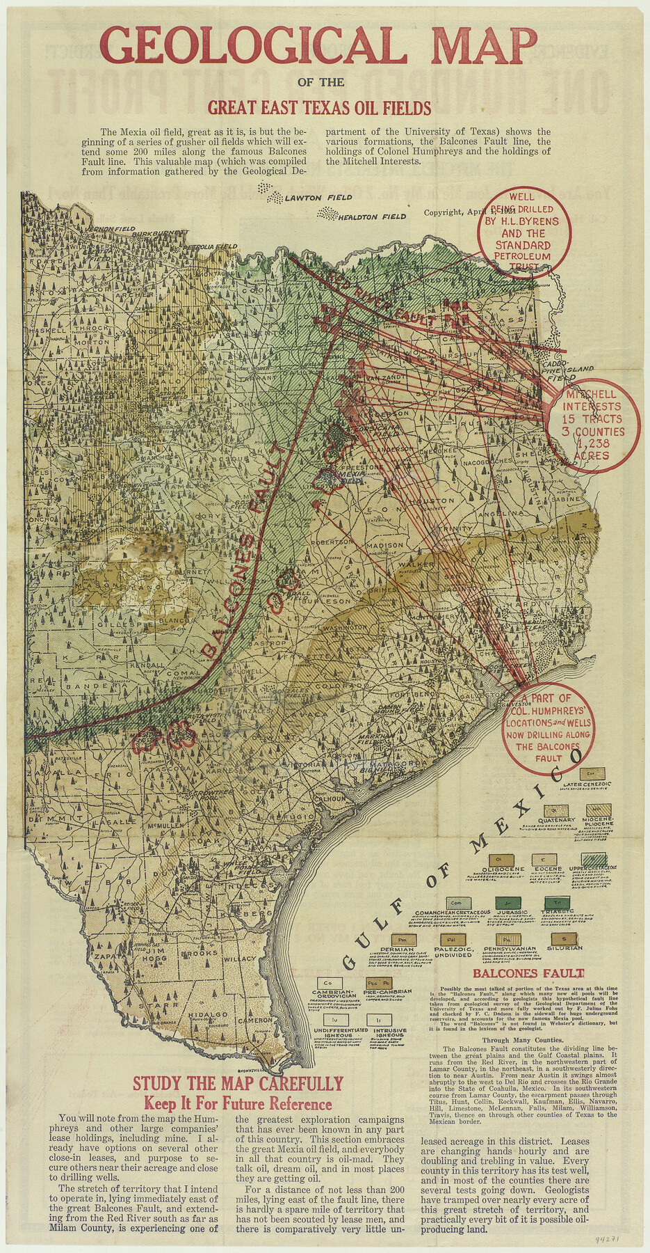
Geological Map of the Great East Texas Oil Fields
[recto]
-
Map/Doc
94271
-
Collection
General Map Collection
-
Object Dates
4/1/1921 (Creation Date)
-
People and Organizations
The Mitchell Interests (Publisher)
-
Subjects
Energy Surface State of Texas
-
Height x Width
22.6 x 11.7 inches
57.4 x 29.7 cm
-
Medium
paper, etching/engraving/lithograph
-
Comments
To view/download the advertising on verso, please click the "Download PDF" link above.
Part of: General Map Collection
Terrell County Sketch File 37

Print $4.00
- Digital $50.00
Terrell County Sketch File 37
Size 14.5 x 9.1 inches
Map/Doc 37999
Donley County Sketch File B11

Print $4.00
- Digital $50.00
Donley County Sketch File B11
1952
Size 11.5 x 9.0 inches
Map/Doc 21274
Chart of the Harbour of San [Luis]
![72763, Chart of the Harbour of San [Luis], General Map Collection](https://historictexasmaps.com/wmedia_w700/maps/72763.tif.jpg)
Print $20.00
- Digital $50.00
Chart of the Harbour of San [Luis]
1846
Size 27.7 x 18.3 inches
Map/Doc 72763
Map of Roberts County

Print $20.00
- Digital $50.00
Map of Roberts County
1932
Size 42.9 x 39.0 inches
Map/Doc 95626
Flight Mission No. CLL-3N, Frame 34, Willacy County

Print $20.00
- Digital $50.00
Flight Mission No. CLL-3N, Frame 34, Willacy County
1954
Size 18.6 x 22.2 inches
Map/Doc 87092
Pecos County Sketch File 21

Print $20.00
- Digital $50.00
Pecos County Sketch File 21
1886
Size 21.6 x 18.5 inches
Map/Doc 12161

Val Verde County Working Sketch 118

Print $40.00
- Digital $50.00
Val Verde County Working Sketch 118
2005
Size 29.6 x 50.0 inches
Map/Doc 83587
Boundary Between the United States & Mexico Agreed upon by the Joint Commission under the Treaty of Guadalupe Hidalgo

Print $4.00
- Digital $50.00
Boundary Between the United States & Mexico Agreed upon by the Joint Commission under the Treaty of Guadalupe Hidalgo
1853
Size 18.3 x 26.8 inches
Map/Doc 72881
Map of Bee County

Print $20.00
- Digital $50.00
Map of Bee County
1879
Size 25.3 x 22.8 inches
Map/Doc 3288
Terrell County

Print $40.00
- Digital $50.00
Terrell County
1931
Size 48.9 x 39.9 inches
Map/Doc 95651
Lipscomb County Rolled Sketch 5

Print $40.00
- Digital $50.00
Lipscomb County Rolled Sketch 5
Size 60.5 x 8.0 inches
Map/Doc 81427
You may also like
Terrell County Rolled Sketch 12

Print $20.00
- Digital $50.00
Terrell County Rolled Sketch 12
Size 37.1 x 31.5 inches
Map/Doc 7926
Jim Wells County Sketch File 1

Print $20.00
- Digital $50.00
Jim Wells County Sketch File 1
1931
Size 22.9 x 22.1 inches
Map/Doc 11889
The Land Offices. No. 8, Mina, December 22, 1836

Print $20.00
The Land Offices. No. 8, Mina, December 22, 1836
2020
Size 19.9 x 21.7 inches
Map/Doc 96421
Haskell County Rolled Sketch 15

Print $20.00
- Digital $50.00
Haskell County Rolled Sketch 15
1991
Size 12.7 x 18.4 inches
Map/Doc 6173
Edwards County Working Sketch 96

Print $20.00
- Digital $50.00
Edwards County Working Sketch 96
1969
Size 25.1 x 34.1 inches
Map/Doc 68972

Copy of Surveyor's Field Book, Morris Browning - In Blocks 7, 5 & 4, I&GNRRCo., Hutchinson and Carson Counties, Texas

Print $2.00
- Digital $50.00
Copy of Surveyor's Field Book, Morris Browning - In Blocks 7, 5 & 4, I&GNRRCo., Hutchinson and Carson Counties, Texas
1888
Size 7.0 x 8.8 inches
Map/Doc 62276
Crockett County Working Sketch 25

Print $20.00
- Digital $50.00
Crockett County Working Sketch 25
1921
Size 23.5 x 17.6 inches
Map/Doc 68358
[Sketch showing Blocks B5, B6 and G.&M. Block 5 north of Capitol Land]
![92989, [Sketch showing Blocks B5, B6 and G.&M. Block 5 north of Capitol Land], Twichell Survey Records](https://historictexasmaps.com/wmedia_w700/maps/92989-1.tif.jpg)
Print $20.00
- Digital $50.00
[Sketch showing Blocks B5, B6 and G.&M. Block 5 north of Capitol Land]
Size 38.4 x 20.9 inches
Map/Doc 92989
Flight Mission No. BRA-16M, Frame 170, Jefferson County

Print $20.00
- Digital $50.00
Flight Mission No. BRA-16M, Frame 170, Jefferson County
1953
Size 18.6 x 22.4 inches
Map/Doc 85768
Flight Mission No. DCL-6C, Frame 174, Kenedy County

Print $20.00
- Digital $50.00
Flight Mission No. DCL-6C, Frame 174, Kenedy County
1943
Size 18.7 x 22.3 inches
Map/Doc 85986
Cameron County Rolled Sketch 28

Print $40.00
- Digital $50.00
Cameron County Rolled Sketch 28
1986
Size 36.5 x 48.3 inches
Map/Doc 8575