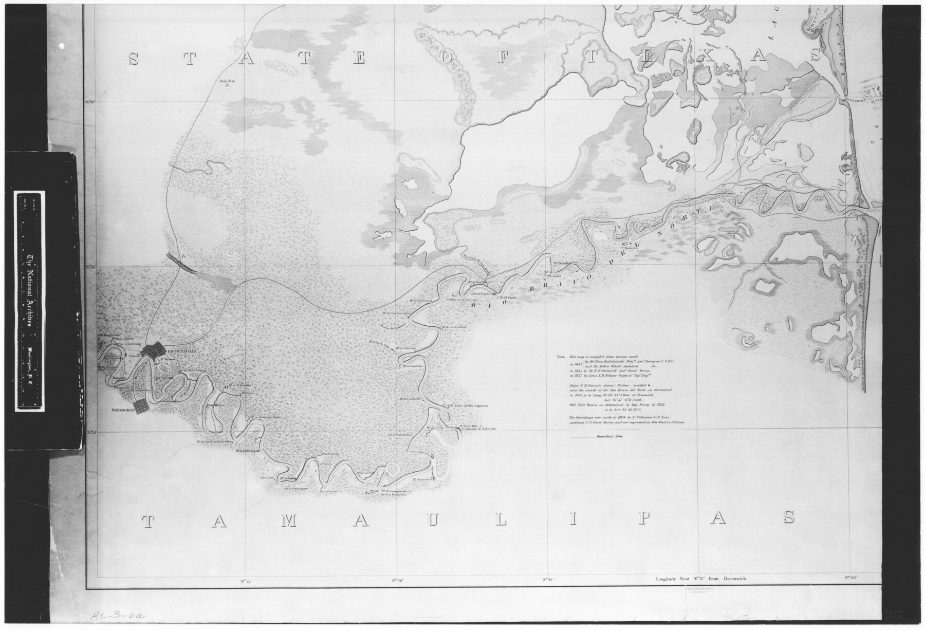
Boundary Between the United States & Mexico Agreed upon by the Joint Commission under the Treaty of Guadalupe Hidalgo
RL-3-6a
-
Map/Doc
72881
-
Collection
General Map Collection
-
Object Dates
1853 (Creation Date)
-
People and Organizations
Department of the Interior (Publisher)
Selmar Siebert (Printer)
Corps of Topogrpahical Engineers (Author)
Francis Herbst (Draftsman)
Charles Radziminski (Surveyor/Engineer)
Arthur Schott (Surveyor/Engineer)
-
Subjects
Texas Boundaries
-
Height x Width
18.3 x 26.8 inches
46.5 x 68.1 cm
-
Comments
B/W photostat copy from National Archives in multiple pieces.
Part of: General Map Collection
Presidio County Working Sketch 14

Print $20.00
- Digital $50.00
Presidio County Working Sketch 14
1942
Size 10.9 x 17.7 inches
Map/Doc 71690
La Salle County Rolled Sketch 3

Print $20.00
- Digital $50.00
La Salle County Rolled Sketch 3
1937
Size 32.6 x 38.9 inches
Map/Doc 6568
Tyler County Working Sketch 5

Print $20.00
- Digital $50.00
Tyler County Working Sketch 5
1928
Size 19.4 x 21.2 inches
Map/Doc 69475
Duval County Rolled Sketch 27

Print $40.00
- Digital $50.00
Duval County Rolled Sketch 27
Size 14.6 x 50.6 inches
Map/Doc 8814
Flight Mission No. DCL-4C, Frame 68, Kenedy County

Print $20.00
- Digital $50.00
Flight Mission No. DCL-4C, Frame 68, Kenedy County
1943
Size 18.7 x 22.3 inches
Map/Doc 85813
Current Miscellaneous File 112

Print $138.00
- Digital $50.00
Current Miscellaneous File 112
Size 11.3 x 8.7 inches
Map/Doc 74718
Panola County Working Sketch 17

Print $40.00
- Digital $50.00
Panola County Working Sketch 17
1945
Map/Doc 71426
Flight Mission No. CGI-1N, Frame 181, Cameron County

Print $20.00
- Digital $50.00
Flight Mission No. CGI-1N, Frame 181, Cameron County
1955
Size 18.7 x 22.2 inches
Map/Doc 84516
Wilson County Working Sketch 3

Print $20.00
- Digital $50.00
Wilson County Working Sketch 3
1952
Size 33.6 x 33.2 inches
Map/Doc 72583
Wichita County Rolled Sketch 18

Print $20.00
- Digital $50.00
Wichita County Rolled Sketch 18
1923
Size 25.7 x 38.0 inches
Map/Doc 8254
Willacy County Sketch File 1a

Print $272.00
- Digital $50.00
Willacy County Sketch File 1a
1977
Size 8.3 x 3.7 inches
Map/Doc 40239
Llano County Sketch File 19

Print $16.00
- Digital $50.00
Llano County Sketch File 19
1961
Size 14.2 x 8.7 inches
Map/Doc 30397
You may also like
[Atchison, Topeka & Santa Fe from Paisano to south of Plata]
![64709, [Atchison, Topeka & Santa Fe from Paisano to south of Plata], General Map Collection](https://historictexasmaps.com/wmedia_w700/maps/64709.tif.jpg)
Print $40.00
- Digital $50.00
[Atchison, Topeka & Santa Fe from Paisano to south of Plata]
Size 32.3 x 120.8 inches
Map/Doc 64709
Tom Green County Working Sketch 10

Print $20.00
- Digital $50.00
Tom Green County Working Sketch 10
1959
Size 22.0 x 32.7 inches
Map/Doc 69379
[Block 37, Townships 1 and 2 North]
![91344, [Block 37, Townships 1 and 2 North], Twichell Survey Records](https://historictexasmaps.com/wmedia_w700/maps/91344-1.tif.jpg)
Print $20.00
- Digital $50.00
[Block 37, Townships 1 and 2 North]
Size 13.9 x 34.3 inches
Map/Doc 91344
Fractional Township No. 8 South Range No. 15 East of the Indian Meridian, Indian Territory

Print $20.00
- Digital $50.00
Fractional Township No. 8 South Range No. 15 East of the Indian Meridian, Indian Territory
1896
Size 19.1 x 24.3 inches
Map/Doc 75227
Upton County Working Sketch 21

Print $20.00
- Digital $50.00
Upton County Working Sketch 21
1950
Size 33.8 x 36.0 inches
Map/Doc 69517
Burnet County Rolled Sketch 2

Print $20.00
- Digital $50.00
Burnet County Rolled Sketch 2
1948
Size 15.5 x 30.5 inches
Map/Doc 5354
Brewster County Working Sketch 110

Print $40.00
- Digital $50.00
Brewster County Working Sketch 110
1982
Size 48.9 x 40.1 inches
Map/Doc 67710
Jim Hogg County Working Sketch 4

Print $20.00
- Digital $50.00
Jim Hogg County Working Sketch 4
1939
Size 20.9 x 25.4 inches
Map/Doc 66590
[Right of Way & Track Map, The Texas & Pacific Ry. Co. Main Line]
![64676, [Right of Way & Track Map, The Texas & Pacific Ry. Co. Main Line], General Map Collection](https://historictexasmaps.com/wmedia_w700/maps/64676.tif.jpg)
Print $20.00
- Digital $50.00
[Right of Way & Track Map, The Texas & Pacific Ry. Co. Main Line]
Size 11.0 x 18.6 inches
Map/Doc 64676
Duval County Boundary File 5

Print $4.00
- Digital $50.00
Duval County Boundary File 5
Size 7.7 x 11.9 inches
Map/Doc 52769
Freestone County Working Sketch 1

Print $20.00
- Digital $50.00
Freestone County Working Sketch 1
1913
Size 20.2 x 27.2 inches
Map/Doc 69243
Bee County Sketch File 12

Print $4.00
- Digital $50.00
Bee County Sketch File 12
1876
Size 8.2 x 9.8 inches
Map/Doc 14293