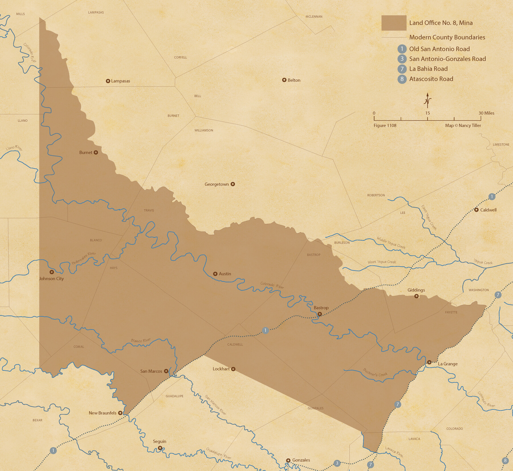
The Land Offices. No. 8, Mina, December 22, 1836
Figure No. 1108 from 'A Boundary Atlas of Texas, 1821-1845' by Jim Tiller
-
Map/Doc
96421
-
Collection
Nancy and Jim Tiller Digital Collection
-
Object Dates
2020/1/1 (Creation Date)
-
People and Organizations
Jim Tiller (Author)
Nancy Tiller (Cartographer)
Gang Gong (GIS Professional)
-
Subjects
Atlas Republic of Texas Texas Boundaries
-
Height x Width
19.9 x 21.7 inches
50.6 x 55.1 cm
-
Medium
digital image
-
Comments
To purchase a digital PDF copy of "A Boundary Atlas of Texas, 1821-1845" see 96437.
Part of: Nancy and Jim Tiller Digital Collection
The Mexican Municipality of Matagorda. December 28, 1834

Print $20.00
The Mexican Municipality of Matagorda. December 28, 1834
2020
Size 15.9 x 21.7 inches
Map/Doc 96026
The Republic County of Austin. Proposed, Late Fall 1837

Print $20.00
The Republic County of Austin. Proposed, Late Fall 1837
2020
Size 14.8 x 21.7 inches
Map/Doc 96080
The Republic County of Nacogdoches. December 29, 1845

Print $20.00
The Republic County of Nacogdoches. December 29, 1845
2020
Size 15.9 x 21.8 inches
Map/Doc 96250
The Fisher-Miller Colony. June 7, 1842

Print $20.00
The Fisher-Miller Colony. June 7, 1842
2020
Size 13.8 x 21.7 inches
Map/Doc 96358
The Mexican Department of Nacogdoches. May 6, 1833

Print $20.00
The Mexican Department of Nacogdoches. May 6, 1833
2020
Size 18.5 x 21.7 inches
Map/Doc 95973
The Republic County of Montgomery. January 21, 1841

Print $20.00
The Republic County of Montgomery. January 21, 1841
2020
Size 19.9 x 21.7 inches
Map/Doc 96238
Exeter and Wilson Empresario Colony. September 23, 1828

Print $20.00
Exeter and Wilson Empresario Colony. September 23, 1828
2020
Size 15.5 x 21.7 inches
Map/Doc 95994
The Republic County of Bastrop. December 29, 1845

Print $20.00
The Republic County of Bastrop. December 29, 1845
2020
Size 14.8 x 21.7 inches
Map/Doc 96092
Republic Counties. January 1, 1845

Print $20.00
Republic Counties. January 1, 1845
2020
Size 24.5 x 21.7 inches
Map/Doc 96318
Refinement of the Line by County Surveyors from Gonzales and Victoria Counties, April 14, 1838

Print $20.00
Refinement of the Line by County Surveyors from Gonzales and Victoria Counties, April 14, 1838
2020
Size 24.9 x 21.7 inches
Map/Doc 96379
The Republic County of Jackson. January 19, 1841

Print $20.00
The Republic County of Jackson. January 19, 1841
2020
Size 15.6 x 21.8 inches
Map/Doc 96188
Republic Counties. January 1, 1839

Print $20.00
Republic Counties. January 1, 1839
2020
Size 24.5 x 21.7 inches
Map/Doc 96312
You may also like
Red River, Bois D'Arc Creek Floodway Sheet No. 4

Print $20.00
- Digital $50.00
Red River, Bois D'Arc Creek Floodway Sheet No. 4
1917
Size 20.3 x 28.9 inches
Map/Doc 69659
Palo Pinto County Sketch File 8

Print $40.00
- Digital $50.00
Palo Pinto County Sketch File 8
Size 15.3 x 15.6 inches
Map/Doc 33400
Wood County Boundary File 7

Print $34.00
- Digital $50.00
Wood County Boundary File 7
Size 13.3 x 8.8 inches
Map/Doc 60187
Fisher County Rolled Sketch 5

Print $20.00
- Digital $50.00
Fisher County Rolled Sketch 5
1961
Size 39.1 x 33.7 inches
Map/Doc 8890
Motley County Sketch File 6 (N)

Print $20.00
- Digital $50.00
Motley County Sketch File 6 (N)
1900
Size 14.0 x 8.6 inches
Map/Doc 32004
Map of Fisher & Miller's Colony made from the records in the office of the District Surveyor of Bexar comprising also all the recent surveys

Print $20.00
- Digital $50.00
Map of Fisher & Miller's Colony made from the records in the office of the District Surveyor of Bexar comprising also all the recent surveys
1855
Size 22.6 x 36.2 inches
Map/Doc 633
Brewster County Sketch File 54

Print $4.00
- Digital $50.00
Brewster County Sketch File 54
1963
Size 11.0 x 8.5 inches
Map/Doc 16383
Flight Mission No. DQN-5K, Frame 78, Calhoun County

Print $20.00
- Digital $50.00
Flight Mission No. DQN-5K, Frame 78, Calhoun County
1953
Size 18.6 x 22.3 inches
Map/Doc 84411
Anderson County Sketch File 12

Print $6.00
- Digital $50.00
Anderson County Sketch File 12
1852
Size 13.7 x 8.3 inches
Map/Doc 12771
Flight Mission No. BRA-9M, Frame 61, Jefferson County

Print $20.00
- Digital $50.00
Flight Mission No. BRA-9M, Frame 61, Jefferson County
1953
Size 18.7 x 22.4 inches
Map/Doc 85644
Hutchinson County Working Sketch 26

Print $20.00
- Digital $50.00
Hutchinson County Working Sketch 26
1978
Size 27.5 x 23.4 inches
Map/Doc 66386
Kimble County Sketch File B

Print $22.00
- Digital $50.00
Kimble County Sketch File B
Size 14.3 x 12.7 inches
Map/Doc 28963