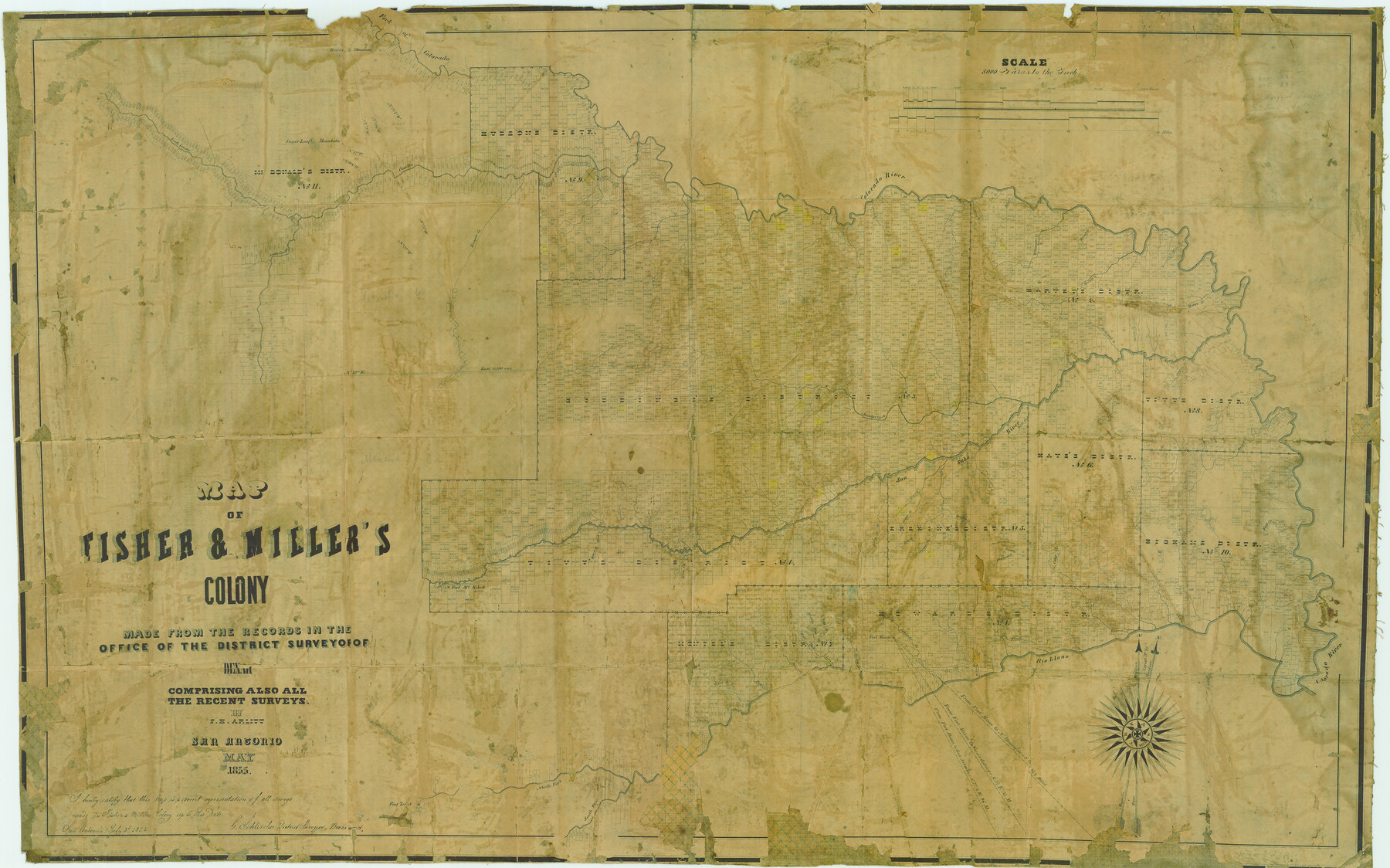
Map of Fisher & Miller's Colony made from the records in the office of the District Surveyor of Bexar comprising also all the recent surveys
-
Map/Doc
633
-
Collection
Maddox Collection
-
Object Dates
1855 (Creation Date)
1855/7/3 (File Date)
-
People and Organizations
Theodore Fisher (Printer)
G. Schleicher (Surveyor/Engineer)
F.H. Arlitt (Draftsman)
-
Counties
San Saba McCulloch Concho Mason Menard Tom Green
-
Subjects
Colony
-
Height x Width
22.6 x 36.2 inches
57.4 x 91.9 cm
-
Medium
paper, etching/engraving/lithograph
-
Scale
1" = 8000 varas
-
Comments
Adopted in 2006 in Memory of Charles Wallace Pratt by loved ones and conservation funded in 2007.
-
Features
Middle Fork of Leon Creek
Fort McKavett
Rough Creek
Marble Creek
Fall Creek
Cold Creek
Fernando Creek
Rio Llano
Elm Creek
Comanche Creek
Fort Mason
Honey Creek
Leon Creek
Salt Fork of Leon Creek
Howard's Creek
East Fork of Leon Creek
Julios Creek
Bear Creek
Ionia Creek
Bluff Creek
North Fork of Llano River
South Fork of Llano River
South Concho River
Concho River
Kicapoo [sic] Creek
San Saba River
Salinas Creek
Richland Creek
Sugar Loaf Mountain
Round Mountain
Red Fork of Colorado
Colorado River
Deep Creek
Salt Creek
Wilbargers Creek
Mound Creek
Spring Creek
Waco Creek
Horse Creek
China Creek
North Concho River
Bonnet Creek
Brady's Creek
Simpson Creek
Deer Creek
Buffalo Creek
Tiger Creek
Grape Creek
Hickory Creek
Cherokee Creek
Trout Creek
Sad Branch [of Trout Creek]
Katemsys Creek
Part of: Maddox Collection
Sherman County, Texas

Print $20.00
- Digital $50.00
Sherman County, Texas
1888
Size 23.1 x 18.5 inches
Map/Doc 754
Copy of Sketch in Nacogdoches Scrip 1392

Print $20.00
- Digital $50.00
Copy of Sketch in Nacogdoches Scrip 1392
1890
Size 25.3 x 14.7 inches
Map/Doc 75780
Map of the C.C. Browning survey 412 enlarged from General Land Office map of the west part of Travis County, Texas

Print $3.00
- Digital $50.00
Map of the C.C. Browning survey 412 enlarged from General Land Office map of the west part of Travis County, Texas
1920
Size 11.3 x 9.1 inches
Map/Doc 10752
Graham's Addition Being a Subdivision of a Portion of Lot No. 1 of Spear League

Print $20.00
- Digital $50.00
Graham's Addition Being a Subdivision of a Portion of Lot No. 1 of Spear League
1914
Size 13.6 x 33.0 inches
Map/Doc 542
[Vague Sketches in Brooks County, Texas]
![83352, [Vague Sketches in Brooks County, Texas], Maddox Collection](https://historictexasmaps.com/wmedia_w700/maps/83352.tif.jpg)
Print $20.00
- Digital $50.00
[Vague Sketches in Brooks County, Texas]
1906
Size 17.8 x 19.9 inches
Map/Doc 83352
Map of Alabama and Texas Cattle Co's Pasture

Print $20.00
- Digital $50.00
Map of Alabama and Texas Cattle Co's Pasture
Size 17.6 x 18.1 inches
Map/Doc 5064
Map showing lands of D. Sullivan known as Santa Rosa Ranch situated in Cameron and Hidalgo Counties, Texas

Print $20.00
- Digital $50.00
Map showing lands of D. Sullivan known as Santa Rosa Ranch situated in Cameron and Hidalgo Counties, Texas
1905
Size 26.2 x 23.2 inches
Map/Doc 4455
Survey for H.A. Wroe

Print $20.00
- Digital $50.00
Survey for H.A. Wroe
Size 19.6 x 10.4 inches
Map/Doc 601
Ward County, Texas

Print $20.00
- Digital $50.00
Ward County, Texas
1888
Size 20.2 x 25.5 inches
Map/Doc 657
Map of part of Presidio Co. Texas

Print $20.00
- Digital $50.00
Map of part of Presidio Co. Texas
Size 16.5 x 21.3 inches
Map/Doc 75769
Map of Public Land on Mustang Island

Print $20.00
- Digital $50.00
Map of Public Land on Mustang Island
Size 21.9 x 17.5 inches
Map/Doc 82315
Sketch showing position of Asylum Lands Blk. 4, H. & T. C. R.R. Co. & river surveys on north side of Middle Concho, Tom Green Co.

Print $20.00
- Digital $50.00
Sketch showing position of Asylum Lands Blk. 4, H. & T. C. R.R. Co. & river surveys on north side of Middle Concho, Tom Green Co.
Size 14.4 x 20.6 inches
Map/Doc 388
You may also like
El Paso County Rolled Sketch 16

Print $40.00
- Digital $50.00
El Paso County Rolled Sketch 16
1885
Size 21.5 x 52.0 inches
Map/Doc 8855
Williamson County Sketch File 31

Print $14.00
- Digital $50.00
Williamson County Sketch File 31
1991
Size 11.2 x 8.4 inches
Map/Doc 40386
Caldwell County Working Sketch 12

Print $20.00
- Digital $50.00
Caldwell County Working Sketch 12
1979
Size 47.7 x 44.2 inches
Map/Doc 67842
[Surveys along the Brazos River]
![71, [Surveys along the Brazos River], General Map Collection](https://historictexasmaps.com/wmedia_w700/maps/71.tif.jpg)
Print $3.00
- Digital $50.00
[Surveys along the Brazos River]
1840
Size 16.2 x 9.4 inches
Map/Doc 71
Flight Mission No. DQN-7K, Frame 6, Calhoun County

Print $20.00
- Digital $50.00
Flight Mission No. DQN-7K, Frame 6, Calhoun County
1953
Size 18.8 x 22.4 inches
Map/Doc 84457
Lynn County Boundary File 7a

Print $8.00
- Digital $50.00
Lynn County Boundary File 7a
Size 14.3 x 8.8 inches
Map/Doc 56647
Montgomery County Working Sketch 71

Print $20.00
- Digital $50.00
Montgomery County Working Sketch 71
1979
Size 37.2 x 29.8 inches
Map/Doc 71178
Maps of Gulf Intracoastal Waterway, Texas - Sabine River to the Rio Grande and connecting waterways including ship channels

Print $20.00
- Digital $50.00
Maps of Gulf Intracoastal Waterway, Texas - Sabine River to the Rio Grande and connecting waterways including ship channels
1966
Size 14.5 x 22.2 inches
Map/Doc 61969
Jefferson County Sketch File 51

Print $10.00
- Digital $50.00
Jefferson County Sketch File 51
Size 10.0 x 6.7 inches
Map/Doc 28249
Flight Mission No. DQN-2K, Frame 80, Calhoun County

Print $20.00
- Digital $50.00
Flight Mission No. DQN-2K, Frame 80, Calhoun County
1953
Size 18.4 x 22.2 inches
Map/Doc 84272
Intracoastal Waterway in Texas - Corpus Christi to Point Isabel including Arroyo Colorado to Mo. Pac. R.R. Bridge Near Harlingen

Print $20.00
- Digital $50.00
Intracoastal Waterway in Texas - Corpus Christi to Point Isabel including Arroyo Colorado to Mo. Pac. R.R. Bridge Near Harlingen
1933
Size 28.2 x 41.0 inches
Map/Doc 61854
Flight Mission No. DQN-5K, Frame 45, Calhoun County

Print $20.00
- Digital $50.00
Flight Mission No. DQN-5K, Frame 45, Calhoun County
1953
Size 18.4 x 22.1 inches
Map/Doc 84390