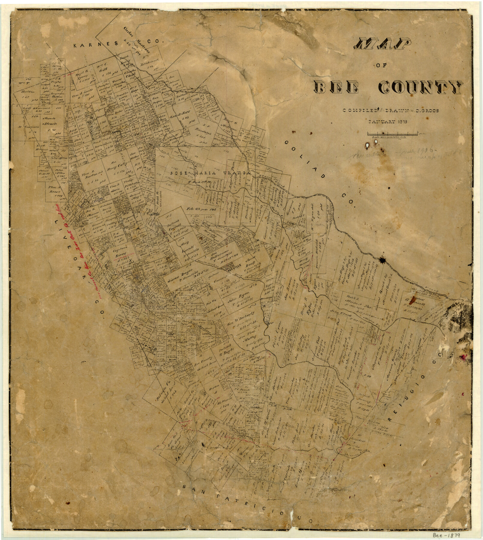
Map of Bee County
-
Map/Doc
3288
-
Collection
General Map Collection
-
Object Dates
1879 (Creation Date)
-
People and Organizations
Texas General Land Office (Publisher)
Otto Groos (Compiler)
Otto Groos (Draftsman)
-
Counties
Bee
-
Subjects
County
-
Height x Width
25.3 x 22.8 inches
64.3 x 57.9 cm
-
Features
Aransas River
La Yesca Creek
La Bata Creek
Bullhead Creek
Elm Creek
Buzzard Creek
Trout Creek
Talpacate Creek
East Aransas Creek
Medio Creek
Spring Creek
West Aranzas [sic] River
Beeville
Paesta Creek
Blanco Creek
Toro Creek
Puenta de la Piedra Creek
Part of: General Map Collection
Pecos County Working Sketch 73

Print $40.00
- Digital $50.00
Pecos County Working Sketch 73
1957
Size 110.6 x 38.7 inches
Map/Doc 71545
Gaines County

Print $40.00
- Digital $50.00
Gaines County
1902
Size 38.9 x 49.7 inches
Map/Doc 66832
Galveston County NRC Article 33.136 Sketch 49

Print $24.00
- Digital $50.00
Galveston County NRC Article 33.136 Sketch 49
2007
Size 24.0 x 36.0 inches
Map/Doc 94663
Ellis County Working Sketch Graphic Index

Print $20.00
- Digital $50.00
Ellis County Working Sketch Graphic Index
1943
Size 43.1 x 47.7 inches
Map/Doc 76535
Crosby County Sketch File 11b

Print $20.00
- Digital $50.00
Crosby County Sketch File 11b
1890
Size 17.2 x 15.6 inches
Map/Doc 11247
Dexter Quadrangle

Print $20.00
- Digital $50.00
Dexter Quadrangle
1999
Size 35.4 x 23.4 inches
Map/Doc 97361
Eastland County Sketch File 21

Print $8.00
- Digital $50.00
Eastland County Sketch File 21
1990
Size 11.3 x 8.8 inches
Map/Doc 21622
Bosque County Working Sketch 33

Print $20.00
- Digital $50.00
Bosque County Working Sketch 33
2016
Size 37.0 x 25.0 inches
Map/Doc 93980
Presidio County Sketch File 101

Print $20.00
- Digital $50.00
Presidio County Sketch File 101
1888
Size 21.1 x 20.3 inches
Map/Doc 11725
Greer County Sketch File 8

Print $20.00
- Digital $50.00
Greer County Sketch File 8
Size 16.7 x 23.6 inches
Map/Doc 11584
Val Verde County Working Sketch 13

Print $20.00
- Digital $50.00
Val Verde County Working Sketch 13
1922
Size 24.8 x 25.3 inches
Map/Doc 72148
Comanche County Working Sketch 31

Print $20.00
- Digital $50.00
Comanche County Working Sketch 31
1991
Size 28.4 x 24.2 inches
Map/Doc 68165
You may also like
[Section of] El Nuevo Mexico y Tierras Adyacentes Mapa Levantado para la demarcacion de los Limites de los Dominios Españoles y de los Estados Unidos

[Section of] El Nuevo Mexico y Tierras Adyacentes Mapa Levantado para la demarcacion de los Limites de los Dominios Españoles y de los Estados Unidos
1811
Size 17.9 x 26.7 inches
Map/Doc 97484

[Highway Map of the State of Texas]
![5039, [Highway Map of the State of Texas], Maddox Collection](https://historictexasmaps.com/wmedia_w700/maps/5039-1.tif.jpg)
Print $20.00
- Digital $50.00
[Highway Map of the State of Texas]
1923
Size 44.7 x 46.7 inches
Map/Doc 5039
Flight Mission No. CGI-1N, Frame 171, Cameron County

Print $20.00
- Digital $50.00
Flight Mission No. CGI-1N, Frame 171, Cameron County
1955
Size 18.5 x 22.2 inches
Map/Doc 84506
Garza County Sketch File 21

Print $4.00
- Digital $50.00
Garza County Sketch File 21
1906
Size 14.4 x 8.7 inches
Map/Doc 24078
Blanco County Sketch File 34

Print $4.00
- Digital $50.00
Blanco County Sketch File 34
1879
Size 12.7 x 8.2 inches
Map/Doc 14637
Map of Presidio County, Texas

Print $40.00
- Digital $50.00
Map of Presidio County, Texas
Size 42.7 x 82.1 inches
Map/Doc 82050
Medina County Sketch File 22

Print $38.00
- Digital $50.00
Medina County Sketch File 22
2007
Size 11.0 x 8.5 inches
Map/Doc 93633
Brazoria County Working Sketch 15

Print $20.00
- Digital $50.00
Brazoria County Working Sketch 15
1940
Size 18.2 x 38.6 inches
Map/Doc 67500
Hidalgo County Working Sketch 5

Print $20.00
- Digital $50.00
Hidalgo County Working Sketch 5
1956
Size 38.1 x 37.9 inches
Map/Doc 66182
[Area in the vicinity of the Mary Fury survey south of H. T. & B. RR. Co. surveys 125 and 126]
![90933, [Area in the vicinity of the Mary Fury survey south of H. T. & B. RR. Co. surveys 125 and 126], Twichell Survey Records](https://historictexasmaps.com/wmedia_w700/maps/90933-1.tif.jpg)
Print $20.00
- Digital $50.00
[Area in the vicinity of the Mary Fury survey south of H. T. & B. RR. Co. surveys 125 and 126]
Size 13.5 x 21.7 inches
Map/Doc 90933
[State Line from Southeast New Mexico to Yoakum County]
![92013, [State Line from Southeast New Mexico to Yoakum County], Twichell Survey Records](https://historictexasmaps.com/wmedia_w700/maps/92013-1.tif.jpg)
Print $20.00
- Digital $50.00
[State Line from Southeast New Mexico to Yoakum County]
Size 32.3 x 11.7 inches
Map/Doc 92013