Blanco County Sketch File 34
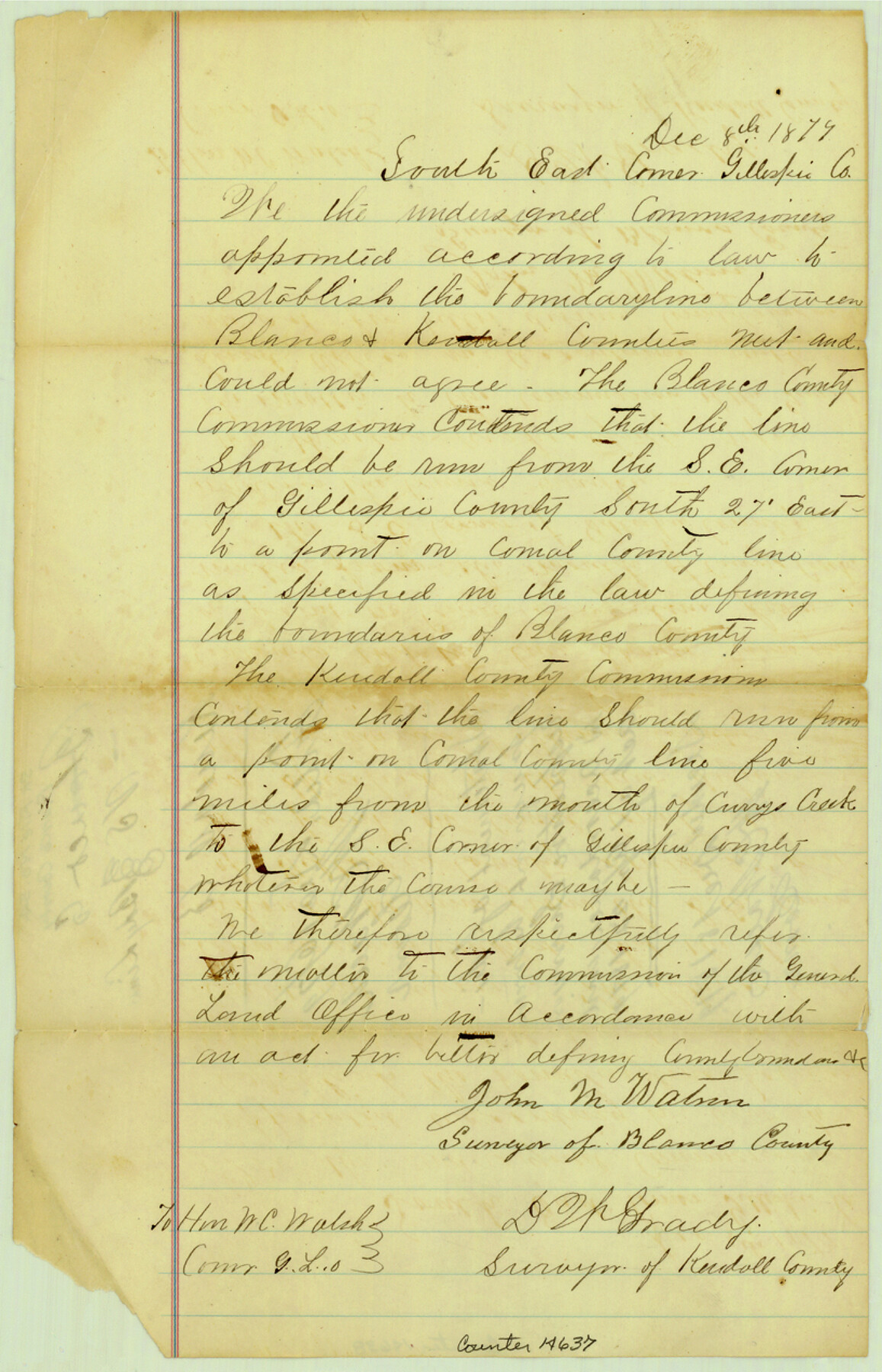
[Statement of disagreement between respective surveyors regarding Blanco-Kendall County line]
-
Map/Doc
14637
-
Collection
General Map Collection
-
Object Dates
1879/12/8 (Creation Date)
1879/12/16 (File Date)
-
People and Organizations
D.W. Grady (Surveyor/Engineer)
John M. Watson (Surveyor/Engineer)
W.C. Walsh (GLO Commissioner)
-
Counties
Blanco Kendall
-
Subjects
Surveying Sketch File
-
Height x Width
12.7 x 8.2 inches
32.3 x 20.8 cm
-
Medium
paper, manuscript
-
Comments
In accordance with an Act of April 22, 1879. Decided December 18, 1879.
-
Features
Curry's Creek
Part of: General Map Collection
Flight Mission No. CGI-3N, Frame 74, Cameron County

Print $20.00
- Digital $50.00
Flight Mission No. CGI-3N, Frame 74, Cameron County
1954
Size 18.7 x 22.2 inches
Map/Doc 84568
Flight Mission No. CRC-4R, Frame 183, Chambers County

Print $20.00
- Digital $50.00
Flight Mission No. CRC-4R, Frame 183, Chambers County
1956
Size 18.5 x 22.2 inches
Map/Doc 84934
Atascosa County Sketch File 27c

Print $12.00
- Digital $50.00
Atascosa County Sketch File 27c
1876
Size 12.7 x 8.4 inches
Map/Doc 13806
Hale County Sketch File 27

Print $20.00
- Digital $50.00
Hale County Sketch File 27
Size 12.1 x 28.5 inches
Map/Doc 11598
Andrews County Rolled Sketch 37

Print $20.00
- Digital $50.00
Andrews County Rolled Sketch 37
Size 29.1 x 19.8 inches
Map/Doc 77179
King County Boundary File 2

Print $54.00
- Digital $50.00
King County Boundary File 2
Size 8.8 x 7.7 inches
Map/Doc 64887
Flight Mission No. BRA-16M, Frame 54, Jefferson County

Print $20.00
- Digital $50.00
Flight Mission No. BRA-16M, Frame 54, Jefferson County
1953
Size 18.5 x 22.5 inches
Map/Doc 85671
Flight Mission No. BQR-22K, Frame 43, Brazoria County

Print $20.00
- Digital $50.00
Flight Mission No. BQR-22K, Frame 43, Brazoria County
1953
Size 18.6 x 22.3 inches
Map/Doc 84127
Flight Mission No. CRE-3R, Frame 42, Jackson County

Print $20.00
- Digital $50.00
Flight Mission No. CRE-3R, Frame 42, Jackson County
1956
Size 18.6 x 22.4 inches
Map/Doc 85389
Val Verde County Sketch File 19

Print $4.00
- Digital $50.00
Val Verde County Sketch File 19
1858
Size 13.0 x 8.1 inches
Map/Doc 39229
Jeff Davis County Sketch File 33

Print $40.00
- Digital $50.00
Jeff Davis County Sketch File 33
1944
Size 48.2 x 26.0 inches
Map/Doc 10507
Brewster County Working Sketch 81

Print $20.00
- Digital $50.00
Brewster County Working Sketch 81
1972
Size 45.9 x 26.7 inches
Map/Doc 67681
You may also like
Nueces County Rolled Sketch 38

Print $458.00
- Digital $50.00
Nueces County Rolled Sketch 38
Size 10.1 x 16.4 inches
Map/Doc 47717
Flight Mission No. DQO-8K, Frame 41, Galveston County

Print $20.00
- Digital $50.00
Flight Mission No. DQO-8K, Frame 41, Galveston County
1952
Size 18.7 x 22.3 inches
Map/Doc 85148
San Jacinto County Sketch File 20A

Print $6.00
San Jacinto County Sketch File 20A
1939
Size 13.9 x 8.9 inches
Map/Doc 35731
PSL Field Notes for Block CS in Dallam County

PSL Field Notes for Block CS in Dallam County
Map/Doc 81649
Flight Mission No. CLL-1N, Frame 88, Willacy County

Print $20.00
- Digital $50.00
Flight Mission No. CLL-1N, Frame 88, Willacy County
1954
Size 18.4 x 22.1 inches
Map/Doc 87034
Pecos County Working Sketch 27

Print $40.00
- Digital $50.00
Pecos County Working Sketch 27
1929
Size 36.9 x 50.8 inches
Map/Doc 71498

Gonzales County, Texas

Print $20.00
- Digital $50.00
Gonzales County, Texas
1880
Size 27.3 x 24.7 inches
Map/Doc 447
Haskell County Sketch File 26

Print $9.00
- Digital $50.00
Haskell County Sketch File 26
1992
Size 11.3 x 8.8 inches
Map/Doc 26182
Flight Mission No. CLL-3N, Frame 9, Willacy County

Print $20.00
- Digital $50.00
Flight Mission No. CLL-3N, Frame 9, Willacy County
1954
Size 18.5 x 22.3 inches
Map/Doc 87075
The Republic County of Bexar. January 29, 1842

Print $20.00
The Republic County of Bexar. January 29, 1842
2020
Size 14.7 x 21.7 inches
Map/Doc 96099
Brewster County Working Sketch 45

Print $40.00
- Digital $50.00
Brewster County Working Sketch 45
1948
Size 53.6 x 36.1 inches
Map/Doc 67579