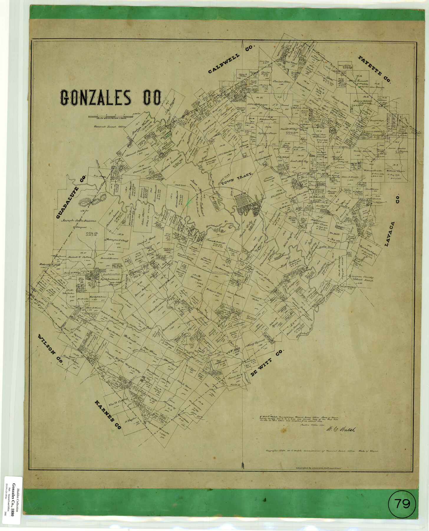
Gonzales County, Texas
-
Map/Doc
447
-
Collection
Maddox Collection
-
Object Dates
1880 (Creation Date)
1880 (Copyright Date)
-
People and Organizations
General Land Office (Publisher)
W.C. Walsh (GLO Commissioner)
August Gast & Co. (Lithographer)
-
Counties
Gonzales
-
Subjects
County
-
Height x Width
27.3 x 24.7 inches
69.3 x 62.7 cm
-
Medium
paper, etching/engraving/lithograph
-
Scale
1" = 4000 varas
-
Comments
Partially adopted in honor of Stanley Froehner by Jim and Shirley Rhoades.
Conserved in 2006 by Friends of the Texas General Land Office and Jim and Shirley Rhoades.
"Lithographed by A. Gast & Co's new process St. Louis" -
Features
San Marcos River
Clear Fork
Birds Creek
Elm Fork [of 5 Mile Creek]
Willow Creek
Clear Creek
Castleman's F[or]k [of 5 Mile Creek]
5 Mile Creek
Salt Fork [of 5 Mile Creek]
San Antonio Road
Barton Creek
Rock Creek
Guadalupe River
Mill Road
Plum Creek
Smith's Creek
Town Creek
Gonzales
Berry's Creek
Toms Branch [of Peach Creek
Smeathers Creek
Peach Creek
Denton's Creek
Bastrop Road
Mule Creek
Nash's Creek
Sandy Fork [of Peach Creek]
Part of: Maddox Collection
[Sketch of surveys in Knox County]
![555, [Sketch of surveys in Knox County], Maddox Collection](https://historictexasmaps.com/wmedia_w700/maps/555.tif.jpg)
Print $20.00
- Digital $50.00
[Sketch of surveys in Knox County]
Size 27.1 x 31.1 inches
Map/Doc 555
Hansford County, Texas

Print $20.00
- Digital $50.00
Hansford County, Texas
1888
Size 22.6 x 18.6 inches
Map/Doc 5033
[Sketch showing County School Land surveys in Throckmorton and Baylor Counties, Texas]
![75800, [Sketch showing County School Land surveys in Throckmorton and Baylor Counties, Texas], Maddox Collection](https://historictexasmaps.com/wmedia_w700/maps/75800.tif.jpg)
Print $20.00
- Digital $50.00
[Sketch showing County School Land surveys in Throckmorton and Baylor Counties, Texas]
Size 27.7 x 39.4 inches
Map/Doc 75800
Borden County, Texas

Print $20.00
- Digital $50.00
Borden County, Texas
1892
Size 25.7 x 20.9 inches
Map/Doc 394
Map of survey 189, T. C. R.R. Co. in Travis County, Texas

Print $20.00
- Digital $50.00
Map of survey 189, T. C. R.R. Co. in Travis County, Texas
1915
Size 18.6 x 15.2 inches
Map/Doc 78479
[Upton County Sketch]
![5043, [Upton County Sketch], Maddox Collection](https://historictexasmaps.com/wmedia_w700/maps/5043-1.tif.jpg)
Print $40.00
- Digital $50.00
[Upton County Sketch]
Size 19.2 x 60.3 inches
Map/Doc 5043
Palo Pinto County, Texas

Print $20.00
- Digital $50.00
Palo Pinto County, Texas
1871
Size 28.8 x 23.4 inches
Map/Doc 660
Map of Shackelford County, Texas

Print $20.00
- Digital $50.00
Map of Shackelford County, Texas
1879
Size 28.7 x 23.4 inches
Map/Doc 616
Howard County, Texas

Print $20.00
- Digital $50.00
Howard County, Texas
1870
Size 22.7 x 17.9 inches
Map/Doc 733
Plat of a portion of Buchel County, Texas

Print $20.00
- Digital $50.00
Plat of a portion of Buchel County, Texas
Size 16.0 x 26.2 inches
Map/Doc 82526
Map of surveys 191 & 192 T. C. R.R. Co. in Travis County, Texas

Print $20.00
- Digital $50.00
Map of surveys 191 & 192 T. C. R.R. Co. in Travis County, Texas
1915
Size 20.6 x 13.6 inches
Map/Doc 75554

You may also like
Trinity River, Cooks Ferry Sheet

Print $40.00
- Digital $50.00
Trinity River, Cooks Ferry Sheet
1926
Size 36.5 x 56.2 inches
Map/Doc 65215
Map of Milam County

Print $40.00
- Digital $50.00
Map of Milam County
1839
Size 54.5 x 45.9 inches
Map/Doc 3881
Travis County Working Sketch 54

Print $20.00
- Digital $50.00
Travis County Working Sketch 54
1976
Size 30.1 x 32.0 inches
Map/Doc 69438
Ward County Working Sketch 1

Print $20.00
- Digital $50.00
Ward County Working Sketch 1
1937
Size 24.7 x 24.5 inches
Map/Doc 72307
Comanche County Sketch File 11

Print $4.00
- Digital $50.00
Comanche County Sketch File 11
Size 8.6 x 15.3 inches
Map/Doc 19072
Stonewall County Sketch File 25

Print $7.00
- Digital $50.00
Stonewall County Sketch File 25
1952
Size 26.7 x 43.3 inches
Map/Doc 10375
Plot of surveys on Sims Bayou

Print $2.00
- Digital $50.00
Plot of surveys on Sims Bayou
1844
Size 6.8 x 8.3 inches
Map/Doc 26
[Plat of San Marcos, Texas]
![79312, [Plat of San Marcos, Texas], Texas State Library and Archives](https://historictexasmaps.com/wmedia_w700/maps/79312.tif.jpg)
Print $20.00
[Plat of San Marcos, Texas]
1890
Size 18.9 x 15.9 inches
Map/Doc 79312
Map of Anderson County

Print $20.00
- Digital $50.00
Map of Anderson County
1876
Size 19.4 x 21.9 inches
Map/Doc 3228
Kinney County Working Sketch 14

Print $20.00
- Digital $50.00
Kinney County Working Sketch 14
1946
Size 20.8 x 28.5 inches
Map/Doc 70196
Flight Mission No. CRC-3R, Frame 33, Chambers County

Print $20.00
- Digital $50.00
Flight Mission No. CRC-3R, Frame 33, Chambers County
1956
Size 18.6 x 22.4 inches
Map/Doc 84806
Cooke County Working Sketch 15

Print $20.00
- Digital $50.00
Cooke County Working Sketch 15
1946
Size 29.9 x 23.5 inches
Map/Doc 68252