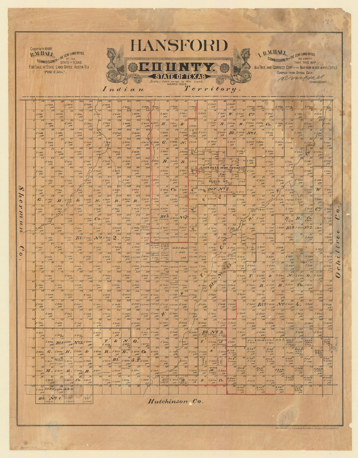
Hansford County, Texas
-
Map/Doc
5033
-
Collection
Maddox Collection
-
Object Dates
1888 (Creation Date)
1888 (Copyright Date)
-
People and Organizations
General Land Office (Publisher)
R.M. Hall (GLO Commissioner)
August Gast Bank Note & Lithograph Company (Lithographer)
-
Counties
Hansford
-
Subjects
County
-
Height x Width
22.6 x 18.6 inches
57.4 x 47.2 cm
-
Medium
paper, etching/engraving/lithograph
-
Scale
1:4000
-
Comments
Conservation funded in 2012 by Friends of the Texas General Land Office.
-
Features
Rabbits Ear Creek
Paladora Creek
Part of: Maddox Collection
Map of Grimes County, Texas

Print $20.00
- Digital $50.00
Map of Grimes County, Texas
1880
Size 29.5 x 15.6 inches
Map/Doc 432
Revised Sectional Map showing land surveys in counties of Loving and Reeves

Print $20.00
- Digital $50.00
Revised Sectional Map showing land surveys in counties of Loving and Reeves
Size 18.0 x 17.7 inches
Map/Doc 5053
Map of Brazoria Co.

Print $20.00
- Digital $50.00
Map of Brazoria Co.
1879
Size 26.5 x 26.2 inches
Map/Doc 544
Hansford County, Texas

Print $20.00
- Digital $50.00
Hansford County, Texas
1888
Size 22.6 x 18.6 inches
Map/Doc 5033
Sketch X, Hardin County

Print $20.00
- Digital $50.00
Sketch X, Hardin County
1904
Size 26.3 x 38.1 inches
Map/Doc 75823
[El Javali Grant,] Sketch of 2560 acres of land in Starr County
![474, [El Javali Grant,] Sketch of 2560 acres of land in Starr County, Maddox Collection](https://historictexasmaps.com/wmedia_w700/maps/0474-1.tif.jpg)
Print $20.00
- Digital $50.00
[El Javali Grant,] Sketch of 2560 acres of land in Starr County
Size 13.4 x 14.0 inches
Map/Doc 474
[Sketch of San Antonio del Encinal, Hidalgo County, Texas]
![4457, [Sketch of San Antonio del Encinal, Hidalgo County, Texas], Maddox Collection](https://historictexasmaps.com/wmedia_w700/maps/4457-1.tif.jpg)
Print $20.00
- Digital $50.00
[Sketch of San Antonio del Encinal, Hidalgo County, Texas]
Size 12.1 x 27.1 inches
Map/Doc 4457
[Sketch Showing L. Gonzales, Wm. H. McBee and adjacent surveys, Kaufman County, Texas]
![5071, [Sketch Showing L. Gonzales, Wm. H. McBee and adjacent surveys, Kaufman County, Texas], Maddox Collection](https://historictexasmaps.com/wmedia_w700/maps/5071.tif.jpg)
Print $20.00
- Digital $50.00
[Sketch Showing L. Gonzales, Wm. H. McBee and adjacent surveys, Kaufman County, Texas]
Size 23.2 x 19.8 inches
Map/Doc 5071
Map of Block 1, H. & G. N. R. R. Co., Dickens and Kent Counties Texas

Print $20.00
- Digital $50.00
Map of Block 1, H. & G. N. R. R. Co., Dickens and Kent Counties Texas
1908
Size 32.0 x 24.2 inches
Map/Doc 10780
Lands of Gunter & Munson and Maddox Bros. & Anderson, Tom Green Co. Tex.

Print $20.00
- Digital $50.00
Lands of Gunter & Munson and Maddox Bros. & Anderson, Tom Green Co. Tex.
Size 20.4 x 30.7 inches
Map/Doc 75787
Sketch of Menard Co.

Print $20.00
- Digital $50.00
Sketch of Menard Co.
1883
Size 15.1 x 14.2 inches
Map/Doc 536
Map of Survey in Dimmit and Webb Counties

Print $40.00
- Digital $50.00
Map of Survey in Dimmit and Webb Counties
1913
Size 31.3 x 71.0 inches
Map/Doc 75829
You may also like
Field Notes of Mercer's Colony, Robertson, Nac[a]gdoches, Fannin, & Lamar Counties.
![1953, Field Notes of Mercer's Colony, Robertson, Nac[a]gdoches, Fannin, & Lamar Counties., General Map Collection](https://historictexasmaps.com/wmedia_w700/pdf_converted_jpg/qi_pdf_thumbnail_897.jpg)
Print $30.00
- Digital $50.00
Field Notes of Mercer's Colony, Robertson, Nac[a]gdoches, Fannin, & Lamar Counties.
1845
Size 9.5 x 14.8 inches
Map/Doc 1953
[I. Killough and Hiram Cates surveys and vicinity]
![91851, [I. Killough and Hiram Cates surveys and vicinity], Twichell Survey Records](https://historictexasmaps.com/wmedia_w700/maps/91851-1.tif.jpg)
Print $20.00
- Digital $50.00
[I. Killough and Hiram Cates surveys and vicinity]
Size 27.5 x 9.2 inches
Map/Doc 91851
Cameron County Aerial Photograph Index Sheet 5

Print $20.00
- Digital $50.00
Cameron County Aerial Photograph Index Sheet 5
1940
Size 20.4 x 24.3 inches
Map/Doc 83681
General Highway Map, Howard County, Texas

Print $20.00
General Highway Map, Howard County, Texas
1940
Size 18.5 x 24.7 inches
Map/Doc 79134
Trinity River, Trinidad Sheet

Print $20.00
- Digital $50.00
Trinity River, Trinidad Sheet
1928
Size 39.0 x 46.3 inches
Map/Doc 65183
Runnels County Boundary File 2

Print $36.00
- Digital $50.00
Runnels County Boundary File 2
Size 14.4 x 8.8 inches
Map/Doc 58517
La Salle County Sketch File 24

Print $4.00
- Digital $50.00
La Salle County Sketch File 24
1877
Size 9.2 x 6.1 inches
Map/Doc 29547
Kimble County Sketch File 35

Print $16.00
- Digital $50.00
Kimble County Sketch File 35
1963
Size 11.2 x 8.7 inches
Map/Doc 28982
Calhoun County Working Sketch 2a

Print $20.00
- Digital $50.00
Calhoun County Working Sketch 2a
1913
Size 17.4 x 20.1 inches
Map/Doc 67817
Crockett County Sketch File H

Print $26.00
- Digital $50.00
Crockett County Sketch File H
1920
Size 14.4 x 9.0 inches
Map/Doc 19638
Map of Nacogdoches County

Print $20.00
- Digital $50.00
Map of Nacogdoches County
1881
Size 23.7 x 21.0 inches
Map/Doc 4599
Medina County Working Sketch 21

Print $20.00
- Digital $50.00
Medina County Working Sketch 21
1982
Size 18.1 x 23.3 inches
Map/Doc 70936