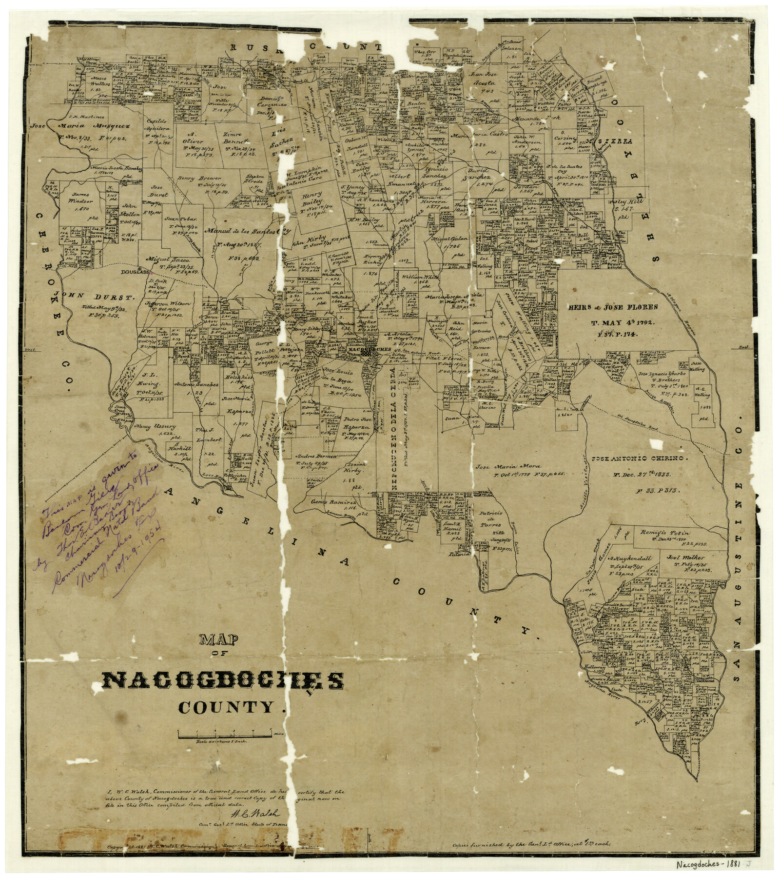
Map of Nacogdoches County
-
Map/Doc
4599
-
Collection
General Map Collection
-
Object Dates
1881 (Creation Date)
-
People and Organizations
Texas General Land Office (Publisher)
W.C. Walsh (GLO Commissioner)
G.N. Beaumont (Draftsman)
G.N. Beaumont (Compiler)
August Gast & Co. (Lithographer)
-
Counties
Nacogdoches
-
Subjects
County
-
Height x Width
23.7 x 21.0 inches
60.2 x 53.3 cm
-
Comments
Copyrighted 1881.
Note on map: "This map is given to Bascom Giles, Com. Gen. Land Office by Thos. E. Baker, Chairman Board, Commercial Nat'l Bank, Nacogdoches Tex. 10-29-1954". -
Features
Lamana Bayou
Bayou Carizo
Arroya Amaladero
Old Nacogdoches Road
Agillitas Creek
Melrose
Bayou Morell
Alazon Bayou
Little Loco Creek
Angelina River
Douglass
Dorr Creek
Patonia
Arrollo Visitador
Durazno Bayou
La Vaca Creek
Sandy Creek
Nacogdoches
Loco Bayou
Cany Creek
Pen Creek
Beeck Creek
Colondrina Bayou
Wandes Bayou
Aycilas Crossing
Naconiche Bayou
Arroya Nasosote
Raiz Creek
Bills Creek
Attoyac Bayou
Shelbyville Road
White Oak Creek
Old San Antonio Road
Red Creek
Bolija Creek
Rota Creek
Loco Creek
Part of: General Map Collection
Jim Hogg County Rolled Sketch 7

Print $20.00
- Digital $50.00
Jim Hogg County Rolled Sketch 7
1948
Size 32.5 x 28.2 inches
Map/Doc 6442
The Latest Map of Texas

Print $20.00
- Digital $50.00
The Latest Map of Texas
1889
Size 32.0 x 34.0 inches
Map/Doc 93422

Leon County Rolled Sketch 11

Print $20.00
- Digital $50.00
Leon County Rolled Sketch 11
1965
Size 16.8 x 19.7 inches
Map/Doc 6599
Brazoria County Rolled Sketch 28

Print $40.00
- Digital $50.00
Brazoria County Rolled Sketch 28
Size 35.7 x 56.8 inches
Map/Doc 8458

Crockett County Sketch File 15

Print $24.00
- Digital $50.00
Crockett County Sketch File 15
1880
Size 9.1 x 8.0 inches
Map/Doc 19666
Flight Mission No. BQR-13K, Frame 26, Brazoria County

Print $20.00
- Digital $50.00
Flight Mission No. BQR-13K, Frame 26, Brazoria County
1952
Size 18.7 x 22.4 inches
Map/Doc 84074
Flight Mission No. DAG-28K, Frame 30, Matagorda County

Print $20.00
- Digital $50.00
Flight Mission No. DAG-28K, Frame 30, Matagorda County
1953
Size 16.1 x 16.1 inches
Map/Doc 86598
Comanche County Sketch File 22b

Print $40.00
- Digital $50.00
Comanche County Sketch File 22b
1872
Size 12.1 x 14.8 inches
Map/Doc 19109
Edwards County Working Sketch 128

Print $20.00
- Digital $50.00
Edwards County Working Sketch 128
1981
Size 26.5 x 32.4 inches
Map/Doc 69004
Presidio County Sketch File 72

Print $6.00
- Digital $50.00
Presidio County Sketch File 72
1943
Size 13.3 x 8.8 inches
Map/Doc 34679
You may also like
Farm Owned by Dr. J. T. Krueger

Print $20.00
- Digital $50.00
Farm Owned by Dr. J. T. Krueger
Size 16.9 x 32.8 inches
Map/Doc 92344
Real County Sketch File 8

Print $20.00
- Digital $50.00
Real County Sketch File 8
1931
Size 19.5 x 21.6 inches
Map/Doc 12230

Flight Mission No. CRC-4R, Frame 163, Chambers County

Print $20.00
- Digital $50.00
Flight Mission No. CRC-4R, Frame 163, Chambers County
1956
Size 18.5 x 22.4 inches
Map/Doc 84922
[Blocks T2 and T3]
![90992, [Blocks T2 and T3], Twichell Survey Records](https://historictexasmaps.com/wmedia_w700/maps/90992-1.tif.jpg)
Print $20.00
- Digital $50.00
[Blocks T2 and T3]
Size 12.2 x 14.6 inches
Map/Doc 90992
Flight Mission No. DQO-13T, Frame 48, Galveston County

Print $20.00
- Digital $50.00
Flight Mission No. DQO-13T, Frame 48, Galveston County
1958
Size 18.5 x 18.2 inches
Map/Doc 85212
Erath County Sketch File 8

Print $4.00
- Digital $50.00
Erath County Sketch File 8
Size 8.6 x 13.0 inches
Map/Doc 22269
Map of the City of Dallas, Texas, compiled from the records of Dallas Co., and latest surveys of the City Engineer

Map of the City of Dallas, Texas, compiled from the records of Dallas Co., and latest surveys of the City Engineer
1878
Size 22.9 x 31.1 inches
Map/Doc 76174
Edwards County Working Sketch 62

Print $20.00
- Digital $50.00
Edwards County Working Sketch 62
1955
Size 21.7 x 28.5 inches
Map/Doc 68938
[Sketch for Mineral Application 26501 - Sabine River, T. A. Oldhausen]
![2832, [Sketch for Mineral Application 26501 - Sabine River, T. A. Oldhausen], General Map Collection](https://historictexasmaps.com/wmedia_w700/maps/2832.tif.jpg)
Print $20.00
- Digital $50.00
[Sketch for Mineral Application 26501 - Sabine River, T. A. Oldhausen]
1931
Size 24.0 x 36.0 inches
Map/Doc 2832
Regni Mexicani seu Novae Hispaniae, Ludovicianae, N. Angliae, Carolinae, Virginiae, et Pennsylvaniae

Print $20.00
- Digital $50.00
Regni Mexicani seu Novae Hispaniae, Ludovicianae, N. Angliae, Carolinae, Virginiae, et Pennsylvaniae
1720
Size 22.5 x 26.5 inches
Map/Doc 93408
San Jacinto County Working Sketch 35

Print $20.00
- Digital $50.00
San Jacinto County Working Sketch 35
1955
Size 31.3 x 32.1 inches
Map/Doc 63748