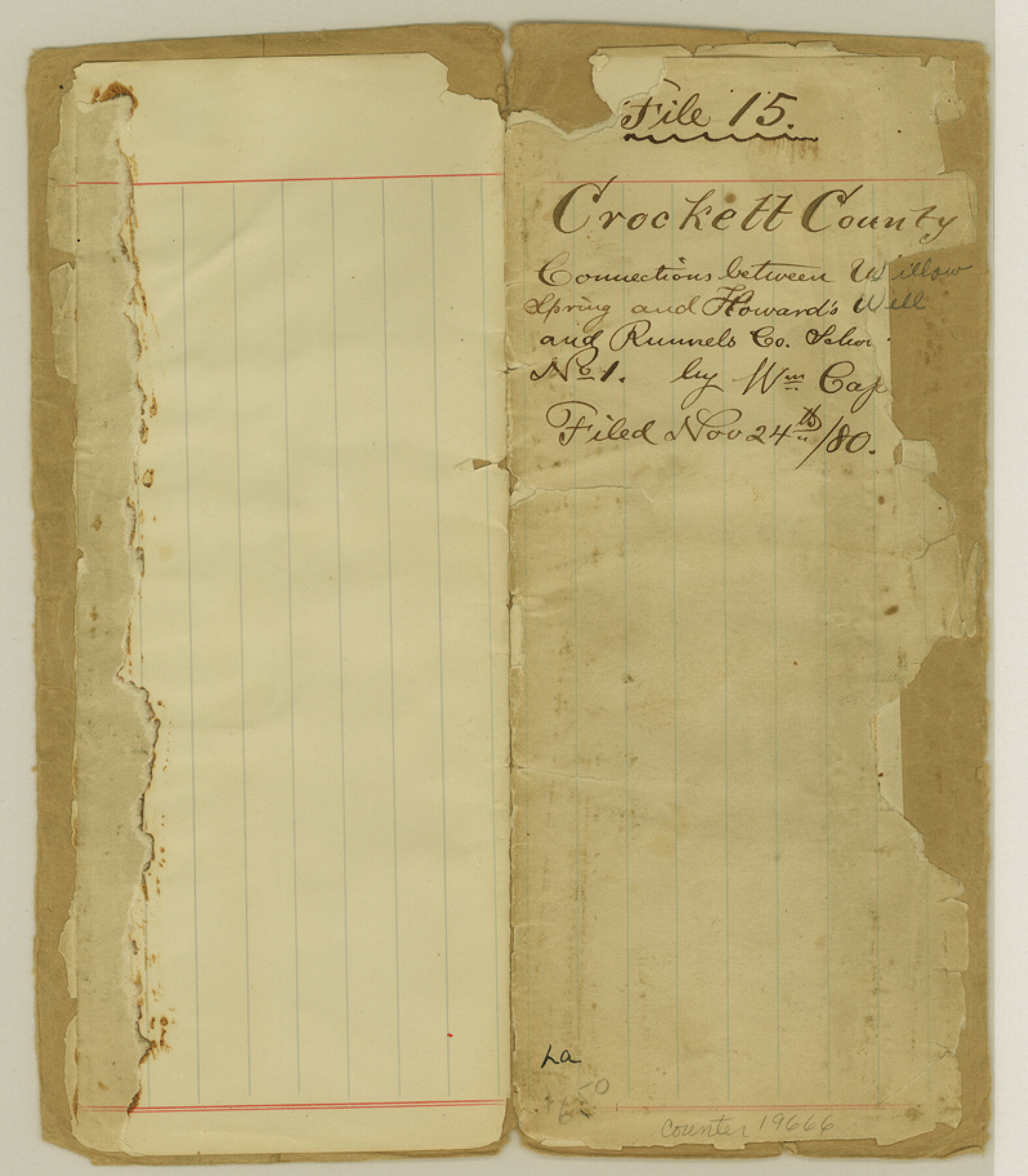
Crockett County Sketch File 15
[Connections between Willow Spring and Howard's Well and Runnels County Labor No. 1]
-
Map/Doc
19666
-
Collection
General Map Collection
-
Object Dates
1880/8/14 (Creation Date)
1880/11/24 (File Date)
-
People and Organizations
Wm. Cassin (Surveyor/Engineer)
George Blythe (Chainman)
Will Palm (Chainman)
Will John (Chainman)
-
Counties
Crockett
-
Subjects
Surveying Sketch File
-
Height x Width
9.1 x 8.0 inches
23.1 x 20.3 cm
-
Medium
paper, manuscript
-
Features
Willow Springs
Howard's Well
Beaver Lake
Johnsons Rim
Dove Creek
Devils River
Fort Lancaster
Howard's Creek
El Paso and San Antonio Wagon Road
El Paso Wagon Road
San Antonio Wagon Road
Part of: General Map Collection
Real County Working Sketch 50

Print $20.00
- Digital $50.00
Real County Working Sketch 50
1957
Size 19.8 x 26.1 inches
Map/Doc 71942
Current Miscellaneous File 41

Print $8.00
- Digital $50.00
Current Miscellaneous File 41
Size 8.2 x 10.8 inches
Map/Doc 73977
La Salle County Sketch File 38

Print $40.00
- Digital $50.00
La Salle County Sketch File 38
Size 13.7 x 14.5 inches
Map/Doc 29590
Kimble County Sketch File 8

Print $14.00
- Digital $50.00
Kimble County Sketch File 8
1847
Size 7.7 x 7.0 inches
Map/Doc 28920
Fisher County Working Sketch 7

Print $20.00
- Digital $50.00
Fisher County Working Sketch 7
1944
Size 36.7 x 28.9 inches
Map/Doc 69141
Comanche County Boundary File 2c

Print $8.00
- Digital $50.00
Comanche County Boundary File 2c
Size 14.3 x 8.9 inches
Map/Doc 51796
Flight Mission No. DAG-17K, Frame 122, Matagorda County

Print $20.00
- Digital $50.00
Flight Mission No. DAG-17K, Frame 122, Matagorda County
1952
Size 16.5 x 16.4 inches
Map/Doc 86342
Hardin County Sketch File 28

Print $4.00
- Digital $50.00
Hardin County Sketch File 28
Size 5.9 x 5.8 inches
Map/Doc 25153
South Part Brewster Co.

Print $40.00
- Digital $50.00
South Part Brewster Co.
Size 35.2 x 49.8 inches
Map/Doc 66724
Culberson County Working Sketch 4

Print $20.00
- Digital $50.00
Culberson County Working Sketch 4
Size 37.7 x 32.2 inches
Map/Doc 68456
Galveston County Sketch File 33

Print $12.00
- Digital $50.00
Galveston County Sketch File 33
1934
Size 11.2 x 8.8 inches
Map/Doc 23413
Hunt County Sketch File 38

Print $6.00
- Digital $50.00
Hunt County Sketch File 38
Size 11.0 x 10.8 inches
Map/Doc 27157
You may also like
Galveston County Rolled Sketch 21

Print $41.00
- Digital $50.00
Galveston County Rolled Sketch 21
Size 10.5 x 15.1 inches
Map/Doc 45061
Anderson County Working Sketch 41

Print $20.00
- Digital $50.00
Anderson County Working Sketch 41
1956
Size 19.2 x 20.5 inches
Map/Doc 67041
Milam County Boundary File 4

Print $4.00
- Digital $50.00
Milam County Boundary File 4
Size 13.3 x 8.2 inches
Map/Doc 57221
Galveston Harbor, Texas - U.S. Harbor Lines - Galveston Harbor, Galveston Channel, Channel from Galveston Harbor to Texas City and Channel to Port Bolivar

Print $20.00
- Digital $50.00
Galveston Harbor, Texas - U.S. Harbor Lines - Galveston Harbor, Galveston Channel, Channel from Galveston Harbor to Texas City and Channel to Port Bolivar
1939
Size 39.4 x 26.7 inches
Map/Doc 73631
Canada, United States of America, Estados Unidos Mexicanos

Print $20.00
- Digital $50.00
Canada, United States of America, Estados Unidos Mexicanos
Size 41.9 x 36.1 inches
Map/Doc 96512
Donley County

Print $20.00
- Digital $50.00
Donley County
1944
Size 43.6 x 37.7 inches
Map/Doc 77266
San Jacinto County Rolled Sketch 12

Print $20.00
- Digital $50.00
San Jacinto County Rolled Sketch 12
1948
Size 24.2 x 32.5 inches
Map/Doc 7561

Beaumont, Texas

Print $20.00
- Digital $50.00
Beaumont, Texas
1930
Size 10.3 x 32.7 inches
Map/Doc 96428
Travis County Sketch File 19-28

Print $12.00
- Digital $50.00
Travis County Sketch File 19-28
1873
Size 8.6 x 7.7 inches
Map/Doc 38317
[Sketch of surveys in the vicinity of sections 171 and 172 along Pedernales]
![91880, [Sketch of surveys in the vicinity of sections 171 and 172 along Pedernales], Twichell Survey Records](https://historictexasmaps.com/wmedia_w700/maps/91880-1.tif.jpg)
Print $20.00
- Digital $50.00
[Sketch of surveys in the vicinity of sections 171 and 172 along Pedernales]
Size 15.8 x 14.3 inches
Map/Doc 91880
Hudspeth county Sketch File 12a

Print $20.00
- Digital $50.00
Hudspeth county Sketch File 12a
1894
Size 13.3 x 34.7 inches
Map/Doc 11800