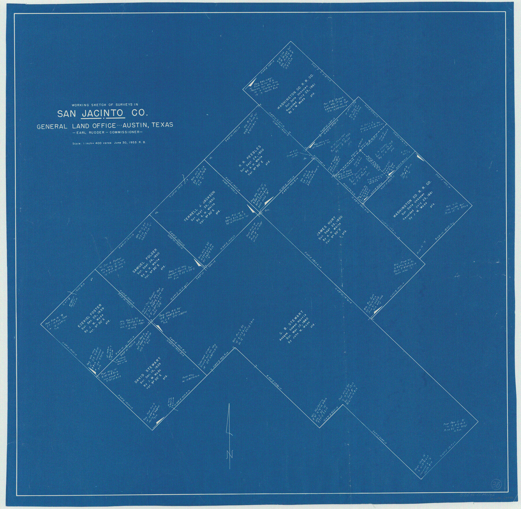
San Jacinto County Working Sketch 35
-
Map/Doc
63748
-
Collection
General Map Collection
-
Object Dates
6/30/1955 (Creation Date)
-
People and Organizations
Roy Buckholts (Draftsman)
-
Counties
San Jacinto
-
Subjects
Surveying Working Sketch
-
Height x Width
31.3 x 32.1 inches
79.5 x 81.5 cm
-
Scale
1" = 400 varas
Part of: General Map Collection
Dawson County Sketch File 13

Print $2.00
- Digital $50.00
Dawson County Sketch File 13
Size 11.2 x 8.6 inches
Map/Doc 20546
Archer County Working Sketch 25

Print $20.00
- Digital $50.00
Archer County Working Sketch 25
Size 24.9 x 33.1 inches
Map/Doc 78188
El Paso County Rolled Sketch 19

Print $101.00
- Digital $50.00
El Paso County Rolled Sketch 19
1886
Size 16.7 x 26.5 inches
Map/Doc 5823
Cass County Working Sketch 35

Print $20.00
- Digital $50.00
Cass County Working Sketch 35
1982
Size 23.5 x 44.8 inches
Map/Doc 67938
Railroad Track Map, H&TCRRCo., Falls County, Texas

Print $4.00
- Digital $50.00
Railroad Track Map, H&TCRRCo., Falls County, Texas
1918
Size 11.7 x 18.5 inches
Map/Doc 62831
[Sabine Pass]
![78263, [Sabine Pass], General Map Collection](https://historictexasmaps.com/wmedia_w700/maps/78263.tif.jpg)
Print $20.00
- Digital $50.00
[Sabine Pass]
1916
Size 29.2 x 42.1 inches
Map/Doc 78263
Presidio County Rolled Sketch 133

Print $20.00
- Digital $50.00
Presidio County Rolled Sketch 133
Size 37.3 x 27.2 inches
Map/Doc 7400
Chambers County Working Sketch 5

Print $20.00
- Digital $50.00
Chambers County Working Sketch 5
1938
Size 20.9 x 31.6 inches
Map/Doc 67988
Edwards County Sketch File 24

Print $6.00
- Digital $50.00
Edwards County Sketch File 24
Size 8.9 x 13.2 inches
Map/Doc 21751
Corpus Christi Pass, Texas

Print $3.00
- Digital $50.00
Corpus Christi Pass, Texas
1869
Size 16.7 x 11.2 inches
Map/Doc 73456
Flight Mission No. BQR-22K, Frame 37, Brazoria County

Print $20.00
- Digital $50.00
Flight Mission No. BQR-22K, Frame 37, Brazoria County
1953
Size 18.8 x 22.4 inches
Map/Doc 84121
Post Route Map of the State of Texas with adjacent parts of Louisiana, Arkansas, Indian Territory, and of the Republic of Mexico showing post offices with the intermediate and mail routes in operation on the 1st of December, 1892

Print $40.00
- Digital $50.00
Post Route Map of the State of Texas with adjacent parts of Louisiana, Arkansas, Indian Territory, and of the Republic of Mexico showing post offices with the intermediate and mail routes in operation on the 1st of December, 1892
1889
Size 44.0 x 57.3 inches
Map/Doc 94080
You may also like
Official Copy of the Map of Williamson County made for the International and G. N. R. R. Co.

Print $20.00
- Digital $50.00
Official Copy of the Map of Williamson County made for the International and G. N. R. R. Co.
1877
Size 23.3 x 28.4 inches
Map/Doc 672
[Blocks Surrounding Block T]
![92891, [Blocks Surrounding Block T], Twichell Survey Records](https://historictexasmaps.com/wmedia_w700/maps/92891-1.tif.jpg)
Print $20.00
- Digital $50.00
[Blocks Surrounding Block T]
Size 20.8 x 24.3 inches
Map/Doc 92891
Seagraves Cemetery, Gaines County, Texas

Print $20.00
- Digital $50.00
Seagraves Cemetery, Gaines County, Texas
Size 23.2 x 19.2 inches
Map/Doc 92685
Brown County Sketch File 13

Print $40.00
- Digital $50.00
Brown County Sketch File 13
Size 17.9 x 33.1 inches
Map/Doc 11020
Map of Uvalde Co.

Print $20.00
- Digital $50.00
Map of Uvalde Co.
1893
Size 42.7 x 42.5 inches
Map/Doc 16911
Parker County Sketch File 50

Print $68.00
- Digital $50.00
Parker County Sketch File 50
2022
Size 11.0 x 8.5 inches
Map/Doc 96679
Hood County Working Sketch 1

Print $20.00
- Digital $50.00
Hood County Working Sketch 1
1934
Size 18.2 x 24.5 inches
Map/Doc 66195
Plat of All Surveys on the Lavaca Not Heretofor Returned

Print $2.00
- Digital $50.00
Plat of All Surveys on the Lavaca Not Heretofor Returned
1841
Size 12.5 x 7.8 inches
Map/Doc 78361
Grimes County Working Sketch 17

Print $20.00
- Digital $50.00
Grimes County Working Sketch 17
1996
Size 31.1 x 26.6 inches
Map/Doc 63308
La Salle County Working Sketch 34

Print $20.00
- Digital $50.00
La Salle County Working Sketch 34
1956
Size 18.8 x 26.2 inches
Map/Doc 70335
Flight Mission No. CRK-7P, Frame 133, Refugio County

Print $20.00
- Digital $50.00
Flight Mission No. CRK-7P, Frame 133, Refugio County
1956
Size 18.3 x 22.1 inches
Map/Doc 86956
Travis County Sketch File 65

Print $4.00
- Digital $50.00
Travis County Sketch File 65
1948
Size 9.1 x 9.1 inches
Map/Doc 38438