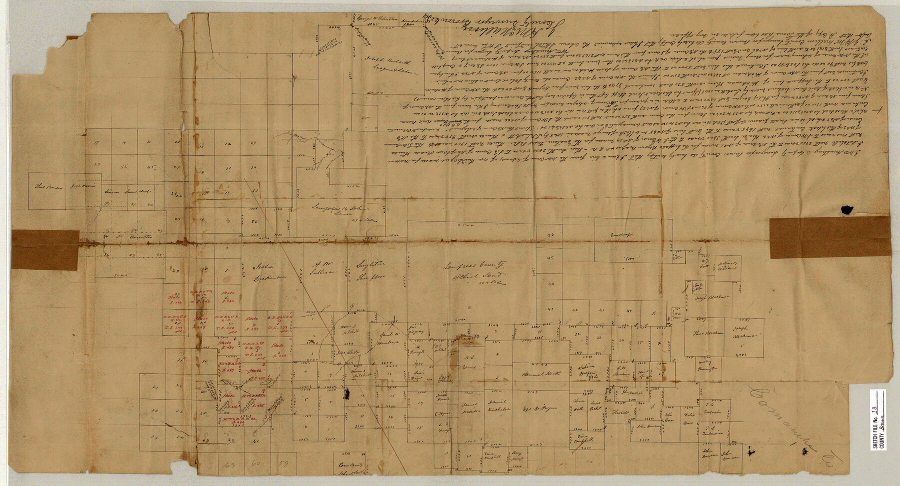
Brown County Sketch File 13
[Sketch and statement relating to surveys in the northeast part of Brown County the southwest part of Comanche County]
-
Map/Doc
11020
-
Collection
General Map Collection
-
Object Dates
1870/11/1 (File Date)
-
People and Organizations
Wm. Armstrong (Surveyor/Engineer)
-
Counties
Comanche Brown
-
Subjects
Surveying Sketch File
-
Height x Width
17.9 x 33.1 inches
45.5 x 84.1 cm
-
Medium
paper, manuscript
Part of: General Map Collection
Galveston County Rolled Sketch 28

Print $347.00
- Digital $50.00
Galveston County Rolled Sketch 28
Size 22.6 x 18.1 inches
Map/Doc 6068
Chart of soundings through the different channels in Aransas and Matagorda Bays as taken in 1855 by Capt. R. B. Marey, U. S. A. [Inset: Harbour of Lamar and Live-Oak Pt.]
![72978, Chart of soundings through the different channels in Aransas and Matagorda Bays as taken in 1855 by Capt. R. B. Marey, U. S. A. [Inset: Harbour of Lamar and Live-Oak Pt.], General Map Collection](https://historictexasmaps.com/wmedia_w700/maps/72978.tif.jpg)
Print $20.00
- Digital $50.00
Chart of soundings through the different channels in Aransas and Matagorda Bays as taken in 1855 by Capt. R. B. Marey, U. S. A. [Inset: Harbour of Lamar and Live-Oak Pt.]
Size 28.4 x 18.3 inches
Map/Doc 72978
Gregg County Working Sketch 20

Print $20.00
- Digital $50.00
Gregg County Working Sketch 20
1962
Size 34.3 x 44.4 inches
Map/Doc 63287

Township 8 North Range 14 West, North Western District, Louisiana

Print $20.00
- Digital $50.00
Township 8 North Range 14 West, North Western District, Louisiana
1854
Size 19.7 x 24.7 inches
Map/Doc 65874
Smith County Rolled Sketch 6A3

Print $40.00
- Digital $50.00
Smith County Rolled Sketch 6A3
1990
Size 48.6 x 36.8 inches
Map/Doc 10698
Brewster County Sketch File N-3

Print $6.00
- Digital $50.00
Brewster County Sketch File N-3
1882
Size 8.6 x 7.6 inches
Map/Doc 15589
Kleberg County Aerial Photograph Index Sheet 5

Print $20.00
- Digital $50.00
Kleberg County Aerial Photograph Index Sheet 5
1956
Size 19.5 x 23.5 inches
Map/Doc 83722

Trinity River, Levee Improvement Districts, Widths of Floodways

Print $4.00
- Digital $50.00
Trinity River, Levee Improvement Districts, Widths of Floodways
1919
Size 23.5 x 17.6 inches
Map/Doc 65250
Kerr County Working Sketch 24

Print $20.00
- Digital $50.00
Kerr County Working Sketch 24
1966
Size 35.9 x 38.3 inches
Map/Doc 70055
Harris County Working Sketch 79

Print $20.00
- Digital $50.00
Harris County Working Sketch 79
1968
Size 22.4 x 22.9 inches
Map/Doc 65971
You may also like
Wichita County Working Sketch 11

Print $20.00
- Digital $50.00
Wichita County Working Sketch 11
1920
Size 32.0 x 18.8 inches
Map/Doc 72520
[Sketch for Mineral Application 26501 - Sabine River, T. A. Oldhausen]
![2839, [Sketch for Mineral Application 26501 - Sabine River, T. A. Oldhausen], General Map Collection](https://historictexasmaps.com/wmedia_w700/maps/2839.tif.jpg)
Print $20.00
- Digital $50.00
[Sketch for Mineral Application 26501 - Sabine River, T. A. Oldhausen]
1931
Size 17.7 x 36.4 inches
Map/Doc 2839
Lubbock County Boundary File 5

Print $2.00
- Digital $50.00
Lubbock County Boundary File 5
Size 7.2 x 8.2 inches
Map/Doc 56493
Louisiana and Texas Intracoastal Waterway, Section 7, Galveston Bay to Brazos River and Section 8, Brazos River to Matagorda Bay

Print $20.00
- Digital $50.00
Louisiana and Texas Intracoastal Waterway, Section 7, Galveston Bay to Brazos River and Section 8, Brazos River to Matagorda Bay
1937
Size 30.7 x 42.7 inches
Map/Doc 73064
Young County Rolled Sketch 19

Print $20.00
- Digital $50.00
Young County Rolled Sketch 19
2021
Size 24.3 x 30.4 inches
Map/Doc 97023
[Liberty County, Texas]
![2058, [Liberty County, Texas], General Map Collection](https://historictexasmaps.com/wmedia_w700/maps/2058-1.tif.jpg)
Print $20.00
- Digital $50.00
[Liberty County, Texas]
1890
Size 23.7 x 18.3 inches
Map/Doc 2058
Crane County Working Sketch 7

Print $20.00
- Digital $50.00
Crane County Working Sketch 7
1929
Size 33.6 x 23.2 inches
Map/Doc 68284
Carta de las provincias de Tejas Nuevo Santander, Nuevo Reino de Leon y Nueva Estremadura

Print $20.00
- Digital $50.00
Carta de las provincias de Tejas Nuevo Santander, Nuevo Reino de Leon y Nueva Estremadura
1773
Size 21.5 x 26.6 inches
Map/Doc 3031
PSL Field Notes for Block CS in Dallam County

PSL Field Notes for Block CS in Dallam County
Map/Doc 81649
Working Sketch in Hale County

Print $3.00
- Digital $50.00
Working Sketch in Hale County
Size 16.4 x 11.8 inches
Map/Doc 90746
Bastrop County Rolled Sketch 1

Print $20.00
- Digital $50.00
Bastrop County Rolled Sketch 1
Size 30.0 x 23.9 inches
Map/Doc 5121
Duval County Rolled Sketch 48

Print $20.00
- Digital $50.00
Duval County Rolled Sketch 48
Size 21.8 x 18.5 inches
Map/Doc 5762