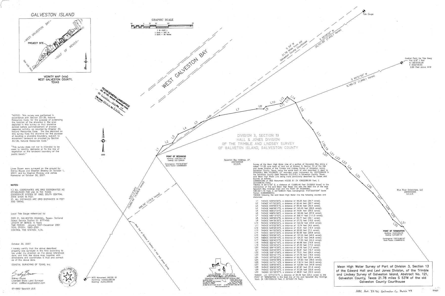
Galveston County NRC Article 33.136 Sketch 49
Mean high water survey of part of division 3, section 13 of the Edward Hall and Levi Jones division of the Trimble and Lindsey survey of Galveston Island, abstract no. 121
-
Map/Doc
94663
-
Collection
General Map Collection
-
Object Dates
2007/10/30 (Creation Date)
2018/6/22 (File Date)
-
People and Organizations
Sidney Bouse (Surveyor/Engineer)
-
Counties
Galveston
-
Subjects
Surveying CBS
-
Height x Width
24.0 x 36.0 inches
61.0 x 91.4 cm
-
Medium
multi-page, multi-format
Part of: General Map Collection
Live Oak County Working Sketch 26

Print $20.00
- Digital $50.00
Live Oak County Working Sketch 26
1980
Size 13.9 x 16.9 inches
Map/Doc 70611
East Part of Anderson County

Print $40.00
- Digital $50.00
East Part of Anderson County
1942
Size 52.0 x 42.3 inches
Map/Doc 77198
Calhoun County Sketch File 20

Print $10.00
Calhoun County Sketch File 20
1839
Size 8.8 x 8.6 inches
Map/Doc 76865
Brewster County Working Sketch 91

Print $40.00
- Digital $50.00
Brewster County Working Sketch 91
1975
Size 65.7 x 43.6 inches
Map/Doc 67691
Coleman County Working Sketch 3

Print $20.00
- Digital $50.00
Coleman County Working Sketch 3
1918
Size 27.1 x 29.2 inches
Map/Doc 68069
Hardin County Sketch File X

Print $9.00
- Digital $50.00
Hardin County Sketch File X
Size 8.2 x 8.3 inches
Map/Doc 25075
Webb County Rolled Sketch 33

Print $20.00
- Digital $50.00
Webb County Rolled Sketch 33
1939
Size 22.8 x 23.9 inches
Map/Doc 8189
Baylor County Sketch File Z3

Print $8.00
- Digital $50.00
Baylor County Sketch File Z3
1908
Size 12.9 x 8.3 inches
Map/Doc 14110
Flight Mission No. CRK-8P, Frame 117, Refugio County

Print $20.00
- Digital $50.00
Flight Mission No. CRK-8P, Frame 117, Refugio County
1956
Size 18.1 x 22.0 inches
Map/Doc 86972
Harris County Rolled Sketch 83

Print $20.00
- Digital $50.00
Harris County Rolled Sketch 83
1958
Size 28.2 x 45.6 inches
Map/Doc 9139
Lavaca County Working Sketch 6

Print $20.00
- Digital $50.00
Lavaca County Working Sketch 6
1941
Size 20.8 x 22.0 inches
Map/Doc 70359
Galveston County NRC Article 33.136 Sketch 57

Print $44.00
- Digital $50.00
Galveston County NRC Article 33.136 Sketch 57
2009
Size 22.0 x 34.0 inches
Map/Doc 94736
You may also like
Val Verde County Working Sketch 77

Print $20.00
- Digital $50.00
Val Verde County Working Sketch 77
1972
Size 45.9 x 38.5 inches
Map/Doc 72212
Tom Green County Sketch File 5

Print $42.00
- Digital $50.00
Tom Green County Sketch File 5
1849
Size 8.5 x 7.1 inches
Map/Doc 38167

Pecos County Sketch File 29

Print $20.00
- Digital $50.00
Pecos County Sketch File 29
1929
Size 26.1 x 15.8 inches
Map/Doc 12170
Polk County Working Sketch 14

Print $20.00
- Digital $50.00
Polk County Working Sketch 14
1945
Size 32.3 x 37.7 inches
Map/Doc 71629
[Panhandle Counties]
![89951, [Panhandle Counties], Twichell Survey Records](https://historictexasmaps.com/wmedia_w700/maps/89951-1.tif.jpg)
Print $20.00
- Digital $50.00
[Panhandle Counties]
Size 41.8 x 43.2 inches
Map/Doc 89951
Callahan County Working Sketch 7

Print $20.00
- Digital $50.00
Callahan County Working Sketch 7
1955
Size 25.1 x 12.7 inches
Map/Doc 67889
Little River, Buckholts Sheet

Print $4.00
- Digital $50.00
Little River, Buckholts Sheet
1936
Size 30.0 x 24.2 inches
Map/Doc 65065

Texas, Corpus Christi Bay, Mustang Island

Print $40.00
- Digital $50.00
Texas, Corpus Christi Bay, Mustang Island
1934
Size 49.6 x 35.0 inches
Map/Doc 73462
Erath County Rolled Sketch 3

Print $20.00
- Digital $50.00
Erath County Rolled Sketch 3
1982
Size 22.6 x 27.9 inches
Map/Doc 5864
Flight Mission No. DQO-8K, Frame 143, Galveston County

Print $20.00
- Digital $50.00
Flight Mission No. DQO-8K, Frame 143, Galveston County
1952
Size 18.6 x 22.5 inches
Map/Doc 85205