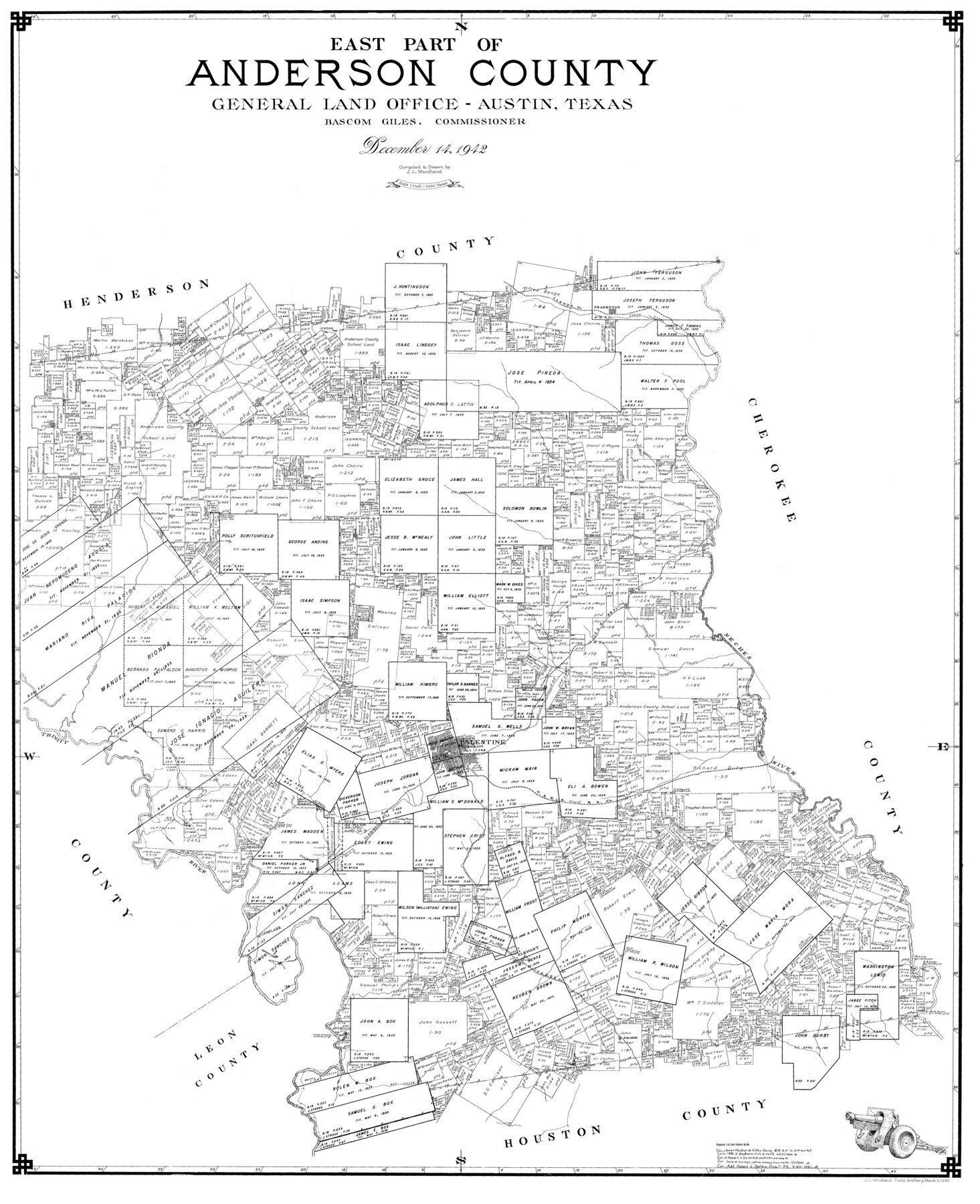
East Part of Anderson County
-
Map/Doc
77198
-
Collection
General Map Collection
-
Object Dates
1942/12/14 (Creation Date)
-
Counties
Anderson
-
Subjects
County
-
Height x Width
52.0 x 42.3 inches
132.1 x 107.4 cm
Part of: General Map Collection
Flight Mission No. DAG-14K, Frame 134, Matagorda County

Print $20.00
- Digital $50.00
Flight Mission No. DAG-14K, Frame 134, Matagorda County
1952
Size 17.6 x 17.4 inches
Map/Doc 86305
Orange County Working Sketch 17

Print $20.00
- Digital $50.00
Orange County Working Sketch 17
1930
Size 35.6 x 26.1 inches
Map/Doc 71349
Kendall County Working Sketch 16

Print $20.00
- Digital $50.00
Kendall County Working Sketch 16
1967
Size 28.0 x 29.1 inches
Map/Doc 66688

Throckmorton County Working Sketch 12

Print $20.00
- Digital $50.00
Throckmorton County Working Sketch 12
2019
Size 24.7 x 36.7 inches
Map/Doc 95719
Lynn County Boundary File 10

Print $110.00
- Digital $50.00
Lynn County Boundary File 10
Size 14.3 x 8.7 inches
Map/Doc 56709
Crockett County Sketch File 99

Print $14.00
- Digital $50.00
Crockett County Sketch File 99
1925
Size 14.4 x 9.4 inches
Map/Doc 19980
Jackson County

Print $20.00
- Digital $50.00
Jackson County
1896
Size 24.8 x 21.0 inches
Map/Doc 3710
Map of Harrison County

Print $20.00
- Digital $50.00
Map of Harrison County
1880
Size 20.4 x 21.8 inches
Map/Doc 1119
Map of a part of Laguna Madre showing subdivision for mineral development

Print $20.00
- Digital $50.00
Map of a part of Laguna Madre showing subdivision for mineral development
1948
Size 37.4 x 27.7 inches
Map/Doc 2914
Sutton County Working Sketch 66

Print $20.00
- Digital $50.00
Sutton County Working Sketch 66
1972
Size 29.0 x 39.3 inches
Map/Doc 62409
Crockett County Sketch File 65

Print $20.00
- Digital $50.00
Crockett County Sketch File 65
1927
Size 23.2 x 36.6 inches
Map/Doc 11230
You may also like
Travis County Appraisal District Plat Map 2_2105

Print $20.00
- Digital $50.00
Travis County Appraisal District Plat Map 2_2105
Size 21.6 x 26.5 inches
Map/Doc 94200
Cottle County Working Sketch 10

Print $20.00
- Digital $50.00
Cottle County Working Sketch 10
1937
Size 18.1 x 15.6 inches
Map/Doc 68320

Johnson County Working Sketch 2

Print $20.00
- Digital $50.00
Johnson County Working Sketch 2
Size 20.8 x 20.2 inches
Map/Doc 66615
Right of Way & Track Map, The Texas & Pacific Ry. Co. Main Line

Print $20.00
- Digital $50.00
Right of Way & Track Map, The Texas & Pacific Ry. Co. Main Line
Size 11.0 x 18.3 inches
Map/Doc 64687
Taylor County Rolled Sketch 25

Print $20.00
- Digital $50.00
Taylor County Rolled Sketch 25
1962
Size 27.1 x 46.0 inches
Map/Doc 7917
[Strip Map showing T. & P. connecting lines]
![93182, [Strip Map showing T. & P. connecting lines], Twichell Survey Records](https://historictexasmaps.com/wmedia_w700/maps/93182-1.tif.jpg)
Print $40.00
- Digital $50.00
[Strip Map showing T. & P. connecting lines]
Size 13.6 x 92.6 inches
Map/Doc 93182
Andrews County Rolled Sketch 22

Print $20.00
- Digital $50.00
Andrews County Rolled Sketch 22
1946
Size 26.4 x 24.0 inches
Map/Doc 77170
Henderson County Working Sketch 20

Print $20.00
- Digital $50.00
Henderson County Working Sketch 20
1947
Size 31.6 x 18.9 inches
Map/Doc 66153
Calhoun County Sketch File 9

Print $14.00
- Digital $50.00
Calhoun County Sketch File 9
1953
Size 11.5 x 14.0 inches
Map/Doc 35936
El Paso County Rolled Sketch 52

Print $20.00
- Digital $50.00
El Paso County Rolled Sketch 52
1929
Size 18.5 x 24.4 inches
Map/Doc 5838
Titus County Working Sketch 3

Print $20.00
- Digital $50.00
Titus County Working Sketch 3
Size 21.7 x 31.8 inches
Map/Doc 69364