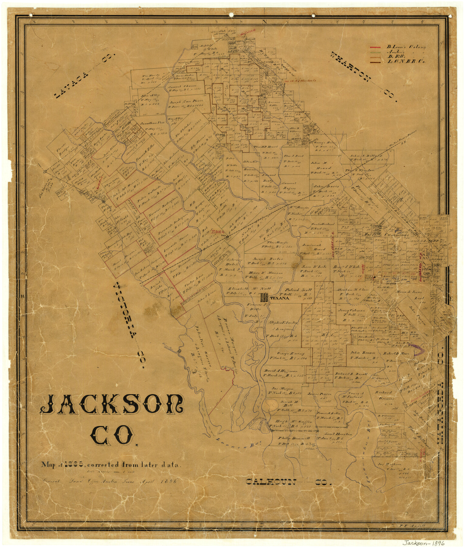
Jackson County
-
Map/Doc
3710
-
Collection
General Map Collection
-
Object Dates
4/1896 (Creation Date)
-
People and Organizations
P.F. Appell (Draftsman)
P.F. Appell (Compiler)
-
Counties
Jackson
-
Subjects
County
-
Height x Width
24.8 x 21.0 inches
63.0 x 53.3 cm
-
Features
Cox Creek
West Carancahua Creek
Turtle Bay
Granado
Carancahua Bay
Bowling Green Creek
Huisache Creek
Keller Bayou
La Bahia River
East Pass [to Lavaca Bay]
West Pass of Lavaca Bay
Lavaca Bay
Arroyo Venado
East Carancahua Creek
Arroyo de Carancahua
Atascosito Crossing
Texana
Arroyo de las Piernas
Garcitas
Arenoso Creek
Postoak Creek
Mustang Creek
Edna
Lavaca River
Chicolate Creek
Navidad River
Sutherland's Creek
Brushy Creek
Sandy Creek
NYT&M
Part of: General Map Collection
Flight Mission No. DQN-2K, Frame 142, Calhoun County

Print $20.00
- Digital $50.00
Flight Mission No. DQN-2K, Frame 142, Calhoun County
1953
Size 16.3 x 16.0 inches
Map/Doc 84311
Crosby County Working Sketch 10

Print $20.00
- Digital $50.00
Crosby County Working Sketch 10
1946
Size 44.5 x 23.7 inches
Map/Doc 68444
Caldwell County Sketch File 4a

Print $8.00
- Digital $50.00
Caldwell County Sketch File 4a
1898
Size 11.2 x 8.8 inches
Map/Doc 35835
Brewster County Sketch File NS-13

Print $4.00
- Digital $50.00
Brewster County Sketch File NS-13
1955
Size 11.1 x 8.8 inches
Map/Doc 16220
Flight Mission No. DCL-4C, Frame 96, Kenedy County

Print $20.00
- Digital $50.00
Flight Mission No. DCL-4C, Frame 96, Kenedy County
1943
Size 18.6 x 22.3 inches
Map/Doc 85817

Camp County Working Sketch 4

Print $20.00
- Digital $50.00
Camp County Working Sketch 4
2003
Size 31.6 x 25.3 inches
Map/Doc 82432
Trinity County Sketch File 16

Print $4.00
- Digital $50.00
Trinity County Sketch File 16
1879
Size 8.2 x 11.1 inches
Map/Doc 38544
Bandera County Boundary File 6

Print $42.00
- Digital $50.00
Bandera County Boundary File 6
1972
Size 14.2 x 8.9 inches
Map/Doc 50303
Flight Mission No. CUG-3P, Frame 89, Kleberg County

Print $20.00
- Digital $50.00
Flight Mission No. CUG-3P, Frame 89, Kleberg County
1956
Size 18.4 x 22.1 inches
Map/Doc 86259
[Sketch for Mineral Application 24072, San Jacinto River]
![65603, [Sketch for Mineral Application 24072, San Jacinto River], General Map Collection](https://historictexasmaps.com/wmedia_w700/maps/65603.tif.jpg)
Print $20.00
- Digital $50.00
[Sketch for Mineral Application 24072, San Jacinto River]
1929
Size 23.4 x 17.6 inches
Map/Doc 65603
Haskell County Sketch File 15a

Print $4.00
- Digital $50.00
Haskell County Sketch File 15a
Size 9.8 x 8.6 inches
Map/Doc 26161
You may also like
Right of Way & Track Map Houston & Brazos Valley Ry. operated by Houston & Brazos Valley Ry. Co., Hoskins Mound Branch

Print $40.00
- Digital $50.00
Right of Way & Track Map Houston & Brazos Valley Ry. operated by Houston & Brazos Valley Ry. Co., Hoskins Mound Branch
1924
Size 25.3 x 56.4 inches
Map/Doc 64609
Tom Green County Working Sketch 9

Print $20.00
- Digital $50.00
Tom Green County Working Sketch 9
1951
Size 31.3 x 42.2 inches
Map/Doc 69378
Brazos County Working Sketch 5

Print $20.00
- Digital $50.00
Brazos County Working Sketch 5
1978
Size 23.9 x 18.4 inches
Map/Doc 67480
Liberty County Working Sketch 75

Print $20.00
- Digital $50.00
Liberty County Working Sketch 75
1980
Size 23.2 x 23.8 inches
Map/Doc 70535
Presidio County Rolled Sketch 79

Print $20.00
- Digital $50.00
Presidio County Rolled Sketch 79
Size 22.2 x 27.0 inches
Map/Doc 7365
Hutchinson County Rolled Sketch 44-10

Print $20.00
- Digital $50.00
Hutchinson County Rolled Sketch 44-10
2002
Size 24.0 x 36.0 inches
Map/Doc 77546
Loving County Rolled Sketch 17

Print $40.00
- Digital $50.00
Loving County Rolled Sketch 17
2022
Size 38.2 x 49.3 inches
Map/Doc 97292
Sterling County Sketch File 25

Print $4.00
- Digital $50.00
Sterling County Sketch File 25
1892
Size 11.1 x 8.9 inches
Map/Doc 37192
Hudspeth County Sketch File 11b

Print $16.00
- Digital $50.00
Hudspeth County Sketch File 11b
Size 14.2 x 8.9 inches
Map/Doc 26914
Map of the British Isles designed to accompany Smith's Geography for Schools

Print $20.00
- Digital $50.00
Map of the British Isles designed to accompany Smith's Geography for Schools
1850
Size 12.1 x 9.8 inches
Map/Doc 93894
Matagorda County Working Sketch 11

Print $20.00
- Digital $50.00
Matagorda County Working Sketch 11
1957
Size 34.6 x 43.6 inches
Map/Doc 70869
Flight Mission No. BRA-16M, Frame 131, Jefferson County

Print $20.00
- Digital $50.00
Flight Mission No. BRA-16M, Frame 131, Jefferson County
1953
Size 18.4 x 22.5 inches
Map/Doc 85741