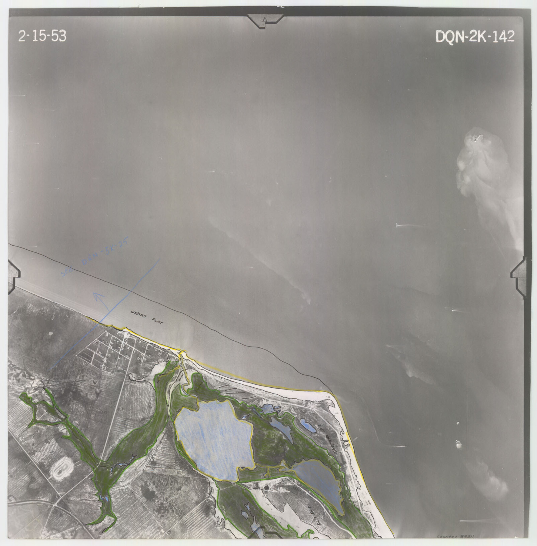
Flight Mission No. DQN-2K, Frame 142, Calhoun County
DQN-2K-142
-
Map/Doc
84311
-
Collection
General Map Collection
-
Object Dates
1953/2/15 (Creation Date)
-
People and Organizations
U. S. Department of Agriculture (Publisher)
-
Counties
Calhoun
-
Subjects
Aerial Photograph
-
Height x Width
16.3 x 16.0 inches
41.4 x 40.6 cm
-
Comments
Flown by Aero Exploration Company of Tulsa, Oklahoma.
Part of: General Map Collection
Collingsworth County Rolled Sketch 3

Print $40.00
- Digital $50.00
Collingsworth County Rolled Sketch 3
1941
Size 55.7 x 23.2 inches
Map/Doc 8639
Starr County Rolled Sketch 41

Print $6.00
- Digital $50.00
Starr County Rolled Sketch 41
1971
Size 10.8 x 15.8 inches
Map/Doc 49030
Kinney County Boundary File 1b

Print $8.00
- Digital $50.00
Kinney County Boundary File 1b
Size 14.3 x 8.7 inches
Map/Doc 64955
Victoria County Sketch File 3

Print $7.00
- Digital $50.00
Victoria County Sketch File 3
1876
Size 10.1 x 8.2 inches
Map/Doc 39514
Gillespie County

Print $20.00
- Digital $50.00
Gillespie County
1877
Size 20.1 x 24.5 inches
Map/Doc 3583
Culberson County Working Sketch 58

Print $20.00
- Digital $50.00
Culberson County Working Sketch 58
1974
Size 45.2 x 35.1 inches
Map/Doc 68512
Galveston Harbor and Channel, Texas - Rehabilitation of Galveston Groins - Location Plan of Rehabilitation

Print $4.00
- Digital $50.00
Galveston Harbor and Channel, Texas - Rehabilitation of Galveston Groins - Location Plan of Rehabilitation
1968
Size 16.0 x 20.6 inches
Map/Doc 73620
Kent County Working Sketch 10

Print $20.00
- Digital $50.00
Kent County Working Sketch 10
Size 34.1 x 43.0 inches
Map/Doc 70017
Shelby County Working Sketch 7

Print $20.00
- Digital $50.00
Shelby County Working Sketch 7
1942
Size 40.2 x 44.2 inches
Map/Doc 63860
Flight Mission No. BRA-8M, Frame 84, Jefferson County

Print $20.00
- Digital $50.00
Flight Mission No. BRA-8M, Frame 84, Jefferson County
1953
Size 18.6 x 22.4 inches
Map/Doc 85604
La Salle County Sketch File 6

Print $7.00
- Digital $50.00
La Salle County Sketch File 6
1875
Size 10.0 x 8.0 inches
Map/Doc 29453
[Sketch for Mineral Application 16696-16697, Pecos River]
![76024, [Sketch for Mineral Application 16696-16697, Pecos River], General Map Collection](https://historictexasmaps.com/wmedia_w700/maps/76024.tif.jpg)
Print $40.00
- Digital $50.00
[Sketch for Mineral Application 16696-16697, Pecos River]
Size 44.0 x 126.6 inches
Map/Doc 76024
You may also like
Outer Continental Shelf Leasing Maps (Texas Offshore Operations)

Print $20.00
- Digital $50.00
Outer Continental Shelf Leasing Maps (Texas Offshore Operations)
Size 21.0 x 15.2 inches
Map/Doc 75840
Working Sketch in Lynn County

Print $20.00
- Digital $50.00
Working Sketch in Lynn County
1921
Size 15.1 x 18.9 inches
Map/Doc 91343
Ellwood Farms Situated in Hockley, Lamb, and Hale Counties, Texas

Print $20.00
- Digital $50.00
Ellwood Farms Situated in Hockley, Lamb, and Hale Counties, Texas
Size 21.5 x 32.7 inches
Map/Doc 92227
Lipscomb County Working Sketch Graphic Index

Print $20.00
- Digital $50.00
Lipscomb County Working Sketch Graphic Index
1899
Size 41.4 x 38.4 inches
Map/Doc 76622
Matagorda County NRC Article 33.136 Sketch 23

Print $76.00
Matagorda County NRC Article 33.136 Sketch 23
2025
Map/Doc 97502
Connected Map of Austin's Colony

Print $40.00
- Digital $50.00
Connected Map of Austin's Colony
1837
Size 90.8 x 85.6 inches
Map/Doc 1944
Aransas County Sketch File 21d

Print $4.00
- Digital $50.00
Aransas County Sketch File 21d
Size 14.4 x 8.9 inches
Map/Doc 13164
McLennan County Sketch File 20

Print $2.00
- Digital $50.00
McLennan County Sketch File 20
Size 8.0 x 9.1 inches
Map/Doc 31293
Rusk County Sketch File 46

Print $4.00
Rusk County Sketch File 46
1846
Size 12.6 x 7.8 inches
Map/Doc 35595
Crockett County Sketch File 74

Print $22.00
- Digital $50.00
Crockett County Sketch File 74
1933
Size 11.4 x 8.6 inches
Map/Doc 19872
Railroad Track Map, H&TCRRCo., Falls County, Texas

Print $4.00
- Digital $50.00
Railroad Track Map, H&TCRRCo., Falls County, Texas
1918
Size 11.8 x 18.6 inches
Map/Doc 62836