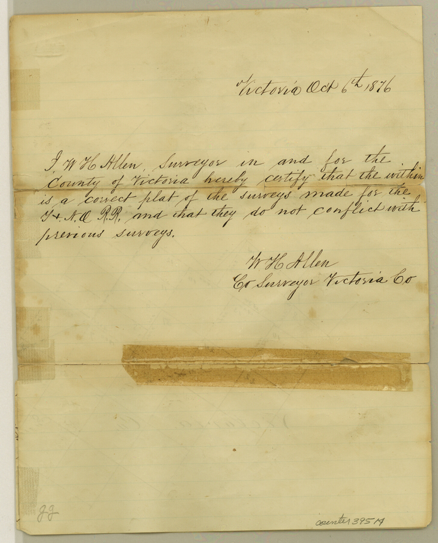
Victoria County Sketch File 3
[Sketch of Block 1, T. & N. O. R.R. Co. located at the intersection of Victoria, Jackson, and Lavaca Counties]
-
Map/Doc
39514
-
Collection
General Map Collection
-
Object Dates
10/6/1876 (Creation Date)
10/28/1876 (File Date)
-
People and Organizations
W.H. Allen (Surveyor/Engineer)
-
Counties
Victoria Jackson Lavaca
-
Subjects
Surveying Sketch File
-
Height x Width
10.1 x 8.2 inches
25.7 x 20.8 cm
-
Medium
paper, manuscript
-
Scale
1" = 2000 varas
Part of: General Map Collection
Map showing survey for proposed ship channel from Brownsville to Brazos Santiago Pass

Print $20.00
- Digital $50.00
Map showing survey for proposed ship channel from Brownsville to Brazos Santiago Pass
1912
Size 18.2 x 26.9 inches
Map/Doc 72898
Crockett County Working Sketch 89

Print $20.00
- Digital $50.00
Crockett County Working Sketch 89
1978
Size 36.4 x 44.5 inches
Map/Doc 68422
Colorado County Sketch File 18

Print $40.00
- Digital $50.00
Colorado County Sketch File 18
1897
Size 12.5 x 15.8 inches
Map/Doc 18950
Sterling County Rolled Sketch 27

Print $20.00
- Digital $50.00
Sterling County Rolled Sketch 27
Size 24.0 x 23.2 inches
Map/Doc 7852
Bosque County Working Sketch 25

Print $20.00
- Digital $50.00
Bosque County Working Sketch 25
1994
Size 36.6 x 47.9 inches
Map/Doc 67459
Houston Ship Channel, Alexander Island to Carpenter Bayou

Print $20.00
- Digital $50.00
Houston Ship Channel, Alexander Island to Carpenter Bayou
1975
Size 35.1 x 46.6 inches
Map/Doc 69911
Map of east part of West Bay & SW part of Galveston Bay, Galveston County showing subdivision for mineral development

Print $20.00
- Digital $50.00
Map of east part of West Bay & SW part of Galveston Bay, Galveston County showing subdivision for mineral development
1951
Size 32.6 x 37.6 inches
Map/Doc 2975
Erath County Working Sketch 50b

Print $20.00
- Digital $50.00
Erath County Working Sketch 50b
Size 43.4 x 25.8 inches
Map/Doc 69132
International boundary between U.S. & Mexico in Gulf of Mexico from 12 mile point easterly to 200 mile limit

Print $3.00
- Digital $50.00
International boundary between U.S. & Mexico in Gulf of Mexico from 12 mile point easterly to 200 mile limit
1976
Size 9.6 x 14.8 inches
Map/Doc 1748
Map of Eastland Co.

Print $20.00
- Digital $50.00
Map of Eastland Co.
1896
Size 43.2 x 43.1 inches
Map/Doc 78410
Map of the International and Great Northern Railroad between Austin and San Antonio, Texas

Print $40.00
- Digital $50.00
Map of the International and Great Northern Railroad between Austin and San Antonio, Texas
1881
Size 42.5 x 121.5 inches
Map/Doc 64776
Andrews County Working Sketch 4

Print $20.00
- Digital $50.00
Andrews County Working Sketch 4
1954
Size 42.8 x 19.2 inches
Map/Doc 67050
You may also like
Flight Mission No. DCL-6C, Frame 76, Kenedy County

Print $20.00
- Digital $50.00
Flight Mission No. DCL-6C, Frame 76, Kenedy County
1943
Size 18.6 x 22.3 inches
Map/Doc 85918
Flight Mission No. DQO-8K, Frame 69, Galveston County

Print $20.00
- Digital $50.00
Flight Mission No. DQO-8K, Frame 69, Galveston County
1952
Size 18.8 x 22.5 inches
Map/Doc 85173
Harris County Sketch File 66

Print $20.00
- Digital $50.00
Harris County Sketch File 66
Size 16.9 x 27.5 inches
Map/Doc 11661
Victoria County Rolled Sketch 1

Print $20.00
- Digital $50.00
Victoria County Rolled Sketch 1
1902
Size 20.5 x 17.5 inches
Map/Doc 8150
Kleberg County Boundary File 3

Print $10.00
- Digital $50.00
Kleberg County Boundary File 3
Size 9.5 x 6.1 inches
Map/Doc 64981
Eastland County Working Sketch 58

Print $20.00
- Digital $50.00
Eastland County Working Sketch 58
1985
Size 25.5 x 39.6 inches
Map/Doc 68839
Hudspeth County Working Sketch 41

Print $20.00
- Digital $50.00
Hudspeth County Working Sketch 41
1981
Size 18.3 x 37.1 inches
Map/Doc 66326
Flight Mission No. DAG-17K, Frame 75, Matagorda County

Print $20.00
- Digital $50.00
Flight Mission No. DAG-17K, Frame 75, Matagorda County
1952
Size 16.5 x 16.5 inches
Map/Doc 86334
Wise County Sketch File 11

Print $4.00
- Digital $50.00
Wise County Sketch File 11
1860
Size 12.8 x 8.0 inches
Map/Doc 40544
Reeves County Working Sketch 60

Print $20.00
- Digital $50.00
Reeves County Working Sketch 60
1981
Size 24.7 x 36.3 inches
Map/Doc 63503

Map of McMullen County

Print $20.00
Map of McMullen County
1879
Size 28.6 x 19.3 inches
Map/Doc 88975