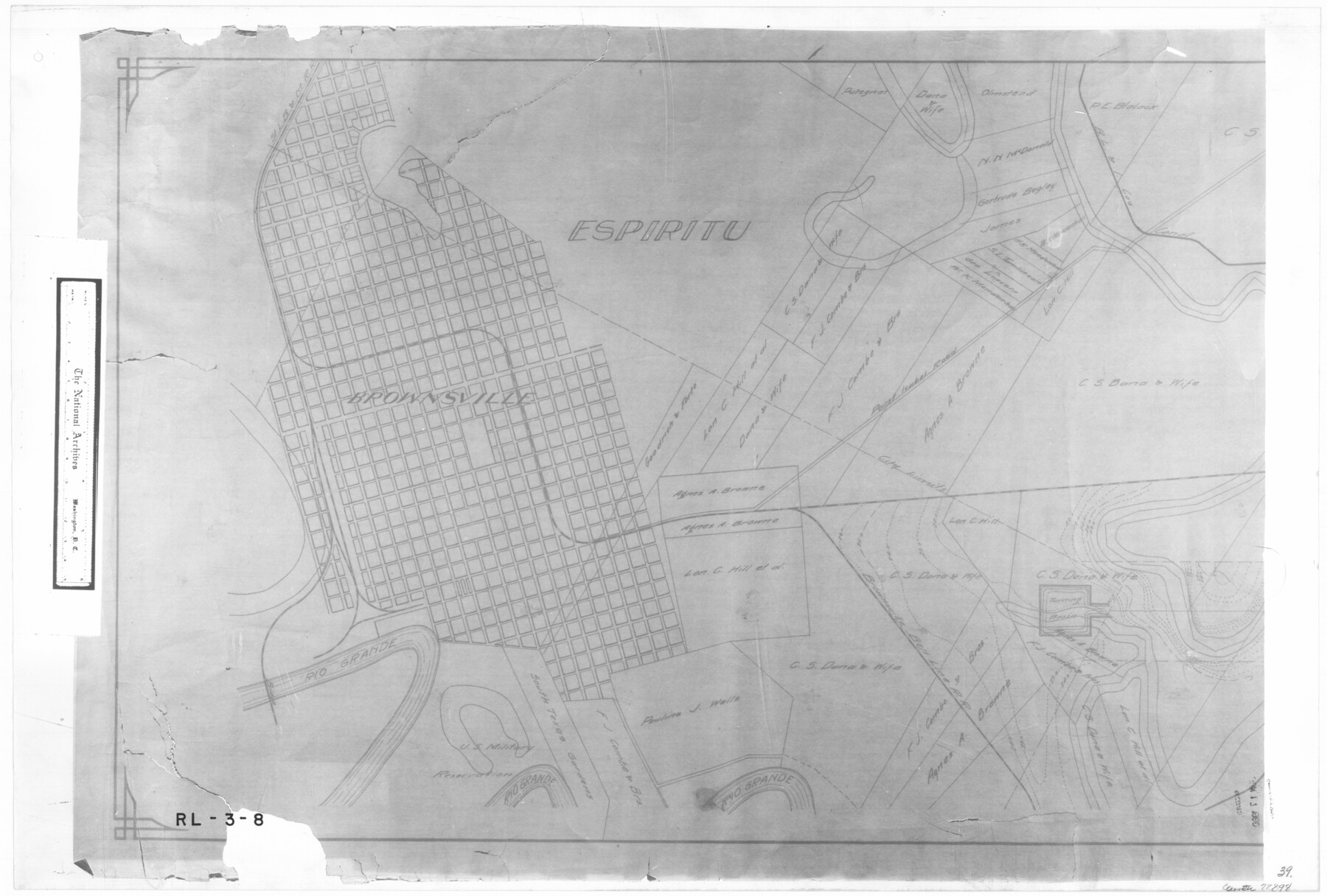
Map showing survey for proposed ship channel from Brownsville to Brazos Santiago Pass
RL-3-8
-
Map/Doc
72898
-
Collection
General Map Collection
-
Object Dates
1912 (Creation Date)
-
People and Organizations
Firm of Davis & Tomm Civil Engineers (Author)
-
Subjects
Gulf of Mexico
-
Height x Width
18.2 x 26.9 inches
46.2 x 68.3 cm
-
Comments
B/W photostat copy from National Archives in multiple pieces.
Part of: General Map Collection
Hale County Working Sketch 5

Print $20.00
- Digital $50.00
Hale County Working Sketch 5
1980
Size 15.0 x 11.1 inches
Map/Doc 63325
Red River Co.

Print $20.00
- Digital $50.00
Red River Co.
1905
Size 46.7 x 39.6 inches
Map/Doc 66994
Hopkins County

Print $20.00
- Digital $50.00
Hopkins County
1942
Size 43.6 x 41.6 inches
Map/Doc 1858
Young County Sketch File 1

Print $8.00
- Digital $50.00
Young County Sketch File 1
1853
Size 7.9 x 9.7 inches
Map/Doc 40843
[Corpus Christi Bay, Padre Island, Mustang Island, Laguna de la Madre, King and Kenedy's Pasture]
![73041, [Corpus Christi Bay, Padre Island, Mustang Island, Laguna de la Madre, King and Kenedy's Pasture], General Map Collection](https://historictexasmaps.com/wmedia_w700/maps/73041.tif.jpg)
Print $20.00
- Digital $50.00
[Corpus Christi Bay, Padre Island, Mustang Island, Laguna de la Madre, King and Kenedy's Pasture]
Size 26.2 x 18.1 inches
Map/Doc 73041
Navigation Maps of Gulf Intracoastal Waterway, Port Arthur to Brownsville, Texas

Print $4.00
- Digital $50.00
Navigation Maps of Gulf Intracoastal Waterway, Port Arthur to Brownsville, Texas
1951
Size 16.7 x 21.5 inches
Map/Doc 65442
W. Alvin Lloyd's Southern Rail-Road Map

Print $20.00
- Digital $50.00
W. Alvin Lloyd's Southern Rail-Road Map
1863
Size 18.4 x 23.7 inches
Map/Doc 97496
Map showing the Distribution of Slaves in the Southern States

Print $20.00
- Digital $50.00
Map showing the Distribution of Slaves in the Southern States
1861
Size 15.2 x 18.3 inches
Map/Doc 96634
Culberson County Sketch File 21

Print $20.00
- Digital $50.00
Culberson County Sketch File 21
1937
Size 11.2 x 8.8 inches
Map/Doc 20224
Dimmit County Boundary File 2

Print $4.00
- Digital $50.00
Dimmit County Boundary File 2
Size 10.0 x 7.9 inches
Map/Doc 52564
Stephens County Working Sketch 7

Print $20.00
- Digital $50.00
Stephens County Working Sketch 7
1919
Size 26.9 x 16.6 inches
Map/Doc 63950
Flight Mission No. CGI-4N, Frame 29, Cameron County

Print $20.00
- Digital $50.00
Flight Mission No. CGI-4N, Frame 29, Cameron County
1954
Size 18.6 x 22.4 inches
Map/Doc 84662
You may also like
Ward County Rolled Sketch 13

Print $20.00
- Digital $50.00
Ward County Rolled Sketch 13
1938
Size 30.0 x 20.0 inches
Map/Doc 8156
Goliad County Working Sketch Graphic Index

Print $20.00
- Digital $50.00
Goliad County Working Sketch Graphic Index
1946
Size 42.2 x 44.9 inches
Map/Doc 76555
Uvalde County

Print $20.00
- Digital $50.00
Uvalde County
1915
Size 46.0 x 46.0 inches
Map/Doc 16910
Pecos County Sketch File 61

Print $40.00
- Digital $50.00
Pecos County Sketch File 61
1918
Size 16.3 x 15.3 inches
Map/Doc 33788
Hardeman County

Print $20.00
- Digital $50.00
Hardeman County
1876
Size 24.1 x 31.5 inches
Map/Doc 3625
Kendall County Working Sketch 22

Print $20.00
- Digital $50.00
Kendall County Working Sketch 22
1971
Size 41.6 x 34.7 inches
Map/Doc 66694
Map of Rains County

Print $20.00
- Digital $50.00
Map of Rains County
1873
Size 12.5 x 11.6 inches
Map/Doc 4618
Map of a part of Laguna Madre showing subdivision for mineral development

Print $20.00
- Digital $50.00
Map of a part of Laguna Madre showing subdivision for mineral development
1948
Size 42.9 x 31.0 inches
Map/Doc 2913
Houston County Working Sketch 33

Print $40.00
- Digital $50.00
Houston County Working Sketch 33
1987
Size 37.6 x 58.7 inches
Map/Doc 66263
Reagan County Rolled Sketch 40

Print $40.00
- Digital $50.00
Reagan County Rolled Sketch 40
Size 90.0 x 39.3 inches
Map/Doc 9831
Cherokee County Rolled Sketch 3

Print $40.00
- Digital $50.00
Cherokee County Rolled Sketch 3
1955
Size 55.5 x 35.2 inches
Map/Doc 8597
