Dimmit County Boundary File 2
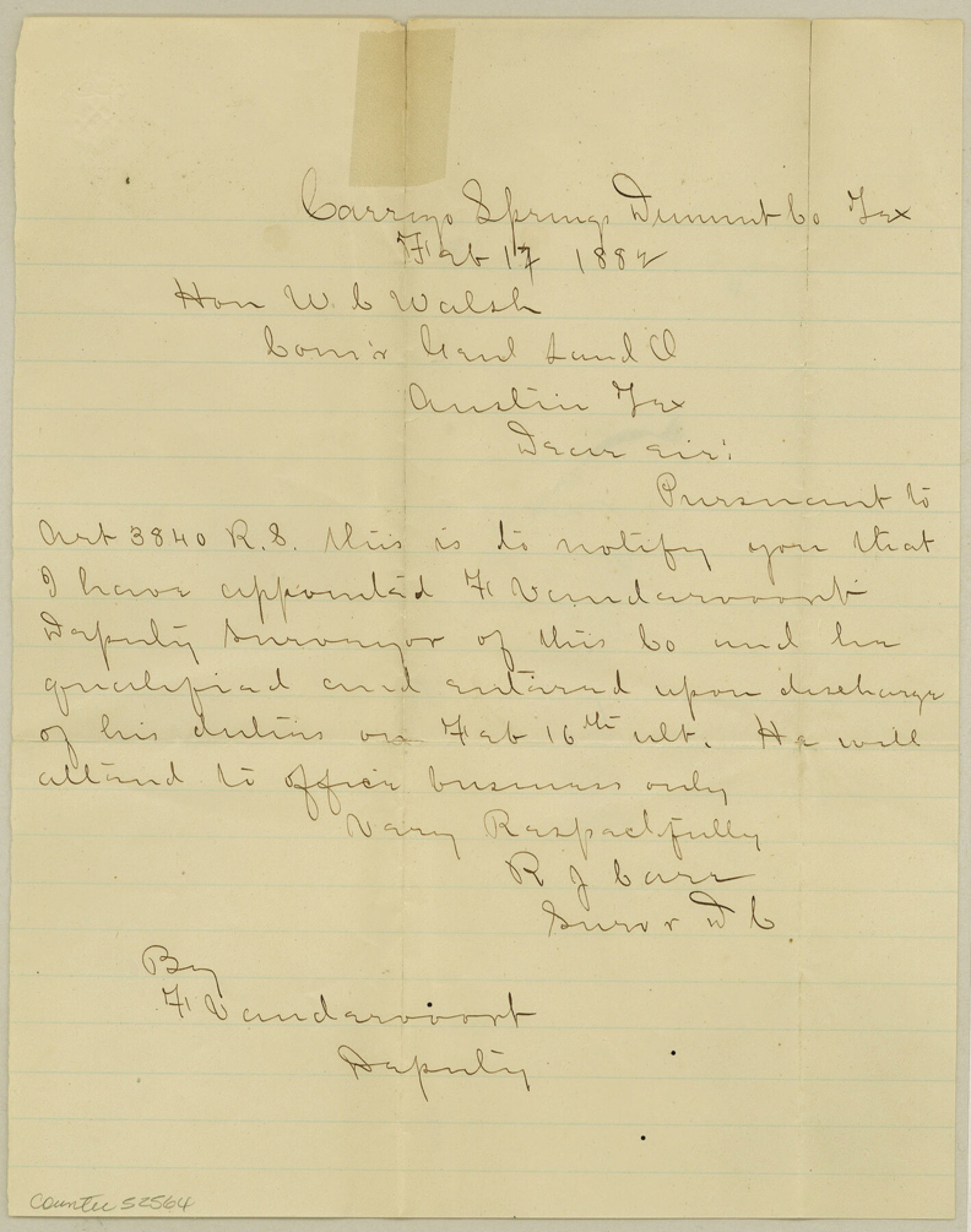
Dimmit Co. apptment. of Deputy
-
Map/Doc
52564
-
Collection
General Map Collection
-
Counties
Dimmit
-
Subjects
County Boundaries
-
Height x Width
10.0 x 7.9 inches
25.4 x 20.1 cm
Part of: General Map Collection
Galveston Bay, Texas
![65390, Galveston Bay, Texas, General Map Collection](https://historictexasmaps.com/wmedia_w700/maps/65390-GC.tif.jpg)
Print $20.00
- Digital $50.00
Galveston Bay, Texas
1905
Size 24.8 x 18.5 inches
Map/Doc 65390
Live Oak County Working Sketch 1
![70586, Live Oak County Working Sketch 1, General Map Collection](https://historictexasmaps.com/wmedia_w700/maps/70586.tif.jpg)
Print $20.00
- Digital $50.00
Live Oak County Working Sketch 1
Size 20.4 x 29.1 inches
Map/Doc 70586
Sketch showing progress of topographical work Laguna Madre and vicinity from Rainey Is. to Baffins Bay, Coast of Texas Sect. IX [and accompanying letter]
![72960, Sketch showing progress of topographical work Laguna Madre and vicinity from Rainey Is. to Baffins Bay, Coast of Texas Sect. IX [and accompanying letter], General Map Collection](https://historictexasmaps.com/wmedia_w700/maps/72960.tif.jpg)
Print $2.00
- Digital $50.00
Sketch showing progress of topographical work Laguna Madre and vicinity from Rainey Is. to Baffins Bay, Coast of Texas Sect. IX [and accompanying letter]
1881
Size 11.1 x 8.8 inches
Map/Doc 72960
Flight Mission No. BRA-16M, Frame 105, Jefferson County
![85717, Flight Mission No. BRA-16M, Frame 105, Jefferson County, General Map Collection](https://historictexasmaps.com/wmedia_w700/pdf_converted_jpg/qi_pdf_thumbnail_32914.jpg)
Print $20.00
- Digital $50.00
Flight Mission No. BRA-16M, Frame 105, Jefferson County
1953
Size 18.5 x 22.1 inches
Map/Doc 85717
Map of Surveys Made for the T&PRR in Andrews & Martin Counties, Blocks 37, 38, 39, 40 & 41, Reserve West of the Colorado River
![2229, Map of Surveys Made for the T&PRR in Andrews & Martin Counties, Blocks 37, 38, 39, 40 & 41, Reserve West of the Colorado River, General Map Collection](https://historictexasmaps.com/wmedia_w700/maps/2229.tif.jpg)
Print $20.00
- Digital $50.00
Map of Surveys Made for the T&PRR in Andrews & Martin Counties, Blocks 37, 38, 39, 40 & 41, Reserve West of the Colorado River
1876
Size 42.0 x 36.8 inches
Map/Doc 2229
Galveston County Sketch File 31
![11534, Galveston County Sketch File 31, General Map Collection](https://historictexasmaps.com/wmedia_w700/pdf_converted_jpg/qi_pdf_thumbnail_7974.jpg)
Print $20.00
- Digital $50.00
Galveston County Sketch File 31
1916
Size 23.7 x 13.6 inches
Map/Doc 11534
[Beaumont, Sour Lake and Western Ry. Right of Way and Alignment - Frisco]
![64116, [Beaumont, Sour Lake and Western Ry. Right of Way and Alignment - Frisco], General Map Collection](https://historictexasmaps.com/wmedia_w700/maps/64116.tif.jpg)
Print $20.00
- Digital $50.00
[Beaumont, Sour Lake and Western Ry. Right of Way and Alignment - Frisco]
1910
Size 20.3 x 46.1 inches
Map/Doc 64116
Uvalde County Working Sketch 54
![72124, Uvalde County Working Sketch 54, General Map Collection](https://historictexasmaps.com/wmedia_w700/maps/72124.tif.jpg)
Print $20.00
- Digital $50.00
Uvalde County Working Sketch 54
Size 39.6 x 32.3 inches
Map/Doc 72124
Corpus Christi Bay
![73473, Corpus Christi Bay, General Map Collection](https://historictexasmaps.com/wmedia_w700/maps/73473.tif.jpg)
Print $20.00
- Digital $50.00
Corpus Christi Bay
1971
Size 36.2 x 47.6 inches
Map/Doc 73473
Val Verde County Working Sketch 92
![72227, Val Verde County Working Sketch 92, General Map Collection](https://historictexasmaps.com/wmedia_w700/maps/72227.tif.jpg)
Print $20.00
- Digital $50.00
Val Verde County Working Sketch 92
Size 30.3 x 35.3 inches
Map/Doc 72227
Angelina County Sketch File 26
![10817, Angelina County Sketch File 26, General Map Collection](https://historictexasmaps.com/wmedia_w700/pdf_converted_jpg/qi_pdf_thumbnail_7411.jpg)
Print $40.00
- Digital $50.00
Angelina County Sketch File 26
1909
Size 18.0 x 23.0 inches
Map/Doc 10817
Deaf Smith County Working Sketch 5
![68645, Deaf Smith County Working Sketch 5, General Map Collection](https://historictexasmaps.com/wmedia_w700/maps/68645.tif.jpg)
Print $40.00
- Digital $50.00
Deaf Smith County Working Sketch 5
Size 37.0 x 53.9 inches
Map/Doc 68645
You may also like
General Highway Map, Chambers County, Texas
![79044, General Highway Map, Chambers County, Texas, Texas State Library and Archives](https://historictexasmaps.com/wmedia_w700/maps/79044.tif.jpg)
Print $20.00
General Highway Map, Chambers County, Texas
1940
Size 18.4 x 25.3 inches
Map/Doc 79044
Map of Walker County, Texas
![655, Map of Walker County, Texas, Maddox Collection](https://historictexasmaps.com/wmedia_w700/maps/655.tif.jpg)
Print $20.00
- Digital $50.00
Map of Walker County, Texas
1879
Size 19.9 x 16.6 inches
Map/Doc 655
Kerr County Working Sketch 5
![70036, Kerr County Working Sketch 5, General Map Collection](https://historictexasmaps.com/wmedia_w700/maps/70036.tif.jpg)
Print $20.00
- Digital $50.00
Kerr County Working Sketch 5
Size 21.9 x 19.8 inches
Map/Doc 70036
Motley County Sketch File 7 (N)
![42140, Motley County Sketch File 7 (N), General Map Collection](https://historictexasmaps.com/wmedia_w700/pdf_converted_jpg/qi_pdf_thumbnail_15345.jpg)
Print $20.00
- Digital $50.00
Motley County Sketch File 7 (N)
1901
Size 16.0 x 19.8 inches
Map/Doc 42140
Coast Chart No. 105 - Galveston Bay to Oyster Bay, Texas
![69926, Coast Chart No. 105 - Galveston Bay to Oyster Bay, Texas, General Map Collection](https://historictexasmaps.com/wmedia_w700/maps/69926.tif.jpg)
Print $20.00
- Digital $50.00
Coast Chart No. 105 - Galveston Bay to Oyster Bay, Texas
1884
Size 24.1 x 29.6 inches
Map/Doc 69926
Houston County Sketch File 22
![26789, Houston County Sketch File 22, General Map Collection](https://historictexasmaps.com/wmedia_w700/pdf_converted_jpg/qi_pdf_thumbnail_11993.jpg)
Print $8.00
- Digital $50.00
Houston County Sketch File 22
1852
Size 12.6 x 8.2 inches
Map/Doc 26789
Coleman County Sketch File 26
![18712, Coleman County Sketch File 26, General Map Collection](https://historictexasmaps.com/wmedia_w700/pdf_converted_jpg/qi_pdf_thumbnail_10206.jpg)
Print $40.00
- Digital $50.00
Coleman County Sketch File 26
1873
Size 12.7 x 15.5 inches
Map/Doc 18712
Cameron County Rolled Sketch US
![5398, Cameron County Rolled Sketch US, General Map Collection](https://historictexasmaps.com/wmedia_w700/maps/5398.tif.jpg)
Print $20.00
- Digital $50.00
Cameron County Rolled Sketch US
1913
Size 31.1 x 26.3 inches
Map/Doc 5398
Map of Brazoria County
![16945, Map of Brazoria County, General Map Collection](https://historictexasmaps.com/wmedia_w700/maps/16945-1.tif.jpg)
Print $40.00
- Digital $50.00
Map of Brazoria County
1891
Size 56.9 x 58.4 inches
Map/Doc 16945
Cooke County Sketch File 41
![19308, Cooke County Sketch File 41, General Map Collection](https://historictexasmaps.com/wmedia_w700/pdf_converted_jpg/qi_pdf_thumbnail_10391.jpg)
Print $36.00
- Digital $50.00
Cooke County Sketch File 41
1928
Size 11.3 x 8.9 inches
Map/Doc 19308
Garza County Sketch File G
![24026, Garza County Sketch File G, General Map Collection](https://historictexasmaps.com/wmedia_w700/pdf_converted_jpg/qi_pdf_thumbnail_11341.jpg)
Print $8.00
- Digital $50.00
Garza County Sketch File G
1904
Size 14.3 x 8.6 inches
Map/Doc 24026
Denton County Working Sketch 20
![68625, Denton County Working Sketch 20, General Map Collection](https://historictexasmaps.com/wmedia_w700/maps/68625.tif.jpg)
Print $6.00
- Digital $50.00
Denton County Working Sketch 20
Size 31.6 x 33.2 inches
Map/Doc 68625