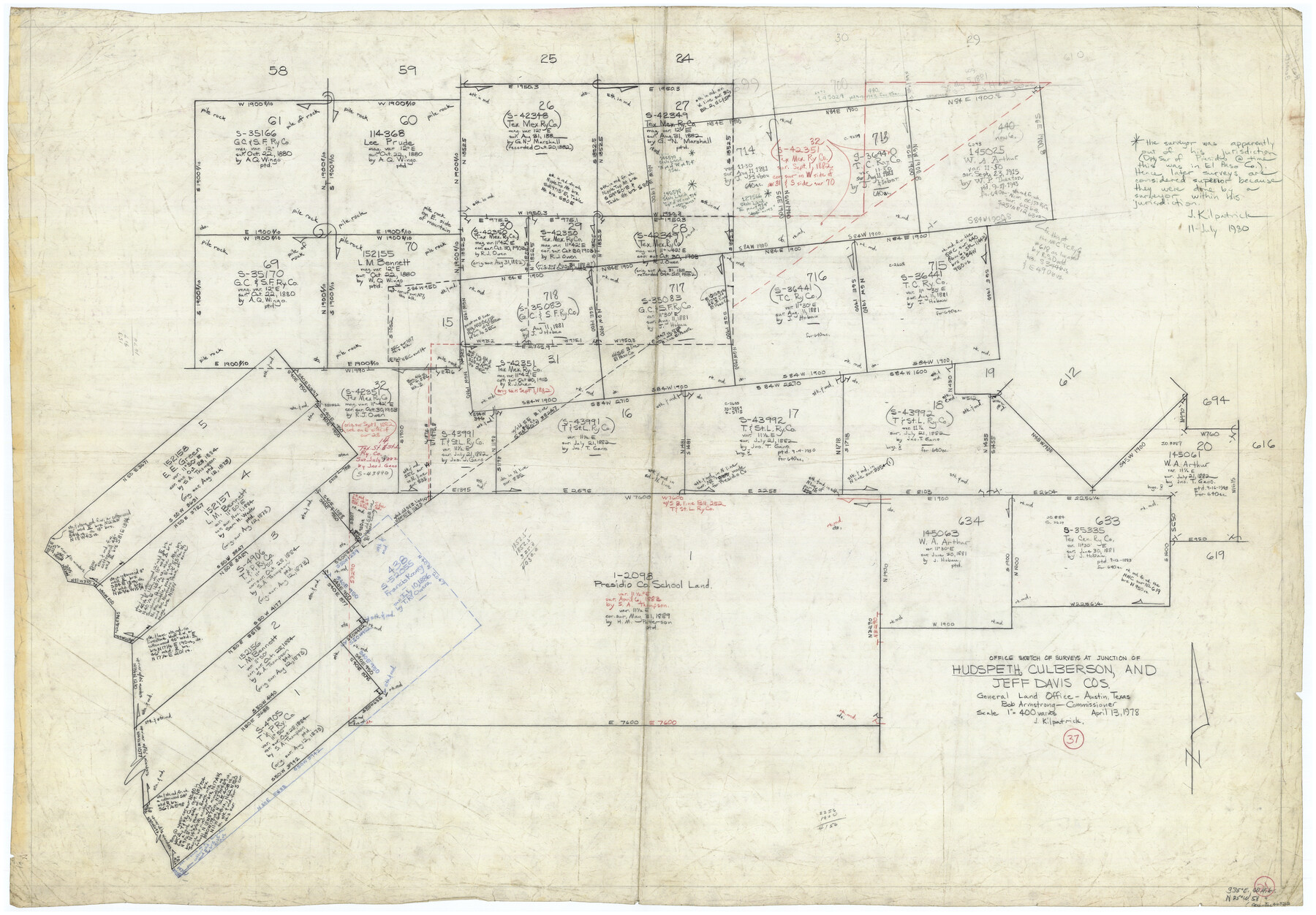
Hudspeth County Working Sketch 37
-
Map/Doc
66322
-
Collection
General Map Collection
-
Object Dates
4/13/1978 (Creation Date)
-
People and Organizations
Joan Kilpatrick (Draftsman)
-
Counties
Hudspeth Culberson Jeff Davis
-
Subjects
Surveying Working Sketch
-
Height x Width
32.8 x 46.8 inches
83.3 x 118.9 cm
-
Scale
1" = 400 varas
Part of: General Map Collection
Flight Mission No. DQO-8K, Frame 142, Galveston County

Print $20.00
- Digital $50.00
Flight Mission No. DQO-8K, Frame 142, Galveston County
1952
Size 18.6 x 22.3 inches
Map/Doc 85204
Crosby County Working Sketch 1

Print $20.00
- Digital $50.00
Crosby County Working Sketch 1
Size 28.0 x 26.0 inches
Map/Doc 68435
Leon County Rolled Sketch 4

Print $20.00
- Digital $50.00
Leon County Rolled Sketch 4
1947
Size 34.6 x 35.4 inches
Map/Doc 9426

Menard County Sketch File 20

Print $8.00
- Digital $50.00
Menard County Sketch File 20
1911
Size 14.2 x 8.7 inches
Map/Doc 31548
Upshur County Boundary File 1

Print $30.00
- Digital $50.00
Upshur County Boundary File 1
Size 9.4 x 8.6 inches
Map/Doc 59500
Duval County Rolled Sketch 41

Print $20.00
- Digital $50.00
Duval County Rolled Sketch 41
1966
Size 23.3 x 21.1 inches
Map/Doc 5758
[F. W. & D. C. Ry. Co. Alignment and Right of Way Map, Clay County]
![64747, [F. W. & D. C. Ry. Co. Alignment and Right of Way Map, Clay County], General Map Collection](https://historictexasmaps.com/wmedia_w700/maps/64747-GC.tif.jpg)
Print $20.00
- Digital $50.00
[F. W. & D. C. Ry. Co. Alignment and Right of Way Map, Clay County]
1927
Size 18.7 x 11.9 inches
Map/Doc 64747
Orange County Sketch File 14

Print $20.00
- Digital $50.00
Orange County Sketch File 14
Size 19.9 x 32.9 inches
Map/Doc 12118
Montgomery County Working Sketch 31

Print $20.00
- Digital $50.00
Montgomery County Working Sketch 31
Size 24.7 x 18.7 inches
Map/Doc 71138
Newton County Rolled Sketch 23
Print $20.00
- Digital $50.00
Newton County Rolled Sketch 23
1893
Size 22.7 x 18.5 inches
Map/Doc 6850
Edwards County Working Sketch 130

Print $20.00
- Digital $50.00
Edwards County Working Sketch 130
1982
Size 29.3 x 26.8 inches
Map/Doc 69006
You may also like
Freestone County Working Sketch 17

Print $20.00
- Digital $50.00
Freestone County Working Sketch 17
1980
Size 44.8 x 31.0 inches
Map/Doc 69259
Kenedy County Rolled Sketch 15

Print $15.00
- Digital $50.00
Kenedy County Rolled Sketch 15
1942
Size 10.2 x 15.2 inches
Map/Doc 46426

Harris County Working Sketch 28

Print $20.00
- Digital $50.00
Harris County Working Sketch 28
Size 34.4 x 43.1 inches
Map/Doc 65920
The Mexican Municipality of San Patricio. April 1834

Print $20.00
The Mexican Municipality of San Patricio. April 1834
2020
Size 16.0 x 21.7 inches
Map/Doc 96034
Flight Mission No. DCL-7C, Frame 38, Kenedy County

Print $20.00
- Digital $50.00
Flight Mission No. DCL-7C, Frame 38, Kenedy County
1943
Size 15.4 x 15.1 inches
Map/Doc 86026
Jefferson County NRC Article 33.136 Sketch 9

Print $22.00
- Digital $50.00
Jefferson County NRC Article 33.136 Sketch 9
2011
Size 24.0 x 36.0 inches
Map/Doc 94517
Flight Mission No. BRA-16M, Frame 61, Jefferson County

Print $20.00
- Digital $50.00
Flight Mission No. BRA-16M, Frame 61, Jefferson County
1953
Size 18.6 x 22.2 inches
Map/Doc 85678
Flight Mission No. DIX-10P, Frame 83, Aransas County

Print $20.00
- Digital $50.00
Flight Mission No. DIX-10P, Frame 83, Aransas County
1956
Size 18.7 x 22.3 inches
Map/Doc 83944
Sectional Map No. 3 of the lands and of the line of the Texas & Pacific Ry. Co. in Reeves and parts of Tom Green, Pecos, Presidio & El Paso Cos.

Print $20.00
- Digital $50.00
Sectional Map No. 3 of the lands and of the line of the Texas & Pacific Ry. Co. in Reeves and parts of Tom Green, Pecos, Presidio & El Paso Cos.
1885
Size 24.2 x 18.9 inches
Map/Doc 4858
Map of The Surveyed Part of Peters Colony Texas

Print $40.00
- Digital $50.00
Map of The Surveyed Part of Peters Colony Texas
1852
Size 56.5 x 41.0 inches
Map/Doc 1966
Gaines County Working Sketch 31

Print $20.00
- Digital $50.00
Gaines County Working Sketch 31
1990
Size 37.4 x 26.8 inches
Map/Doc 69331