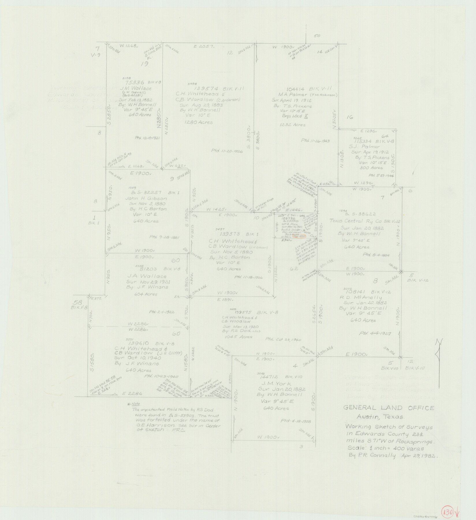
Edwards County Working Sketch 130
-
Map/Doc
69006
-
Collection
General Map Collection
-
Object Dates
4/29/1982 (Creation Date)
-
People and Organizations
Preston R. Connally (Draftsman)
-
Counties
Edwards
-
Subjects
Surveying Working Sketch
-
Height x Width
29.3 x 26.8 inches
74.4 x 68.1 cm
-
Scale
1" = 400 varas
Part of: General Map Collection
[Town lots on Galveston Island]
![11, [Town lots on Galveston Island], General Map Collection](https://historictexasmaps.com/wmedia_w700/maps/11.tif.jpg)
Print $20.00
- Digital $50.00
[Town lots on Galveston Island]
1839
Size 18.8 x 23.0 inches
Map/Doc 11
No. 2 Chart of Corpus Christi Pass, Texas

Print $20.00
- Digital $50.00
No. 2 Chart of Corpus Christi Pass, Texas
1878
Size 18.2 x 27.3 inches
Map/Doc 73017
Presidio County Rolled Sketch 13

Print $40.00
- Digital $50.00
Presidio County Rolled Sketch 13
1882
Size 59.1 x 43.9 inches
Map/Doc 78487
Menard County Sketch File 8

Print $20.00
- Digital $50.00
Menard County Sketch File 8
Size 19.7 x 28.5 inches
Map/Doc 12073
Webb County Sketch File 12a

Print $20.00
- Digital $50.00
Webb County Sketch File 12a
1886
Size 20.7 x 31.4 inches
Map/Doc 12628
Lipscomb County Boundary File 9

Print $8.00
- Digital $50.00
Lipscomb County Boundary File 9
Size 11.2 x 8.5 inches
Map/Doc 56335
Map of Jones County

Print $20.00
- Digital $50.00
Map of Jones County
1898
Size 41.9 x 39.8 inches
Map/Doc 4996
Grimes County Rolled Sketch 2

Print $20.00
- Digital $50.00
Grimes County Rolled Sketch 2
Size 29.2 x 24.3 inches
Map/Doc 6043
Flight Mission No. DAG-28K, Frame 29, Matagorda County

Print $20.00
- Digital $50.00
Flight Mission No. DAG-28K, Frame 29, Matagorda County
1953
Size 16.2 x 16.1 inches
Map/Doc 86597
Irion County Boundary File 3a

Print $2.00
- Digital $50.00
Irion County Boundary File 3a
Size 12.9 x 8.3 inches
Map/Doc 55349
Haskell County Sketch File 11

Print $6.00
- Digital $50.00
Haskell County Sketch File 11
1886
Size 16.0 x 10.7 inches
Map/Doc 26140
Edwards County Working Sketch 39

Print $20.00
- Digital $50.00
Edwards County Working Sketch 39
1948
Size 28.7 x 32.3 inches
Map/Doc 68915
You may also like
Reconnoissance of Sabine Pass

Print $20.00
Reconnoissance of Sabine Pass
1853
Size 12.4 x 10.3 inches
Map/Doc 76281
General Highway Map, Kleberg County, Texas

Print $20.00
General Highway Map, Kleberg County, Texas
1961
Size 24.6 x 18.3 inches
Map/Doc 79559
Flight Mission No. DAH-9M, Frame 164, Orange County

Print $20.00
- Digital $50.00
Flight Mission No. DAH-9M, Frame 164, Orange County
1953
Size 18.6 x 22.3 inches
Map/Doc 86863
[Beaumont, Sour Lake and Western Ry. Right of Way and Alignment - Frisco]
![64127, [Beaumont, Sour Lake and Western Ry. Right of Way and Alignment - Frisco], General Map Collection](https://historictexasmaps.com/wmedia_w700/maps/64127.tif.jpg)
Print $20.00
- Digital $50.00
[Beaumont, Sour Lake and Western Ry. Right of Way and Alignment - Frisco]
1910
Size 20.1 x 45.8 inches
Map/Doc 64127
J. N. Watson Subdivision of Blocks 1, 6, 7, and 43, Lamesa, Texas

Print $20.00
- Digital $50.00
J. N. Watson Subdivision of Blocks 1, 6, 7, and 43, Lamesa, Texas
Size 11.6 x 24.8 inches
Map/Doc 92574
Pecos County Working Sketch 83

Print $20.00
- Digital $50.00
Pecos County Working Sketch 83
1961
Size 18.7 x 28.7 inches
Map/Doc 71555
Upshur County Sketch File 3a

Print $2.00
- Digital $50.00
Upshur County Sketch File 3a
Size 6.5 x 7.1 inches
Map/Doc 38736
Hockley County Sketch File 9

Print $40.00
- Digital $50.00
Hockley County Sketch File 9
1912
Size 48.2 x 12.8 inches
Map/Doc 10491
Harris County Rolled Sketch 96B

Print $20.00
- Digital $50.00
Harris County Rolled Sketch 96B
Size 15.8 x 15.6 inches
Map/Doc 10681
Parker County Working Sketch 3

Print $20.00
- Digital $50.00
Parker County Working Sketch 3
1941
Map/Doc 71453
Lamb County Sketch File C1

Print $20.00
- Digital $50.00
Lamb County Sketch File C1
1904
Size 26.5 x 21.7 inches
Map/Doc 11974
Reeves County Working Sketch 60

Print $20.00
- Digital $50.00
Reeves County Working Sketch 60
1981
Size 24.7 x 36.3 inches
Map/Doc 63503