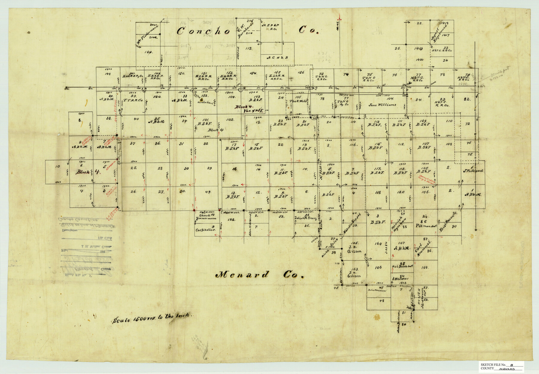
Menard County Sketch File 8
Sketch on Line of Menard & Concho Counties, Texas
-
Map/Doc
12073
-
Collection
General Map Collection
-
Counties
Menard Concho McCulloch
-
Subjects
Surveying Sketch File
-
Height x Width
19.7 x 28.5 inches
50.0 x 72.4 cm
-
Medium
paper, manuscript
-
Scale
1" = 1500 varas
Part of: General Map Collection
Reeves County Rolled Sketch 30

Print $20.00
- Digital $50.00
Reeves County Rolled Sketch 30
1988
Size 18.4 x 24.4 inches
Map/Doc 7499
Hansford County

Print $20.00
- Digital $50.00
Hansford County
1932
Size 39.7 x 39.0 inches
Map/Doc 95519
Ward County State of Texas

Print $20.00
- Digital $50.00
Ward County State of Texas
1888
Size 22.6 x 26.0 inches
Map/Doc 4641
Kimble County Sketch File 36

Print $20.00
- Digital $50.00
Kimble County Sketch File 36
1963
Size 22.2 x 25.0 inches
Map/Doc 11932
Hemphill County Rolled Sketch 16

Print $40.00
- Digital $50.00
Hemphill County Rolled Sketch 16
1961
Size 65.4 x 26.9 inches
Map/Doc 9156
Edwards County Working Sketch 33

Print $40.00
- Digital $50.00
Edwards County Working Sketch 33
1947
Size 42.6 x 50.2 inches
Map/Doc 68909
McMullen County Working Sketch 36

Print $20.00
- Digital $50.00
McMullen County Working Sketch 36
1963
Size 40.1 x 41.5 inches
Map/Doc 70737
Houston County Sketch File 23

Print $6.00
- Digital $50.00
Houston County Sketch File 23
1852
Size 6.5 x 5.2 inches
Map/Doc 26793
Harrison County Working Sketch 6

Print $20.00
- Digital $50.00
Harrison County Working Sketch 6
1954
Size 27.6 x 38.7 inches
Map/Doc 66026
Gaines County

Print $40.00
- Digital $50.00
Gaines County
1956
Size 43.8 x 55.0 inches
Map/Doc 73154
Crosby County Sketch File 28

Print $20.00
- Digital $50.00
Crosby County Sketch File 28
Size 33.4 x 37.4 inches
Map/Doc 10353
Chambers County Sketch File 54

Print $3.00
- Digital $50.00
Chambers County Sketch File 54
1895
Size 16.5 x 10.3 inches
Map/Doc 18093
You may also like
Polk County Sketch File 16

Print $4.00
- Digital $50.00
Polk County Sketch File 16
1861
Size 7.9 x 11.1 inches
Map/Doc 34161
Brown County Sketch File 4

Print $4.00
- Digital $50.00
Brown County Sketch File 4
1858
Size 12.7 x 8.1 inches
Map/Doc 16585

Refugio County Sketch File 27

Print $18.00
- Digital $50.00
Refugio County Sketch File 27
1993
Size 11.4 x 8.8 inches
Map/Doc 35294
Presidio County Boundary File 1

Print $22.00
- Digital $50.00
Presidio County Boundary File 1
Size 12.8 x 8.2 inches
Map/Doc 58041
McCulloch County Sketch File 5A

Print $20.00
- Digital $50.00
McCulloch County Sketch File 5A
Size 14.8 x 17.4 inches
Map/Doc 12056
Orange County NRC Article 33.136 Sketch 4

Print $24.00
- Digital $50.00
Orange County NRC Article 33.136 Sketch 4
2011
Size 22.6 x 31.2 inches
Map/Doc 93271
Fractional Township No. 11 South Range No. 27 East of the Indian Meridian, Indian Territory

Print $20.00
- Digital $50.00
Fractional Township No. 11 South Range No. 27 East of the Indian Meridian, Indian Territory
1897
Size 19.2 x 24.3 inches
Map/Doc 75247
Crockett County Rolled Sketch P

Print $20.00
- Digital $50.00
Crockett County Rolled Sketch P
1927
Size 24.3 x 47.3 inches
Map/Doc 8696
Map of Garza County, Texas

Print $20.00
- Digital $50.00
Map of Garza County, Texas
1936
Size 28.8 x 36.5 inches
Map/Doc 92650
Eastland County Working Sketch 39

Print $20.00
- Digital $50.00
Eastland County Working Sketch 39
1969
Size 43.0 x 37.4 inches
Map/Doc 68820
[Texas & Pacific Railway through Callahan County]
![64238, [Texas & Pacific Railway through Callahan County], General Map Collection](https://historictexasmaps.com/wmedia_w700/maps/64238.tif.jpg)
Print $20.00
- Digital $50.00
[Texas & Pacific Railway through Callahan County]
1918
Size 22.4 x 9.4 inches
Map/Doc 64238