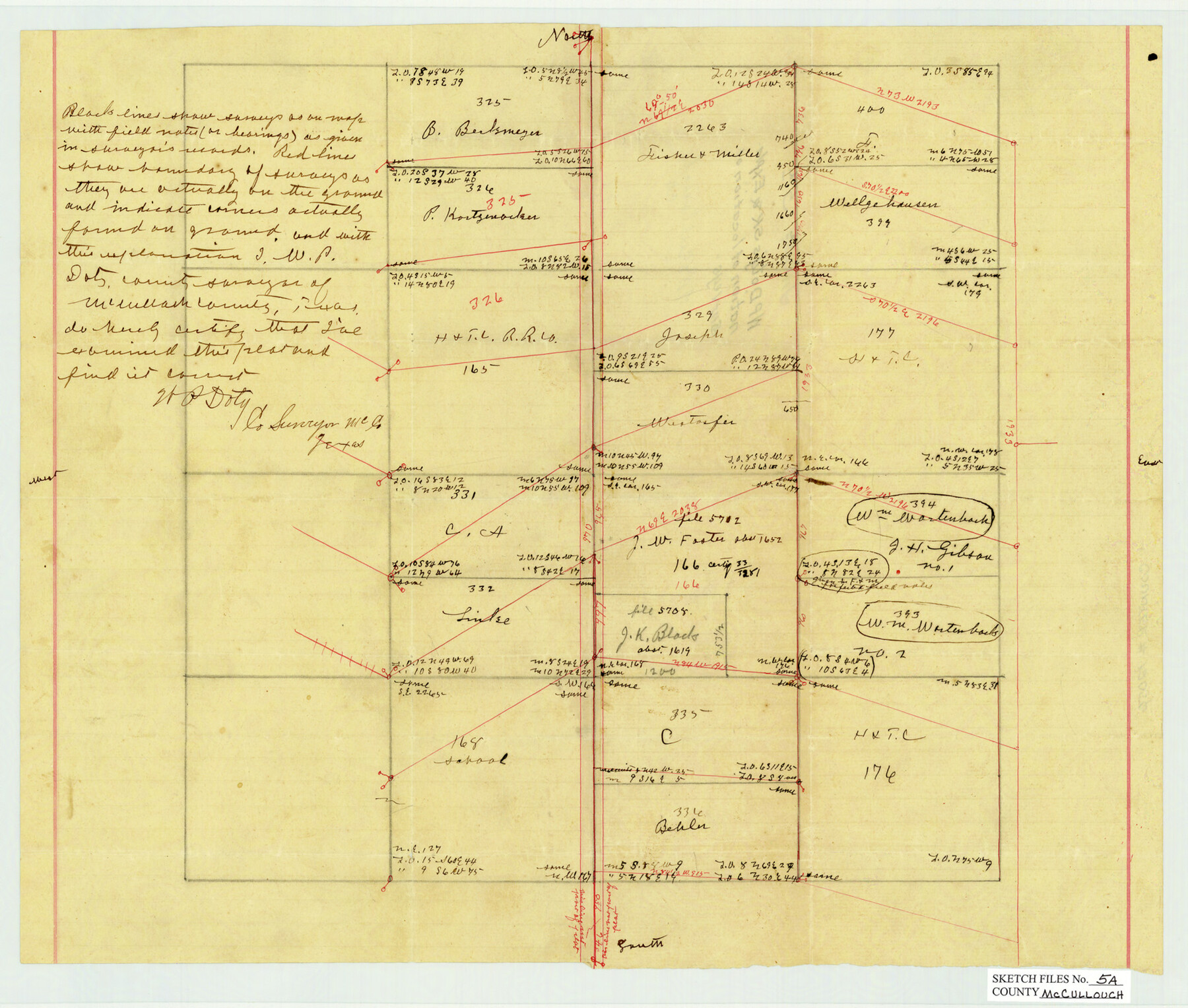
McCulloch County Sketch File 5A
[Sketch of Surveys in McCulloch County, Texas]
-
Map/Doc
12056
-
Collection
General Map Collection
-
People and Organizations
W.P. Doty (Surveyor/Engineer)
-
Counties
McCulloch
-
Subjects
Surveying Sketch File
-
Height x Width
14.8 x 17.4 inches
37.6 x 44.2 cm
-
Medium
paper, manuscript
Part of: General Map Collection
Map of La Salle County

Print $20.00
- Digital $50.00
Map of La Salle County
1878
Size 29.8 x 24.8 inches
Map/Doc 3798
Anderson County Sketch File 27

Print $40.00
- Digital $50.00
Anderson County Sketch File 27
1970
Size 19.5 x 23.7 inches
Map/Doc 10806
Rockwall County Boundary File 3a

Print $6.00
- Digital $50.00
Rockwall County Boundary File 3a
Size 6.2 x 8.7 inches
Map/Doc 58393
Flight Mission No. DQO-3K, Frame 15, Galveston County

Print $20.00
- Digital $50.00
Flight Mission No. DQO-3K, Frame 15, Galveston County
1952
Size 18.7 x 22.4 inches
Map/Doc 85056
Val Verde County Sketch File XX

Print $20.00
- Digital $50.00
Val Verde County Sketch File XX
Size 14.5 x 16.7 inches
Map/Doc 12546
Amistad International Reservoir on Rio Grande 79

Print $20.00
- Digital $50.00
Amistad International Reservoir on Rio Grande 79
1949
Size 28.6 x 40.3 inches
Map/Doc 75508
Fractional Township No. 11 South Range No. 27 East of the Indian Meridian, Indian Territory

Print $20.00
- Digital $50.00
Fractional Township No. 11 South Range No. 27 East of the Indian Meridian, Indian Territory
1897
Size 19.2 x 24.3 inches
Map/Doc 75247
Harris County Working Sketch 77

Print $20.00
- Digital $50.00
Harris County Working Sketch 77
1967
Size 28.6 x 24.0 inches
Map/Doc 65969
Sutton County Rolled Sketch 58

Print $20.00
- Digital $50.00
Sutton County Rolled Sketch 58
Size 31.2 x 15.9 inches
Map/Doc 7896
Little River, Widths of Floodways

Print $6.00
- Digital $50.00
Little River, Widths of Floodways
1921
Size 23.2 x 34.9 inches
Map/Doc 65070
Polk County Rolled Sketch 20

Print $20.00
- Digital $50.00
Polk County Rolled Sketch 20
Size 30.8 x 22.9 inches
Map/Doc 7312
Flight Mission No. DIX-6P, Frame 109, Aransas County

Print $20.00
- Digital $50.00
Flight Mission No. DIX-6P, Frame 109, Aransas County
1956
Size 18.8 x 22.5 inches
Map/Doc 83815
You may also like
Map of DeWitt County

Print $20.00
- Digital $50.00
Map of DeWitt County
1881
Size 22.9 x 26.5 inches
Map/Doc 3477
Fractional Township No. 10 South Range No. 26 East of the Indian Meridian, Indian Territory

Print $20.00
- Digital $50.00
Fractional Township No. 10 South Range No. 26 East of the Indian Meridian, Indian Territory
1897
Size 19.2 x 24.3 inches
Map/Doc 75245
Sketch Showing Division Fence Shelton- Matador, Oldham County, Texas

Print $20.00
- Digital $50.00
Sketch Showing Division Fence Shelton- Matador, Oldham County, Texas
Size 21.7 x 23.7 inches
Map/Doc 91426
Le Nouveau Mexique avec la partie Septentrionale de l'Ancien ou de la Nouvelle Espagne

Print $20.00
- Digital $50.00
Le Nouveau Mexique avec la partie Septentrionale de l'Ancien ou de la Nouvelle Espagne
1780
Size 10.0 x 14.4 inches
Map/Doc 97277
Ellis County Sketch File 19

Print $6.00
- Digital $50.00
Ellis County Sketch File 19
1863
Size 12.4 x 7.8 inches
Map/Doc 21866
Culberson County Rolled Sketch 31

Print $20.00
- Digital $50.00
Culberson County Rolled Sketch 31
Size 44.1 x 34.4 inches
Map/Doc 8747
Maverick County Working Sketch 4

Print $40.00
- Digital $50.00
Maverick County Working Sketch 4
1944
Size 51.3 x 30.7 inches
Map/Doc 70896
Lynn County Sketch File A

Print $2.00
- Digital $50.00
Lynn County Sketch File A
1905
Size 8.6 x 6.3 inches
Map/Doc 30477
Chambers County Sketch File 36

Print $11.00
- Digital $50.00
Chambers County Sketch File 36
1935
Size 15.6 x 9.1 inches
Map/Doc 17647
Flight Mission No. CGI-3N, Frame 143, Cameron County

Print $20.00
- Digital $50.00
Flight Mission No. CGI-3N, Frame 143, Cameron County
1954
Size 18.5 x 22.1 inches
Map/Doc 84616
Victoria County Boundary File 91

Print $12.00
- Digital $50.00
Victoria County Boundary File 91
Size 8.9 x 6.5 inches
Map/Doc 59620
Haskell County

Print $20.00
- Digital $50.00
Haskell County
1873
Size 21.0 x 25.2 inches
Map/Doc 3643