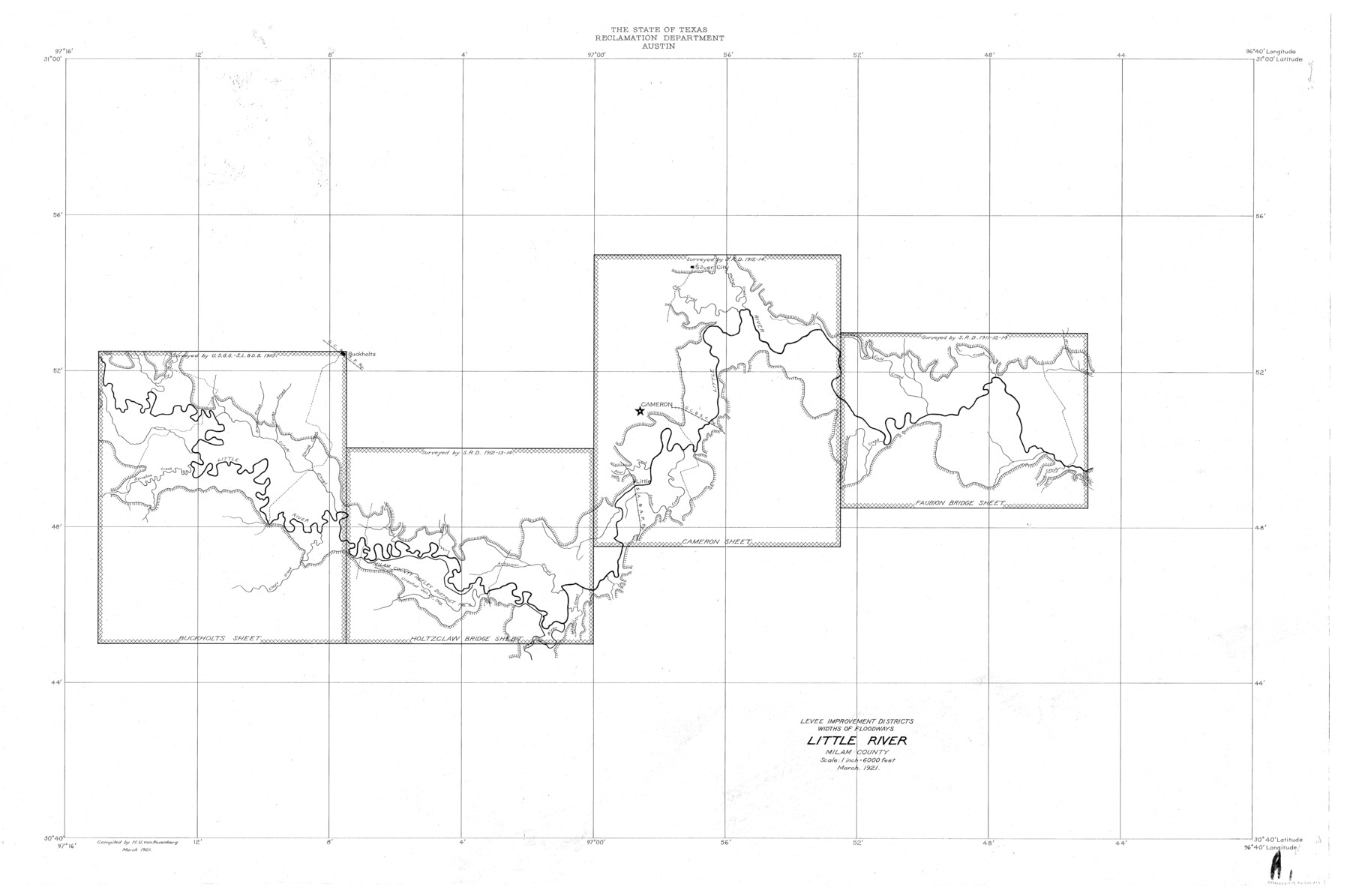
Little River, Widths of Floodways
-
Map/Doc
65070
-
Collection
General Map Collection
-
Object Dates
1921 (Creation Date)
-
People and Organizations
Texas State Reclamation Department (Publisher)
H.U. von Rosenberg (Draftsman)
H.U. von Rosenberg (Compiler)
-
Counties
Milam
-
Subjects
River Surveys Topographic
-
Height x Width
23.2 x 34.9 inches
58.9 x 88.6 cm
-
Comments
Little River is formed by the union of Leon River and Lampasas River. Flows southeasterly into the Brazos River.
Index sheet composed of the Buckholts Sheet, the Holtzclaw Bridge Sheet, the Cameron Sheet and the Faubion Sheet.
Part of: General Map Collection
Map of Hill County

Print $40.00
- Digital $50.00
Map of Hill County
1884
Size 80.0 x 36.8 inches
Map/Doc 93378
Reeves County Sketch File 9

Print $20.00
- Digital $50.00
Reeves County Sketch File 9
Size 46.3 x 38.2 inches
Map/Doc 10587
Flight Mission No. DCL-5C, Frame 2, Kenedy County

Print $20.00
- Digital $50.00
Flight Mission No. DCL-5C, Frame 2, Kenedy County
1943
Size 18.5 x 22.5 inches
Map/Doc 85827
Duval County Sketch File 84

Print $6.00
- Digital $50.00
Duval County Sketch File 84
1945
Size 14.4 x 8.9 inches
Map/Doc 21531
Andrews County Working Sketch 15

Print $40.00
- Digital $50.00
Andrews County Working Sketch 15
1957
Size 50.5 x 36.1 inches
Map/Doc 67061
Map of Live Oak County

Print $20.00
- Digital $50.00
Map of Live Oak County
1878
Size 27.4 x 20.8 inches
Map/Doc 3823
Duval County Working Sketch 12

Print $20.00
- Digital $50.00
Duval County Working Sketch 12
1937
Size 22.1 x 27.8 inches
Map/Doc 68725
Terrell County Working Sketch 15

Print $20.00
- Digital $50.00
Terrell County Working Sketch 15
1927
Size 18.7 x 19.8 inches
Map/Doc 62164
Nueces County Rolled Sketch 125

Print $34.00
Nueces County Rolled Sketch 125
1998
Size 18.1 x 25.0 inches
Map/Doc 7160
Tom Green County Sketch File 75

Print $20.00
- Digital $50.00
Tom Green County Sketch File 75
1950
Size 18.1 x 22.5 inches
Map/Doc 12449

North end of Brazos Island

Print $20.00
- Digital $50.00
North end of Brazos Island
Size 26.0 x 18.2 inches
Map/Doc 72916
You may also like
Harris County Rolled Sketch 60

Print $20.00
- Digital $50.00
Harris County Rolled Sketch 60
1927
Size 27.4 x 21.3 inches
Map/Doc 6106
Tyler County Working Sketch 1

Print $20.00
- Digital $50.00
Tyler County Working Sketch 1
1911
Size 19.0 x 15.0 inches
Map/Doc 69471
Map of the Western States designed to accompany Smith's Geography for Schools

Print $20.00
- Digital $50.00
Map of the Western States designed to accompany Smith's Geography for Schools
1850
Size 12.2 x 19.1 inches
Map/Doc 93889
[Leagues 258, 259, 278, 287, 288, and Vicinity]
![91459, [Leagues 258, 259, 278, 287, 288, and Vicinity], Twichell Survey Records](https://historictexasmaps.com/wmedia_w700/maps/91459-1.tif.jpg)
Print $20.00
- Digital $50.00
[Leagues 258, 259, 278, 287, 288, and Vicinity]
Size 20.0 x 34.9 inches
Map/Doc 91459
United States - Gulf Coast - Galveston to Rio Grande

Print $20.00
- Digital $50.00
United States - Gulf Coast - Galveston to Rio Grande
1919
Size 26.5 x 18.2 inches
Map/Doc 72747
La Salle County Working Sketch 23

Print $20.00
- Digital $50.00
La Salle County Working Sketch 23
1947
Size 30.5 x 31.6 inches
Map/Doc 70324
Map of Nolan County

Print $20.00
- Digital $50.00
Map of Nolan County
1896
Size 28.8 x 23.5 inches
Map/Doc 3915
Anderson County Working Sketch 40

Print $20.00
- Digital $50.00
Anderson County Working Sketch 40
1986
Size 17.0 x 20.3 inches
Map/Doc 67040
San Jacinto County Rolled Sketch 8

Print $20.00
- Digital $50.00
San Jacinto County Rolled Sketch 8
1940
Size 33.6 x 35.1 inches
Map/Doc 7559
Pecos County Sketch File 70

Print $20.00
- Digital $50.00
Pecos County Sketch File 70
1939
Size 21.3 x 20.7 inches
Map/Doc 12181
Intracoastal Waterway - Galveston Bay to West Bay including Galveston Bay Entrance

Print $20.00
- Digital $50.00
Intracoastal Waterway - Galveston Bay to West Bay including Galveston Bay Entrance
1957
Size 27.2 x 38.6 inches
Map/Doc 69932
Flight Mission No. DIX-5P, Frame 110, Aransas County

Print $20.00
- Digital $50.00
Flight Mission No. DIX-5P, Frame 110, Aransas County
1956
Size 17.7 x 18.3 inches
Map/Doc 83789