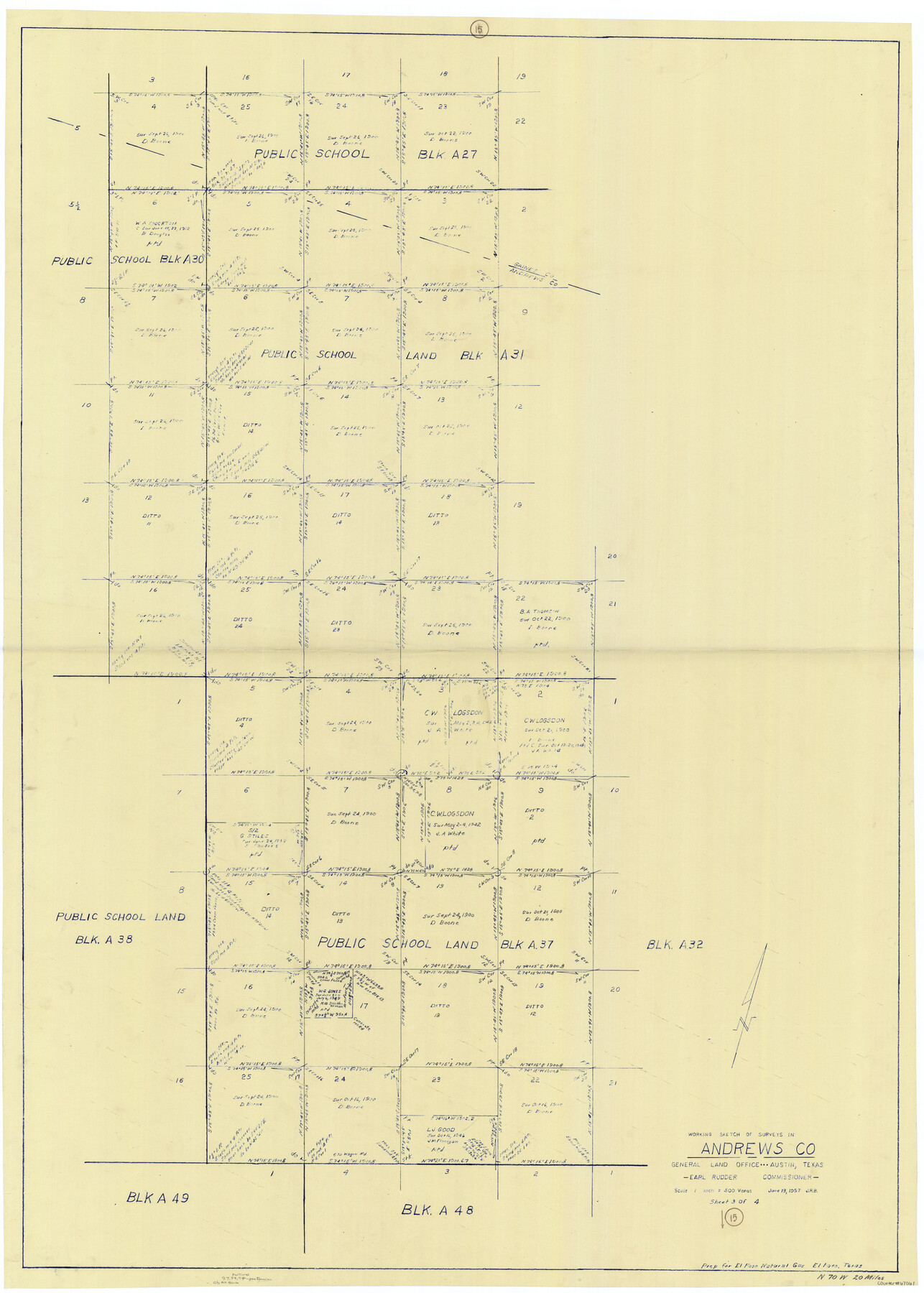
Andrews County Working Sketch 15
-
Map/Doc
67061
-
Collection
General Map Collection
-
Object Dates
6/13/1957 (Creation Date)
-
People and Organizations
J. Earl Rudder (GLO Commissioner)
-
Counties
Andrews
-
Subjects
Surveying Working Sketch
-
Height x Width
50.5 x 36.1 inches
128.3 x 91.7 cm
-
Scale
1" = 500 varas
-
Comments
Surveys located about 20 miles North 70 degrees West of Andrews, Texas.
Part of: General Map Collection
Hockley County Sketch File 11

Print $8.00
- Digital $50.00
Hockley County Sketch File 11
Size 14.3 x 9.0 inches
Map/Doc 26544
Edwards County Working Sketch 95

Print $20.00
- Digital $50.00
Edwards County Working Sketch 95
1968
Size 26.0 x 24.9 inches
Map/Doc 68971
Uvalde County Boundary File 2

Print $5.00
- Digital $50.00
Uvalde County Boundary File 2
Size 13.1 x 9.5 inches
Map/Doc 59556
Reeves County Rolled Sketch 30

Print $20.00
- Digital $50.00
Reeves County Rolled Sketch 30
1988
Size 18.4 x 24.4 inches
Map/Doc 7499
[Atchison, Topeka & Santa Fe from Paisano to south of Plata]
![64709, [Atchison, Topeka & Santa Fe from Paisano to south of Plata], General Map Collection](https://historictexasmaps.com/wmedia_w700/maps/64709.tif.jpg)
Print $40.00
- Digital $50.00
[Atchison, Topeka & Santa Fe from Paisano to south of Plata]
Size 32.3 x 120.8 inches
Map/Doc 64709
Marion County Rolled Sketch 1A

Print $15.00
- Digital $50.00
Marion County Rolled Sketch 1A
1954
Size 9.9 x 15.2 inches
Map/Doc 46610
Right of Way & Track Map, St. Louis, Brownsville & Mexico Ry. operated by St. Louis, Brownsville & Mexico Ry. Co.

Print $40.00
- Digital $50.00
Right of Way & Track Map, St. Louis, Brownsville & Mexico Ry. operated by St. Louis, Brownsville & Mexico Ry. Co.
1919
Size 25.2 x 57.1 inches
Map/Doc 64613
Hardeman County Aerial Photograph Index Sheet 1

Print $20.00
- Digital $50.00
Hardeman County Aerial Photograph Index Sheet 1
1950
Size 19.8 x 17.0 inches
Map/Doc 83697
Comal County Working Sketch 19

Print $20.00
- Digital $50.00
Comal County Working Sketch 19
2006
Size 18.8 x 29.0 inches
Map/Doc 83094
Rusk County Sketch File 26

Print $20.00
Rusk County Sketch File 26
1932
Size 38.1 x 22.6 inches
Map/Doc 10595
Real County Working Sketch 39

Print $20.00
- Digital $50.00
Real County Working Sketch 39
1951
Size 33.5 x 36.6 inches
Map/Doc 71931
Map of the country in the vicinity of San Antonio de Bexar reduced in part from the county map of Bexar with additions by J. Edmd. Blake, 1st Lieut Topl. Engs.

Print $20.00
- Digital $50.00
Map of the country in the vicinity of San Antonio de Bexar reduced in part from the county map of Bexar with additions by J. Edmd. Blake, 1st Lieut Topl. Engs.
1845
Size 18.3 x 26.1 inches
Map/Doc 72720
You may also like
Sutton County Rolled Sketch 66

Print $20.00
- Digital $50.00
Sutton County Rolled Sketch 66
Size 25.3 x 25.1 inches
Map/Doc 7901
Haskell County Rolled Sketch 15

Print $20.00
- Digital $50.00
Haskell County Rolled Sketch 15
1991
Size 12.7 x 18.4 inches
Map/Doc 6173
Hardeman County Sketch File 12

Print $4.00
- Digital $50.00
Hardeman County Sketch File 12
Size 12.8 x 8.3 inches
Map/Doc 25020
Sutton County Rolled Sketch 57

Print $40.00
- Digital $50.00
Sutton County Rolled Sketch 57
1958
Size 40.1 x 51.1 inches
Map/Doc 10662
Dickens County Working Sketch 9

Print $20.00
- Digital $50.00
Dickens County Working Sketch 9
1947
Size 18.5 x 29.6 inches
Map/Doc 68657
Rio Grande Rectification Project, El Paso and Juarez Valley

Print $20.00
- Digital $50.00
Rio Grande Rectification Project, El Paso and Juarez Valley
1935
Size 10.7 x 29.6 inches
Map/Doc 60862
Coleman County Sketch File 2

Print $2.00
- Digital $50.00
Coleman County Sketch File 2
Size 8.4 x 3.3 inches
Map/Doc 18669
Erath County Working Sketch 3

Print $20.00
- Digital $50.00
Erath County Working Sketch 3
1919
Size 17.6 x 17.6 inches
Map/Doc 69084
Lynn County Rolled Sketch H

Print $20.00
- Digital $50.00
Lynn County Rolled Sketch H
1902
Size 43.6 x 38.4 inches
Map/Doc 9472
Lee County Working Sketch 20

Print $20.00
- Digital $50.00
Lee County Working Sketch 20
1992
Size 25.3 x 35.4 inches
Map/Doc 70399
Colton's New Map of the State of Texas Compiled from J. DeCordova's large Map

Print $20.00
Colton's New Map of the State of Texas Compiled from J. DeCordova's large Map
1858
Size 17.0 x 26.2 inches
Map/Doc 79736
Flight Mission No. DQN-4K, Frame 4, Calhoun County

Print $20.00
- Digital $50.00
Flight Mission No. DQN-4K, Frame 4, Calhoun County
1953
Size 18.8 x 22.3 inches
Map/Doc 84369